James Spann: Cloudy, wet day for Alabama
James Spann has the midweek forecast for Alabama from Alabama NewsCenter on Vimeo.
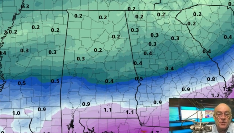
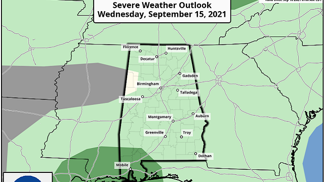
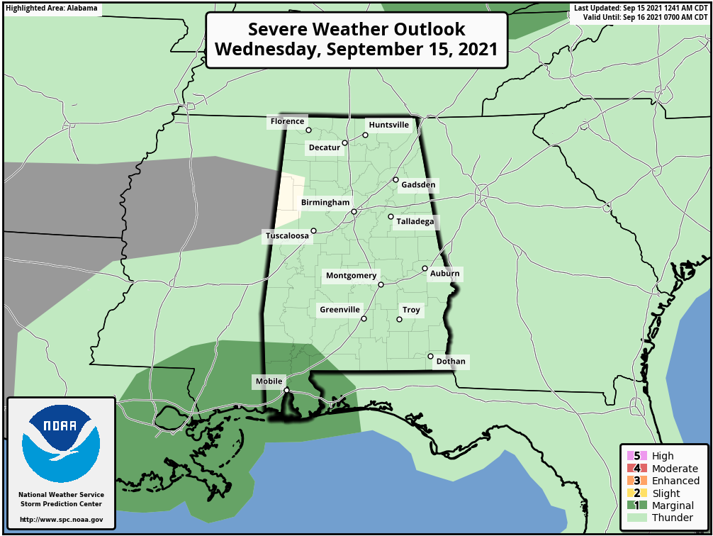
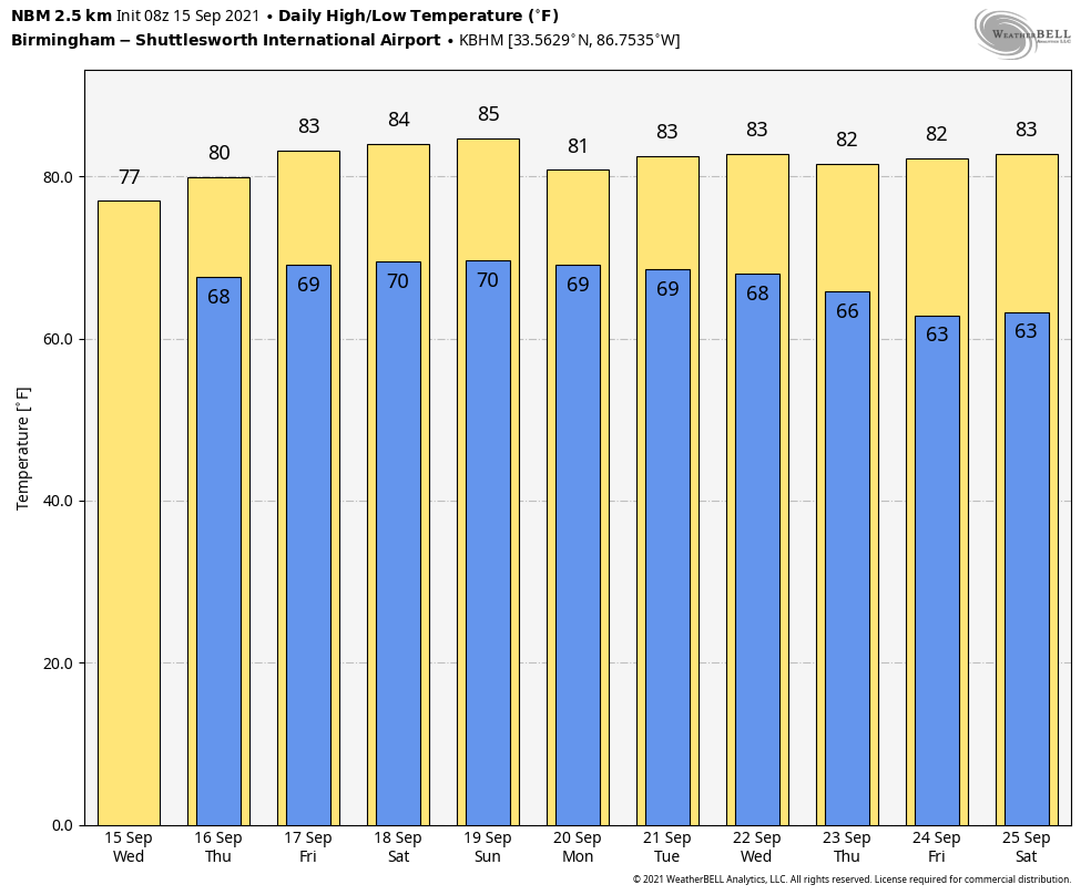
RADAR CHECK: Rain is fairly widespread across Alabama early this morning, thanks to the remnant circulation of Nicholas that is over Louisiana. Today will be cloudy with periods of rain and maybe a rumble of thunder; temperatures will hold in the 70s all day. The Storm Prediction Center maintains a marginal risk (level 1 out of 5) today for the southwest corner of Alabama, where a brief, isolated tornado can’t be ruled out.
THURSDAY/FRIDAY: Showers will become more scattered Thursday and Friday as Nicholas dissipates. The sky will be generally cloudy, although the sun could pop out at times; odds of any one spot getting wet both days are 30-40%. The high will be in the 77- to 80-degree range Thursday, followed by low 80s Friday.
THE ALABAMA WEEKEND: Global models have trended a bit drier for the northern and eastern counties of the state, with the deeper moisture over west and south Alabama. We will adjust our forecast a bit to reflect this; the best chance of showers and thunderstorms over the weekend will be in areas west and south of Birmingham. North and east Alabama will see only widely scattered showers with a partly sunny sky both days. Highs over the weekend will be in the mid 80s, right at seasonal averages.
NEXT WEEK: We will roll with a persistence forecast for now — partly sunny days with scattered showers and thunderstorms possible mostly from noon to midnight. Highs will be in the 80s.
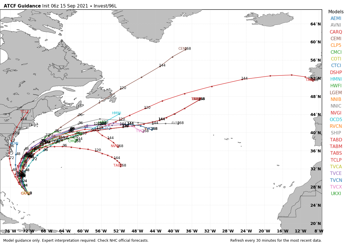
TROPICS: Nicholas will dissipate over Louisiana over the next 36 hours. Otherwise, there are two waves to watch in the Atlantic. One is east of the Bahamas (Invest 96L), and the National Hurricane Center gives it a high chance of becoming a tropical depression or storm over the next two days. This feature will move parallel to the East Coast of the U.S. but should remain offshore by several hundred miles. It will ultimately move into the North Atlantic, where it becomes post-tropical.
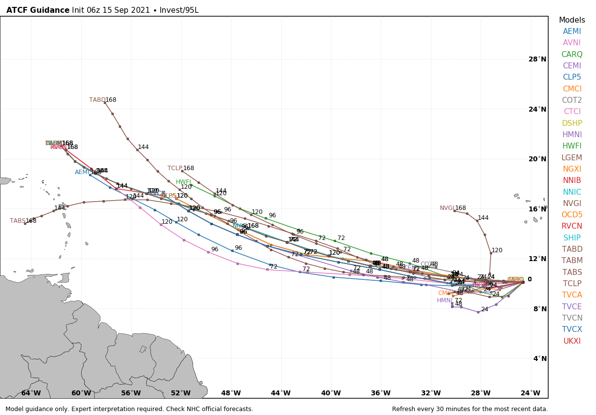
Out in the eastern Atlantic, Invest 95L also has a high chance of becoming a depression or storm by Friday. It is expected to be just north of the Leeward Islands in four to five days; it’s too early to know whether this system will affect the U.S.
There are no systems threatening the central Gulf Coast (Gulf Shores to Panama City Beach) through the weekend.
FOOTBALL WEATHER: For the high school games Friday night, the sky will be mostly cloudy, and a shower is possible for a few stadiums, but for now the rain doesn’t look to be especially widespread. Temperatures will fall slowly through the mid to upper 70s during the games.
ALABAMA AT FLORIDA (2:30 p.m. CT kickoff): It will be a warm, humid day in Gainesville. The sun will be out at times, but there is a pretty good chance of a few passing showers or thunderstorms during the game (take the rain gear). Temperatures will fall from near 84 at kickoff into the low 80s by the fourth quarter.
AUBURN AT PENN STATE (6:30 p.m. CT kickoff): A passing shower can’t be ruled out during the game in State College (especially the first half); otherwise it will be mostly fair with temperatures falling from around 80 at kickoff into the low 70s by the final whistle.
UAB AT NORTH TEXAS (6:30 p.m. CT kickoff): The sky will be clear in Denton, Texas, Saturday evening. Temperatures will fall from around 90 degrees at kickoff to near 80 by the fourth quarter.
NORTH ALABAMA AT JACKSONVILLE STATE (6 p.m. kickoff): It will be a warm, humid Saturday night; a shower or storm can’t be ruled out, mainly during the first half. Temperatures will fall from near 80 at kickoff into the mid 70s by the final whistle.
TROY AT SOUTHERN MISS (6 p.m. kickoff): A few showers are likely during the first half of the game; otherwise it will be a warm, humid night in Hattiesburg, with temperatures falling from the low 80s into the upper 70s.
ON THIS DATE IN 1945: A hurricane entered the south Florida coast at Homestead, curving northward right up through the center of Florida, remaining over land, and exited near Jacksonville Beach with winds gusting to 170 mph. The following is from the Homestead Air Reserve Base. “On Sept. 15, 1945, three years to the day after the founding of the Homestead Army Air Field, a massive hurricane roared ashore, sending winds of up to 145 miles per hour tearing through the Air Field’s buildings. Enlisted housing facilities, the nurses’ dormitory and the Base Exchange were all destroyed. The roof was ripped from what would later become building 741, the Big Hangar. The base laundry and fire station were both declared total losses. The few remaining aircraft were tossed about like leaves.”
BEACH FORECAST: Click here to see the AlabamaWx Beach Forecast Center page.
WEATHER BRAINS: You can listen to our weekly 90-minute show any time on your favorite podcast app. This is the show all about weather featuring many familiar voices, including the meteorologists at ABC 33/40.
CONNECT: You can find me on the major social networks:
For more weather news and information from James Spann and his team, visit AlabamaWx.