James Spann: Wet weather for Alabama through Wednesday; Flash Flood Watch in effect
James Spann forecasts rain for Alabama through midweek from Alabama NewsCenter on Vimeo.
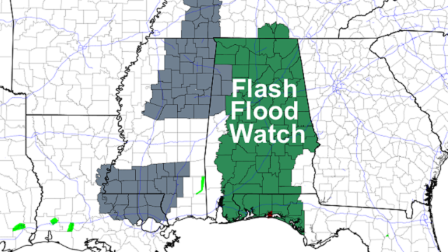
WET PATTERN: An upper low will develop west of the state today and will bring wet, unsettled conditions through midweek. A Flash Flood Watch is in effect for most of Alabama; rain amounts between 1 and 3 inches are likely over the next 72 hours, with isolated heavier amounts.
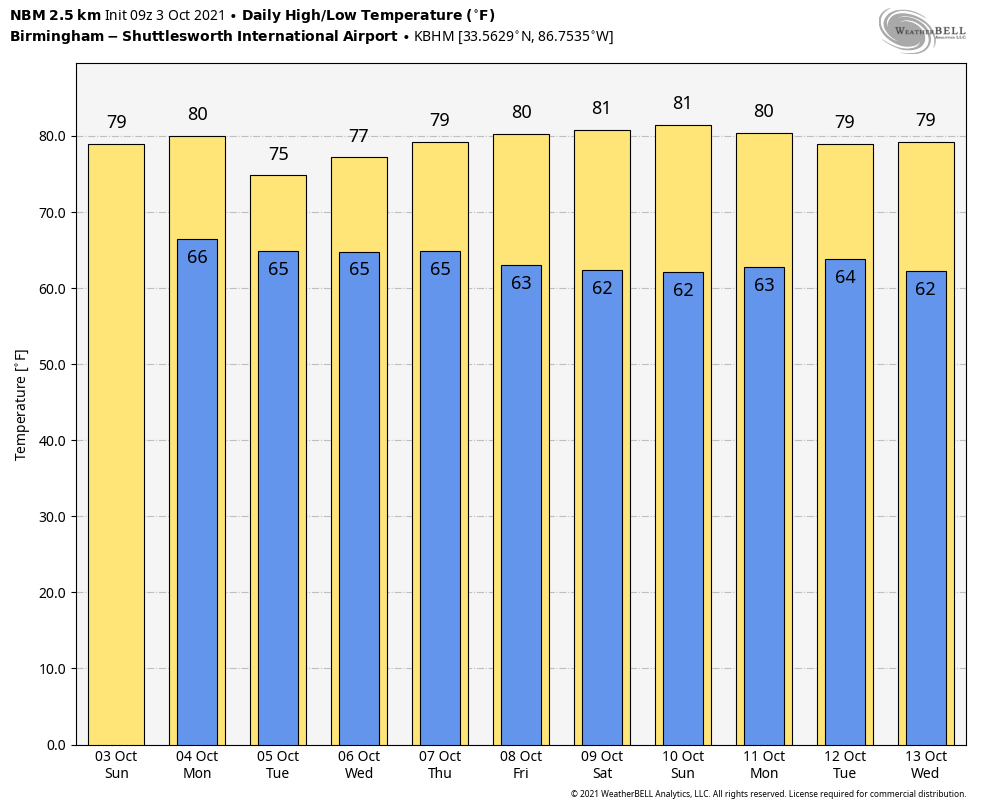
Look for occasional showers today and a rumble of thunder in spots. It won’t rain all day, and you might even see a peek of the sun at times. We project a high in the upper 70s; the average high for Birmingham on Oct. 4 is 81.
REST OF THE WEEK: Periods of rain and a few thunderstorms are likely Tuesday and Wednesday as the upper low hangs around to the west. Rain could be heavy at times, and temperatures won’t get past the mid 70s because of clouds and rain.
Showers thin out on Thursday as the upper low opens up into a trough and begins to lift out, and Friday will be dry with a partly to mostly sunny sky. The high will be in the upper 70s Thursday, followed by low 80s Friday.
THE ALABAMA WEEKEND: Dry weather will continue; look for sunny days and fair nights. Highs will be in the low 80s, with lows between 58 and 63 degrees. These values are very close to seasonal averages for early October in Alabama.
NEXT WEEK: For now it looks like most of next week will be dry; highs will be in the 78- to 82-degree range, with lows not too far from 60 degrees.
 TALLADEGA TODAY: For today’s scheduled running of the YellaWood 500, the weather won’t be much different from Sunday. Occasional showers are likely, but it won’t rain all day, and there is a chance they get the race in. But dodging showers for a NASCAR event is much different than a football game due to the time it takes to dry the track. Temperatures will hold in the 70s all day at Talladega.
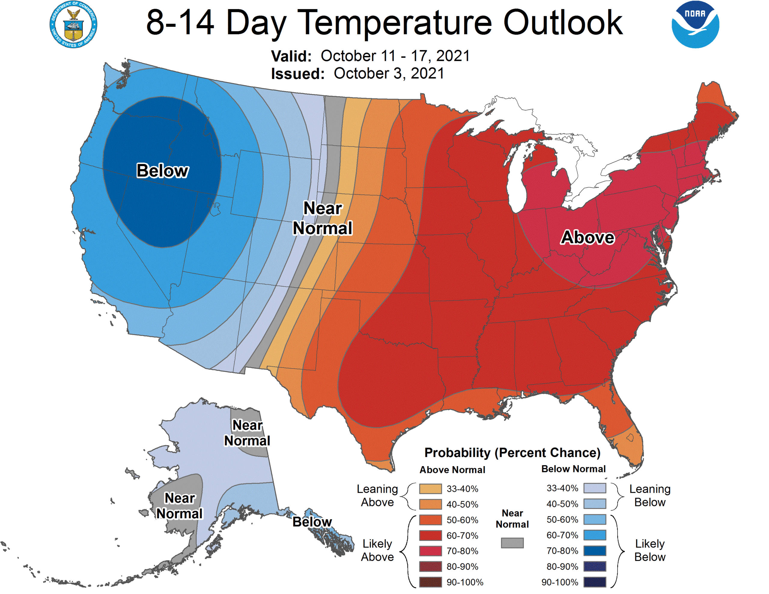
LONG RANGE: The latest Climate Prediction Center outlook for Oct. 11-17 suggests temperatures will be above average across the Deep South and the eastern half of the nation. There’s no sign of a major chance for colder temperatures here through midmonth. The average low does not drop below 50 degrees at Birmingham until Oct. 27.
TROPICS: Victor, in the Central Atlantic, is dissipating. Hurricane Sam, in the North Atlantic, becomes post-tropical in the colder water Tuesday. The National Hurricane Center is monitoring a tropical wave north of Hispaniola; it is moving to the northwest but has only a low chance (20%) of developing due to harsh upper-air winds. The rest of the Atlantic basin, including the Gulf of Mexico, is quiet.
ON THIS DATE IN 2005: Hurricane Stan, a minimal Category 1 hurricane with 75 mph maximum sustained surface winds, made landfall near Punta Roca Partida, Mexico. While not a particularly strong hurricane, the torrential rains caused flooding and landslides, which resulted in 1,513 deaths in Guatemala.
BEACH FORECAST: Click here to see the AlabamaWx Beach Forecast Center page.
WEATHER BRAINS: You can listen to our weekly 90-minute show any time on your favorite podcast app. This is the show all about weather featuring many familiar voices, including the meteorologists at ABC 33/40.
CONNECT: You can find me on the major social networks:
For more weather news and information from James Spann and his team, visit AlabamaWx.


