James Spann: Flash Flood Watch for much of Alabama; wet through Thursday
James Spann forecasts more rain for Alabama from Alabama NewsCenter on Vimeo.
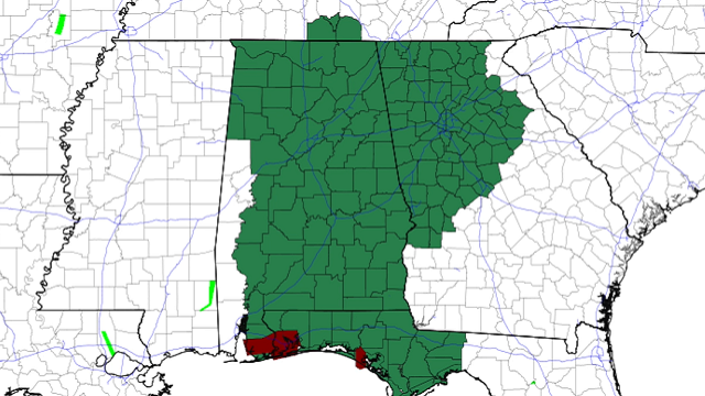
RADAR CHECK: Rain is widespread early this morning in areas east and south of Montgomery; a Flash Flood Warning is in effect for parts of Lee and Chambers counties until 11:15 a.m. A band of moderate to heavy rain is also moving into the Birmingham metro from the south; a Flood Advisory is in effect for parts of Jefferson and Shelby counties.
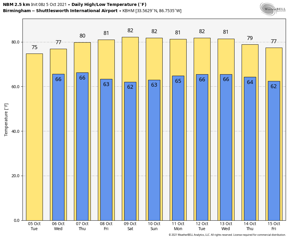
An upper low to the west will keep the weather wet at times across Alabama through tonight; the rain could be heavy at times. A Flash Flood Watch is in effect for most of the state. And the Storm Prediction Center has a marginal risk of severe thunderstorms defined for far west Alabama; some hail is possible there due to the cold air aloft associated with the upper low over the Mississippi Delta.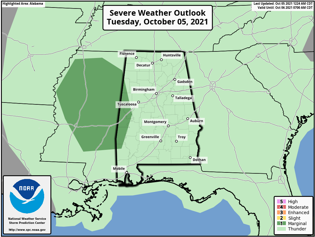 The weather won’t change much Wednesday; periods of rain and a few thunderstorms are likely as the upper low to the west drifts slowly northward. Temperatures won’t get past the mid 70s because of clouds and rain. Showers are also likely Thursday, but rain amounts should be lighter as the upper low opens up and begins to move away.
FRIDAY AND THE WEEKEND: Dry air returns to the state; the sky will be partly to mostly sunny Friday, and we expect a mostly sunny sky over the weekend. The highs will be in the low 80s Friday and Saturday, followed by mid 80s Sunday. Lows will be in the 60s.
NEXT WEEK: New model data suggests enough moisture could return for a few isolated showers during the first half of the week, but an upper ridge will be in place and any rain should be light and very spotty. Temperatures will be above average next week with highs between 80 and 85 degrees.
YESTERDAY’S RAIN: Here are some of the heavier rain totals across Alabama yesterday:
- Clanton — 3.96 inches
- Montgomery — 2.69
- Birmingham Airport — 2.57
- Crestwood — 2.31
- Bluff Park — 2.03
- Jemison — 1.82
- Gulf Shores — 1.77
- Mountain Brook — 1.39
- Alabaster — 1.19
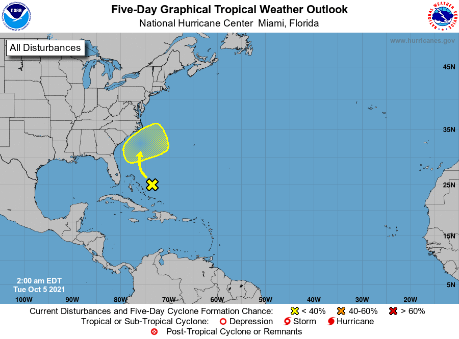
TROPICS: The Atlantic basin has become very quiet. A disturbance east of the Bahamas is not expected to develop (only a 10% chance), and tropical storm formation is not expected over the next five days.
ON THIS DATE IN 1864: A tropical cyclone hit India near Calcutta, devastating the city and killing about 60,000 people.
ON THIS DATE IN 1972: Tropical Storm Joanne, earlier a hurricane, moved across the Baja California peninsula and came ashore in western Mexico south of Ajo. The storm brought heavy rain and flooding to much of Arizona. This storm is the first documented tropical storm to reach Arizona with its cyclonic circulation intact. More than 5 inches of rain was reported on the Mogollon rim southeast of Flagstaff.
BEACH FORECAST: Click here to see the AlabamaWx Beach Forecast Center page.
WEATHER BRAINS: You can listen to our weekly 90-minute show any time on your favorite podcast app. This is the show all about weather featuring many familiar voices, including the meteorologists at ABC 33/40.
CONNECT: You can find me on the major social networks:
For more weather news and information from James Spann and his team, visit AlabamaWx.


