James Spann: Nice warm-up for Alabama Monday; rain returns Thursday
James Spann forecasts warmer weather for Alabama, temporarily from Alabama NewsCenter on Vimeo.
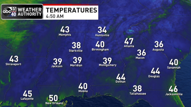
ANOTHER COLD START: Here are some temperatures just before sunrise across Alabama this morning:
- Gadsden — 33
- Decatur — 33
- Hueytown — 34
- Huntsville — 34
- Trussville — 34
- Talladega — 34
- Lay Lake — 34
- Fort Payne — 34
- Anniston — 35
- Cullman — 36
- Sylacauga — 37
- Tuscaloosa — 39
- Birmingham — 40
- Mobile — 41
- Dothan — 43
We expect a nice warm-up today; most places reach the low 70s this afternoon with a sunny sky. Dry, pleasant weather continues Tuesday and Wednesday, with highs between 71 and 75 degrees and a good supply of sunshine both days.
RAIN RETURNS THURSDAY: A cold front will bring clouds into Alabama Thursday. Periods of rain are likely Thursday afternoon and Thursday night; a few thunderstorms are possible as well, but severe storms are not expected with the main dynamic support passing well to the north. The main window for rain will come from noon to midnight, and amounts of around one-half inch are expected. The high will be in the low 70s for most places.
FRIDAY AND THE WEEKEND: The sky becomes partly to mostly sunny Friday with a brisk north wind; the high will drop into the 60- to 65-degree range. The weekend will be dry and colder; we expect a sunny sky Saturday and Sunday with highs in the 50s. Temperatures will be close to freezing by early Sunday morning.
NEXT WEEK: For now the week looks dry with highs between 56 and 63 degrees, and lows in the 30s and 40s. There’s still no sign of any severe thunderstorm threat for the next 10 days.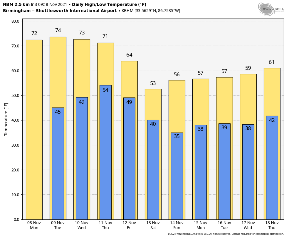
TROPICS: A non-tropical low-pressure system with storm-force winds is a couple of hundred miles southeast of Cape Hatteras, North Carolina. This system is forecast to move east-northeastward during the next several days, and it could gradually lose its frontal characteristics by the middle of this week over the subtropical Atlantic Ocean. Thereafter, the low could acquire some subtropical characteristics while it moves eastward or east-northeastward over the open waters of the central Atlantic Ocean.
The rest of the Atlantic basin is quiet.
ON THIS DATE IN 1913: The Great Lakes Storm of Nov. 7-13 was a blizzard with hurricane-force winds that devastated the Great Lakes Region, sinking as many as 19 ships and stranding 19 others. This storm would be the deadliest and most destructive natural disaster ever to hit the Great Lakes.
ON THIS DATE IN 1994: The 12th and final tropical cyclone of the Atlantic hurricane season formed in the southwestern Caribbean. While Hurricane Gordon was only a Category 1, it killed 1,149 people, including 1,122 in Haiti.
BEACH FORECAST: Click here to see the AlabamaWx Beach Forecast Center page
WEATHER BRAINS: You can listen to our weekly 90-minute show any time on your favorite podcast app. This is the show all about weather featuring many familiar voices, including the meteorologists at ABC 33/40.
CONNECT: You can find me on the major social networks:
For more weather news and information from James Spann and his team, visit AlabamaWx.


