James Spann: Warming trend begins in Alabama this afternoon
James Spann forecasts a warm-up for Alabama from Alabama NewsCenter on Vimeo.
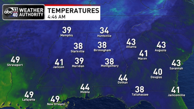
ANOTHER COLD START: A peek at some of the temperatures across Alabama just before sunrise today:
- Black Creek — 28
- Haleyville — 30
- Fort Payne — 30
- Huntsville — 31
- Talladega — 32
- Pell City — 32
- Anniston — 33
- Gadsden — 33
- Sylacauga — 33
- Alexander City — 33
- Decatur — 33
- Cullman — 34
- Trussville — 34
- Tuscaloosa — 37
- Birmingham — 38
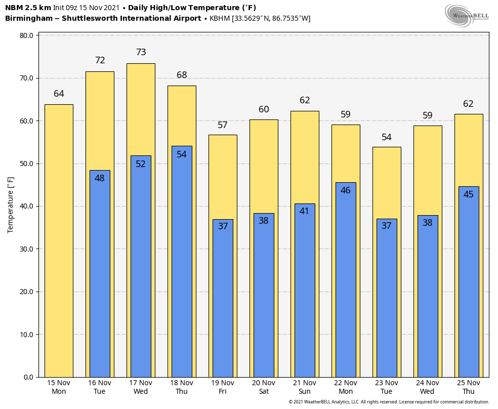
Look for a nice warm-up across the state today; temperatures reach the mid 60s this afternoon with a good supply of sunshine. Dry weather continues through Wednesday with a warming trend; with a sunny sky look for low 70s Tuesday and mid 70s Wednesday.
Clouds return to Alabama Thursday, and a cold front will bring a chance of showers to the northern half of the state by afternoon. Moisture will be limited, and rain amounts should be less than one-quarter inch for most places. The high Thursday will be in the upper 60s.
FRIDAY AND THE WEEKEND: Friday will be sunny and cooler, with a high in the 50s. Sunny weather continues Saturday; after a morning low in the 30s we expect a high in the 60s. The day Sunday will be dry, but clouds will increase by afternoon, and some rain is possible late in the day and Sunday night as an upper trough passes through the region. Again, moisture will be limited and rain amounts should be fairly light. Sunday’s high will be between 62 and 66 degrees.
THANKSGIVING WEEK: For now the week looks quiet across Alabama, the Deep South and much of the U.S. as dry air will prevail. The latest Climate Prediction Center outlook for Nov. 22-28 suggests temperatures will be below average over the eastern half of the nation.
 There’s still no sign of any severe weather threat for Alabama for the next seven to 10 days.
ON THIS DATE IN 1989: A squall line entered northwest Alabama around 3, and at that point it looked like the primary issue during the afternoon and evening was going to be straight-line winds along the line. Around 4:20, an isolated cell merged with the squall line over the southwest part of Huntsville, near Redstone Arsenal, and within minutes an F4 tornado dropped from the sky, moving through the southern part of Huntsville.
It would destroy or damage 80 businesses, three churches, a dozen apartment buildings and more than 1,000 cars. It moved on, climbing over Garth Mountain, demolishing Jones Valley Elementary School and destroying 259 homes in the Jones Valley area. All told, the tornado killed 21 people and injured 463. And, unfortunately, there was no tornado warning until several minutes after the twister touched down; this was before Doppler Radar was in operational use in Alabama.
The day after the tornado, icy cold air and snow squalls moved into north Alabama as search and rescue operations continued. Visibility at times dropped to a fraction of a mile in heavy snow in Huntsville Nov. 16, 1989.
BEACH FORECAST: Click here to see the AlabamaWx Beach Forecast Center page.
WEATHER BRAINS: You can listen to our weekly 90-minute show any time on your favorite podcast app. This is the show all about weather featuring many familiar voices, including the meteorologists at ABC 33/40.
CONNECT: You can find me on the major social networks:
For more weather news and information from James Spann and his team, visit AlabamaWx.


