James Spann: Colder air rolls into Alabama; occasional showers stay in the forecast
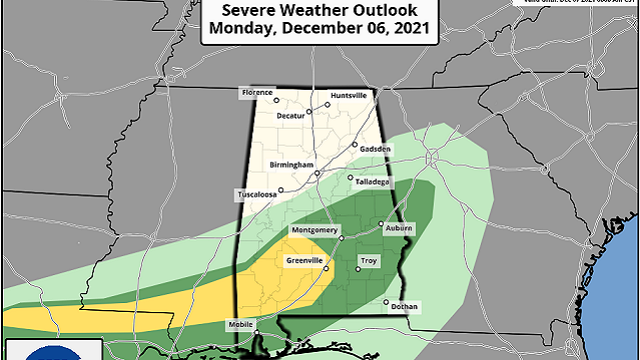
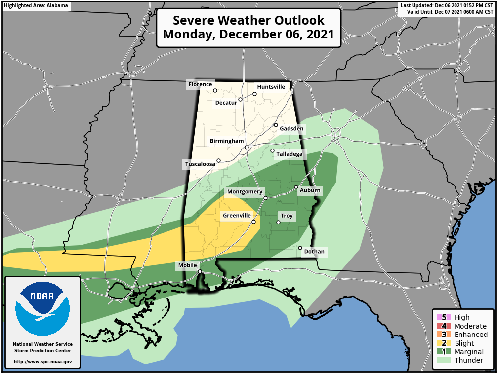
RADAR CHECK: Rain continues this afternoon generally south of a line from Wedowee to Marion to Butler; a few strong storms are in progress, but there are no warnings in effect at mid-afternoon. The Storm Prediction Center maintains a slight risk (level 2 of 5) for parts of southwest Alabama and a marginal risk (level 1 of 5) for the rest of south Alabama through the evening.
Temperatures continue to fall across north Alabama behind the cold front; some communities are now in the upper 40s. The sky will slowly clear over the northern half of the state tonight, with temperatures between 30 and 35 degrees by daybreak. Clouds and showers will linger over south Alabama tonight as the front becomes nearly stationary.
REST OF THE WEEK: With the front hanging around, there will be some chance of showers pretty much daily through Friday. During the day Tuesday, most of the showers will be found over south Alabama, but showers are likely statewide late Tuesday night into Wednesday morning as a wave of low pressure moves along the front. There will be a wide temperature spread across the state Tuesday; some communities over the Tennessee Valley won’t get out of the 40s, but near the Gulf Coast the high will be between 65 and 70 degrees.
The front moves northward as a warm front Thursday. A few scattered showers are possible, and the high will be in the upper 60s over north and central Alabama. Highs in the mid 70s are likely Friday, not far from record levels for early December in Alabama. Scattered showers and storms are possible Friday and Friday night, but it won’t be a washout.
THE ALABAMA WEEKEND: Saturday and Saturday night continue to look wet and stormy as another cold front approaches. Rain amounts of 1-2 inches are likely, and strong storms are a distinct possibility as the air will be unstable. For now, we aren’t seeing signals of a major severe weather threat, but this event is still five days away, so we will watch model trends closely. Saturday’s high will be between 65 and 70 degrees.
Cooler, drier air arrives Sunday. The day will be mostly sunny with a high in the low 50s.
NEXT WEEK: An upper ridge will build over much of the contiguous U.S., meaning mostly rain-free conditions. The high will be in the upper 50s Monday, then mostly in the 60s for the rest of the week. We are still seeing trends in global models that the ridge will hold through mid-December, with temperatures above average in the Dec. 14-20 time frame.
ON THIS DATE IN 1983: A pre-dawn tornado tore through Selma, killing an elderly man and injuring 18 people. This happened just three days after the Oxford tornado on Dec. 3, which also brought loss of life. Some of the heaviest damage in Selma that morning was in the Rangedale Housing Project, Selma University and a Broad Street business district.
BEACH FORECAST: Click here to see the AlabamaWx Beach Forecast Center page.
WEATHER BRAINS: You can listen to our weekly 90-minute show any time on your favorite podcast app. This is the show all about weather featuring many familiar voices, including the meteorologists at ABC 33/40.
CONNECT: You can find me on the major social networks:
For more weather news and information from James Spann and his team, visit AlabamaWx.


