James Spann: More dry days for Alabama, then a wet weekend with a few flakes possible
James Spann has the midweek forecast for Alabama from Alabama NewsCenter on Vimeo.
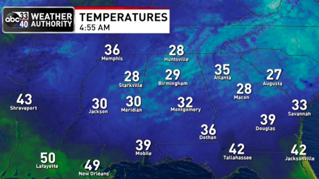
DRY THROUGH FRIDAY: Temperatures are below freezing over about the northern two-thirds of Alabama this morning, but we expect another nice warm-up today. With a sunny sky, most communities will see a high in the mid 50s this afternoon, right at seasonal averages for mid-January in Alabama. Dry weather continues Thursday and Friday with highs in the mid to upper 50s and a good supply of sunshine both days.
MESSY WEEKEND: Clouds will increase Saturday ahead of a weather system that will bring rain into the state by mid to late afternoon. Rain will be widespread Saturday night, with amounts of one-half to 1 inch likely statewide. Some thunder is possible, but no severe storms are expected.
Colder air rolls into the state Sunday; temperatures will likely fall into the 30s by afternoon with a brisk north wind. There is a chance we will see snow showers over about the northern third of the state in the colder air, but typically in this scenario we don’t have any serious travel impact. While some light accumulation is possible in grassy areas, temperatures should be a little above freezing and roads will remain wet through the afternoon. Snow showers will end Sunday evening, and we will have to watch for patchy black ice on bridges Sunday night as temperatures will go below freezing by then.
Of course, the forecast could change as we get closer to the weekend. But, for now most of the precipitation with the weekend system in Alabama will come from rain, with potential for the snow showers Sunday on the back side of the system. The bigger winter weather issues will come northeast of Alabama, across parts of the Carolinas, where snow and ice is likely in many areas.
NEXT WEEK: Monday will be cold and dry with highs in the 40s; then we expect seasonal temperatures for the rest of the week, with highs mostly in the 50s. Some rain could return toward the end of the week.
 ON THIS DATE IN 1982: A catastrophic ice storm unfolded across much of Alabama. After a period of very cold air with single-digit temperatures, a winter storm brought some snow, but mostly freezing rain to the state. The precipitation arrived about eight hours earlier than anticipated in the Birmingham area and quickly changed over to a mix of freezing rain and sleet that turned roads into skating rinks. Thousands of motorists had to abandon their vehicles on roads and hike home or spend the night in shelters. Brookwood Village mall became a huge shelter. So many wrecks occurred that the Birmingham Police Department could not answer the calls for accident investigation.
As temperatures hovered near the freezing mark through the night, freezing rain created a thick coating on all exposed objects. Trees snapped, pulling down power lines and putting as many as 750,000 Alabamians in the dark. A state of emergency was declared in Alabama and National Guard Armories were opened to serve as shelters. Some people had no power for weeks; timber damage in the state was extensive.
Twenty Alabamians were dead and another 300 injured, and damage totaled $78 million.
BEACH FORECAST: Click here to see the AlabamaWx Beach Forecast Center page.
WEATHER BRAINS: You can listen to our weekly 90-minute show any time on your favorite podcast app. This is the show all about weather featuring many familiar voices, including the meteorologists at ABC 33/40.
CONNECT: You can find me on the major social networks:
For more weather news and information from James Spann and his team, visit AlabamaWx.


