Bill Murray: Boring weather ahead for Alabama, but we will take it
FIRST TORNADO FATALITY: Our state produced the first U.S. tornado fatality of 2022. That fatality occurred in the EF2 tornado that struck Thursday afternoon near Sawyerville in Hale County. The tornado cut a nearly 26-mile path across Greene and Hale counties. It struck Sawyerville around 2 p.m., meaning there was a full 10 minutes of lead time with the Tornado Warning, and the upstream warning for Sumter and Greene counties gave an extra 42 minutes on top of that.
CHILLY START: It is a cold morning across north and central Alabama, with temperatures in the middle 20s. Some of the normally colder spots in north Alabama might actually be down into the high teens. A gusty north wind is making it feel colder. That wind will die down this morning, but despite full sunshine, the mercury will not recover very well. Highs across the north will struggle to reach 40 degrees, while readings across central Alabama will top out only in the mid and upper 40s.
BORING WEEK AHEAD: We will take boring in place of the severe weather we saw earlier this week. Persistent troughiness will cover the eastern United States, including Alabama, keeping us generally dry and cool. A shortwave trough swinging through Thursday night and early Friday may find just enough moisture to wring out a little light rain across the area. Temperatures will be cool all week, but next Saturday should see readings in the 60s again.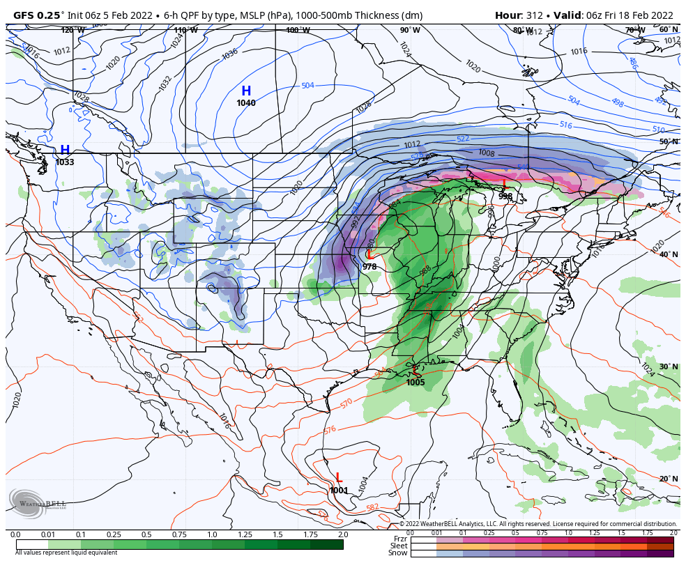
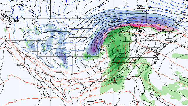
VOODOO TERRITORY: The Global Forecast System is hinting at a strong storm system moving out of the Plains on Thursday, Feb. 17, into Friday, Feb. 18. This one has a severe weather look about it, with a deep, negatively tilted trough and strong low pressure over Missouri. Early indications are that there could be a decent amount of instability with this system and the wind fields could be quite strong. It will be one to keep an eye on as we go through time.
BEACH FORECAST: Look for a benign week of weather along the beautiful beaches of Alabama and northwest Florida. There could be a few light showers Sunday night, but otherwise it will be dry and cool. Highs will be in the 50s and lows in the 30s and 40s through midweek. Highs will edge by in the 60s just in time for the weekend. Water temperatures are in the middle 50s.
Click here to see the Beach Forecast Center page.
NATIONALLY: There’s not much going on early this morning. Freeze and hard freeze warnings are in place across Texas, with readings this morning in the upper teens around the Dallas-Fort Worth Metroplex. But nothing like last February in the Lone Star State, thank goodness. There’s a good bit of wind over the northern Rockies and some snows across the Upper Midwest and across the Alleghanies, with some leftover snows across northern New England as well. I just saw a report of 16.1 inches of snow near Burlington, Vermont.
DANCING WITH THE STATS: A total 11.4 inches of snow at Bangor, Maine, on Friday was a record for the date, breaking the old record of 9.6 inches.
WEATHERBRAINS: This week, the panel will entertain Dr. Kandis Boyd, a pioneering meteorologist. Check out the show at www.WeatherBrains.com. You can also subscribe on iTunes. You can watch the show live at live.bigbrainsmedia.com or on James Spann’s YouTube Channel.
ON THIS DATE IN 1744: John Jeffries was born. He was a loyalist doctor during the Revolutionary War who kept some of the earliest detailed weather records in the American Colonies. We honor his memory by dedicating Feb. 5 as National Weatherperson’s Day.
For more weather news and information from James Spann, Bill Murray and other members of the James Spann team, visit AlabamaWx.


