James Spann: Weather smorgasbord for Alabama — storms, snow and cold

BUSY NIGHT AHEAD: It will be a busy night in the weather office as we have potential for severe thunderstorms over south Alabama and snow over the northern counties. This is thanks to a sharp cold front that will approach the northwest corner of the state this evening. Ahead of the front, temperatures are mostly between 68 and 75 degrees this afternoon with a mix of sun and clouds.
Here are the key messages for the next 24 hours:
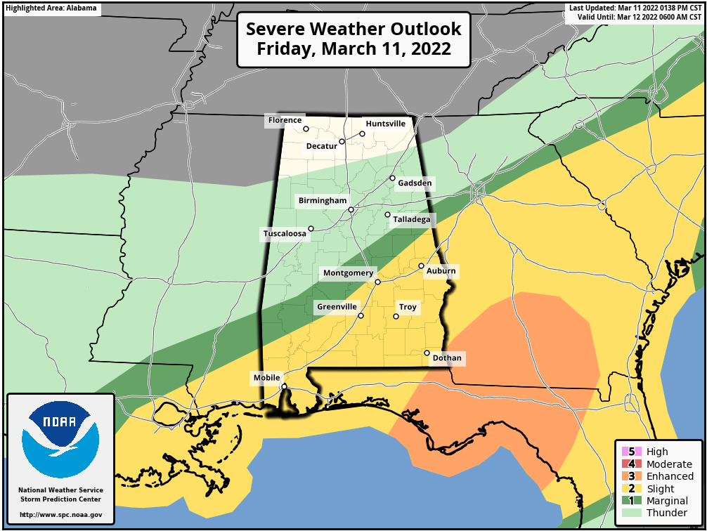
- Severe thunderstorms are possible over the southern half of the state tonight, generally between 7 p.m. and 2 a.m. Higher tornado probabilities are in the slight risk area (level 2 of 5), south of a line from Chatom to Prattville to Roanoke. Storms could also produce strong straight-line winds. A marginal risk (level 1 of 5) extends as far north as Sweetwater, Verbena and Wedowee; in this area a few strong wind gusts are possible with heavier storms that move through. Be sure you have a way of hearing severe weather warnings tonight if you are in south Alabama.
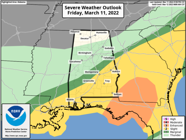
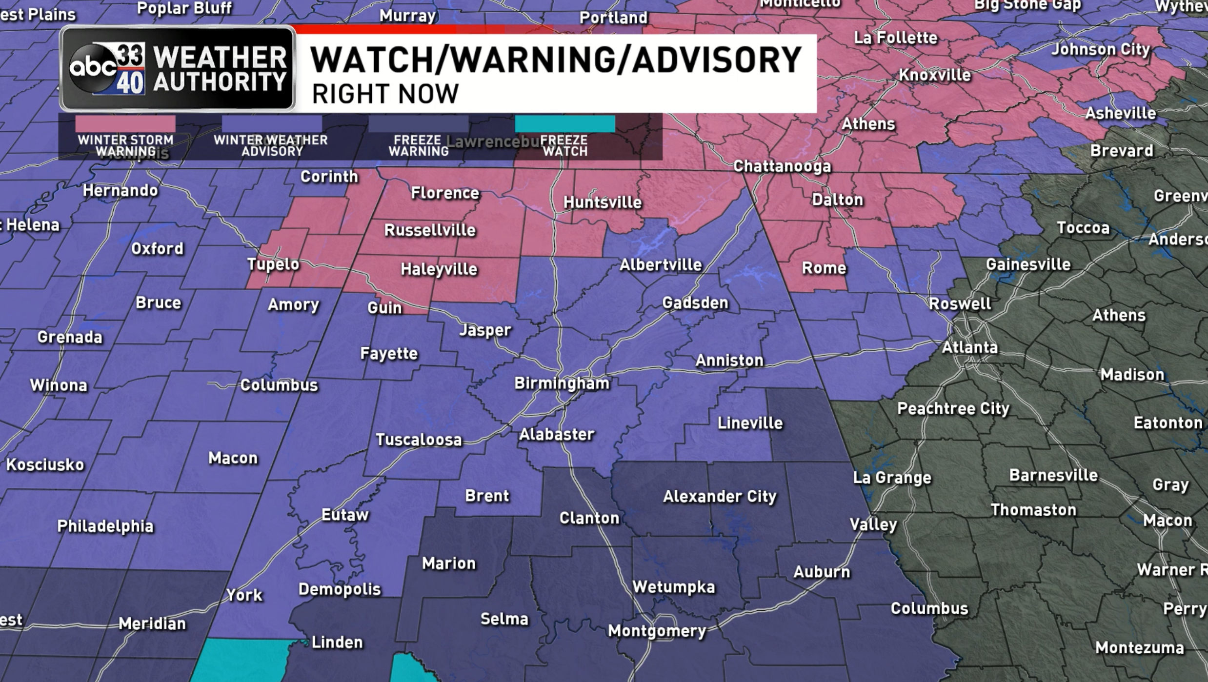
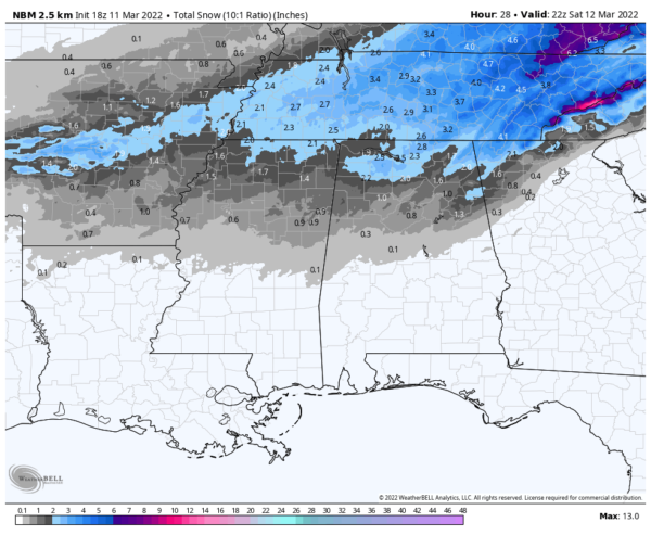
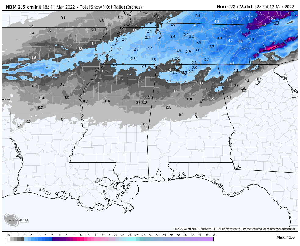
- Rain changes to snow across the northern third of Alabama late tonight. A winter storm warning remains in effect for areas north of a line from Winfield to Falkville to Scottsboro, where 2-3 inches of snow is likely on grassy areas. A winter weather advisory extends as far south as Livingston, Brent, Calera, Ashland and Heflin; amounts of one-half to 1 inch are possible in this zone.
- The change to snow could begin around Muscle Shoals as early as 9 p.m., but most of the snow will fall from midnight until 5 a.m.
- The greatest travel impact will come across the winter storm warning area, where bridges and roads will likely become icy and dangerous in many places. Patchy bridge icing is likely in the winter weather advisory area. Be very careful if you have to drive late tonight or Saturday morning.
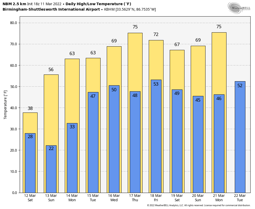
 The sky will be mostly sunny across Alabama Saturday, but temperatures won’t get out of the 30s over the northern half of the state, and an icy north wind will keep the wind chill index near freezing all day.
- Look for a low between 16 and 24 degrees by early Sunday morning over the northern half of Alabama, a very significant late-season freeze. Freezing temperatures are likely all the way down to the Gulf Coast. Sunday will be sunny with a high in the 50s as a warming trend begins.
- I am not issuing travel go or no-go opinions for tonight and Saturday morning. I possess no special knowledge or skill about future road conditions. It all depends on your specific route and risk tolerance.
NEXT WEEK: Monday will be dry with a high in the 60s, but rain returns Tuesday as an upper trough passes through. Showers could linger into part of the day Wednesday. Then we expect a sunny, mild Thursday, with a high in the 70s. Showers and storms will likely return Friday; it’s too early to know whether severe storms will be an issue with that system.
 TIME CHANGE: Remember, we go back on Daylight Saving Time this weekend. The sunset time at Birmingham Sunday evening will come at 6:53 p.m.
ON THIS DATE IN 1888: The Great Blizzard of 1888 paralyzed the East Coast from the Chesapeake Bay to Maine March 11-14. The blizzard dumped as much as 55 inches of snow in some areas, and snowdrifts of 30 to 40 feet were reported. An estimated 400 people died from this blizzard.
BEACH FORECAST: Click here to see the AlabamaWx Beach Forecast Center page.
WEATHER BRAINS: You can listen to our weekly 90-minute show any time on your favorite podcast app. This is the show all about weather featuring many familiar voices, including the meteorologists at ABC 33/40.
CONNECT: You can find me on the major social networks:
For more weather news and information from James Spann and his team, visit AlabamaWx.


