James Spann: Clearing in Alabama today; dry through Monday
James Spann forecasts improving weather, some sun for Alabama from Alabama NewsCenter on Vimeo.
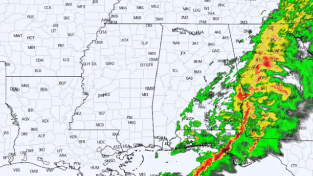
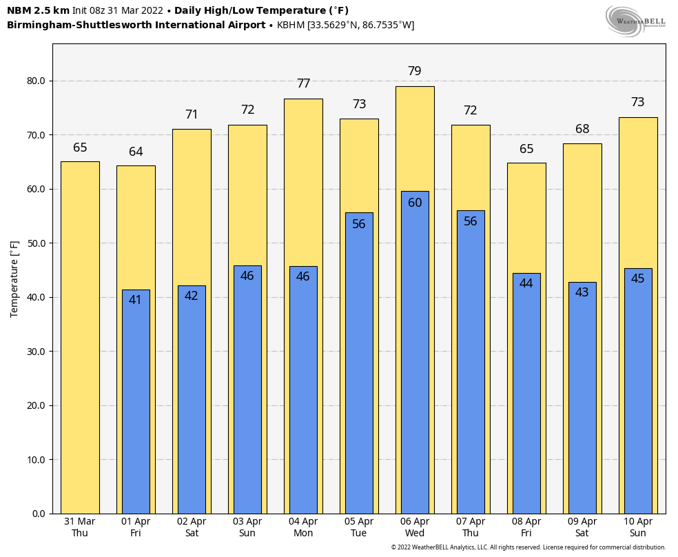
CALMER DAY: The heavier storms have moved out of the southeast corner of Alabama early this morning. Today will be much calmer, with a clearing sky and highs in the mid 60s. Tonight will be clear and pretty cold for the end of March; temperatures will drop into the 35- to 40-degree range early Friday morning. Colder pockets could see a touch of light frost.
FRIDAY THROUGH THE WEEKEND: Look for mostly sunny days and fair nights. The exception is the immediate Gulf Coast, where a few showers could show up Saturday. The high will be between 65 and 68 degrees Friday, followed by low 70s Saturday and mid 70s Sunday.
NEXT WEEK: The weather will stay dry Monday, but rain and thunderstorms will return to the state Tuesday. Global models show some surface-based instability available, so strong storms will be possible, but it is a little too early to define a severe weather threat. Showers could linger into part of the day Wednesday; then we will be dry and colder Thursday and Friday. There is also some evidence parts of north and central Alabama could see a frost or freeze threat toward the end of the week.
WEDNESDAY/LAST NIGHT: As expected, it was a very rough weather day for Alabama. Tree and power-line damage was reported in just about every county during the day due to strong gradient winds (not related to thunderstorms); the peak gust at Birmingham during the day was 58 mph. Many fires were started due to sparks from trees falling on power lines; those fires spread quickly due to the strong winds.
Tornadoes touched down last night in many counties, including Pickens, Marengo, Bibb, Shelby, Perry, Choctaw, Mobile and Baldwin. National Weather Service storm survey teams will begin their work today to determine the number of tornadoes and their rating on the Enhanced Fujita scale. Some injuries were reported, but no fatalities had been reported as of early this morning.
ON THIS DATE IN 1973: A devastating F4 tornado took a nearly continuous 75-mile path through north-central Georgia, causing more than $104 million in damage. Athens was heavily damaged.
ON THIS DATE IN 2020: An EF-2 tornado passed just south of Eufaula. It intensified as it crossed U.S. 431 and was captured on video, with the most significant damage occurring in the Country Club of Alabama neighborhood along the south side of Pebble Beach Drive. Large sections of roofs were removed from a few well-built residences with collapse of some exterior walls. The tornado crossed the Walter F. George Reservoir along the Chattahoochee River and continued into Quitman County in Georgia.
BEACH FORECAST: Click here to see the AlabamaWx Beach Forecast Center page.
WEATHER BRAINS: You can listen to our weekly 90-minute show any time on your favorite podcast app. This is the show all about weather featuring many familiar voices, including the meteorologists at ABC 33/40.
CONNECT: You can find me on the major social networks:
For more weather news and information from James Spann and his team, visit AlabamaWx.


