James Spann: Strong to severe storms likely in Alabama later today
James Spann forecasts another stormy day for Alabama from Alabama NewsCenter on Vimeo.
ANOTHER ACTIVE DAY: The weather is quiet across Alabama early this morning, but showers and storms will form this afternoon ahead of a cold front, and those storms could be strong to severe. Unlike Tuesday, all of Alabama will have an unstable air mass in place this afternoon.
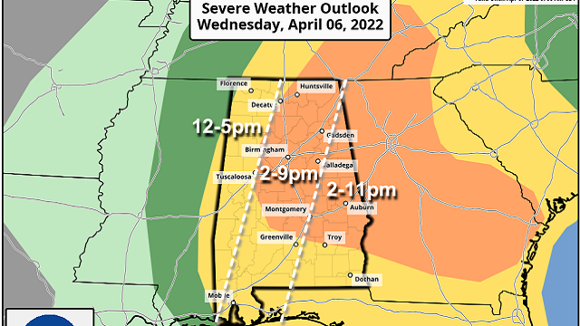
The Storm Prediction Center has defined an enhanced risk (level 3 out of 5) of severe thunderstorms for much of central and east Alabama, with a slight risk (level 2 of 5) for the rest of the state.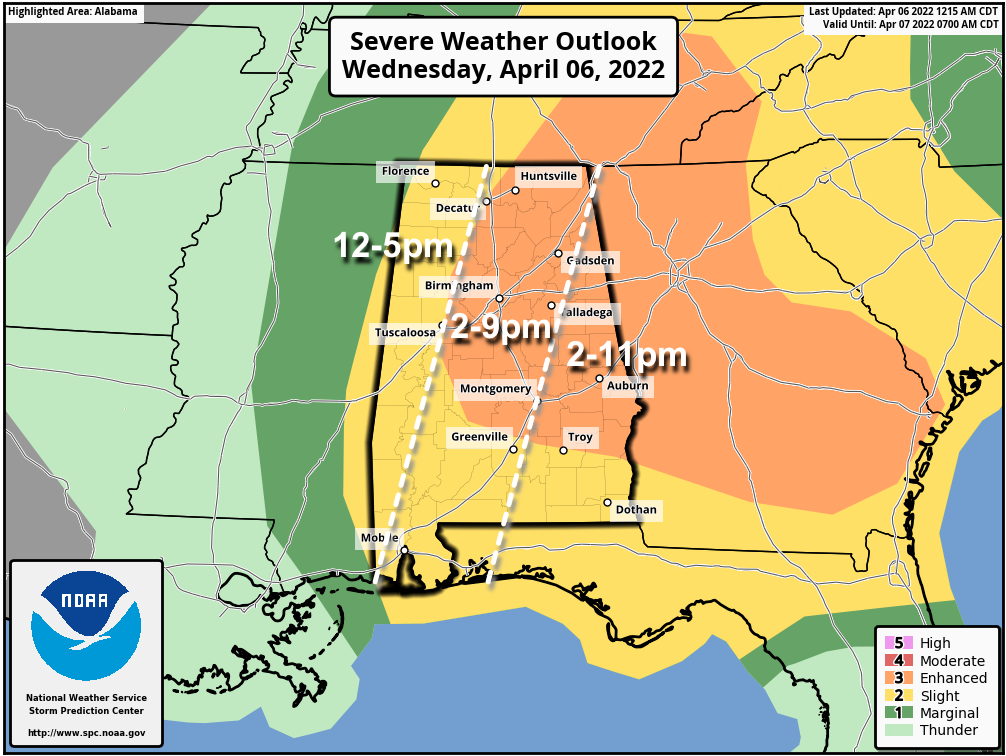 The broad window for the stronger thunderstorms will come from about noon to 9 p.m. with the activity forming initially over the western counties, followed by an eastward progression. The main threat will come from strong winds and hail; wind profiles aren’t really favorable for tornado development. Still, a brief tornado or two can’t be totally ruled out where small-scale boundaries are involved.
Storms will end from northwest to southeast early tonight as the cold front pushes through. It’s another day to be weather aware and pay attention to warnings if they are needed. These type days are very common around here in April.
Thursday and Friday will feature a significant cooling trend; with a partly sunny sky the high will be in the mid 60s Thursday, followed by mid to upper 50s Friday. The northeast corner of the state could see a few showers Friday, but most of the state will be dry.
LATE-SEASON FROST/FREEZE: We are forecasting lows well down in the 30s both Saturday and Sunday mornings over the northern half of Alabama, with potential for widespread frost, and freezing temperatures for colder spots both mornings. Growers will need to monitor temperature forecasts. This type of cold snap is very common in early April, and the reason I always advise people to wait until April 15 to plant anything that might be harmed by frost or a freeze.
Otherwise, the weekend will feature a good supply of sunshine. The high will be between 56 and 61 degrees Saturday, followed by low 70s Sunday as a warming trend begins.
NEXT WEEK: Forecast confidence is fairly low in the details, but the main threat of severe storms during the week will likely be well to the west of Alabama, across parts of Texas, Oklahoma, Kansas and Arkansas. We could see a few showers on a day or two, but no major rain events are expected thanks to an upper ridge over the region.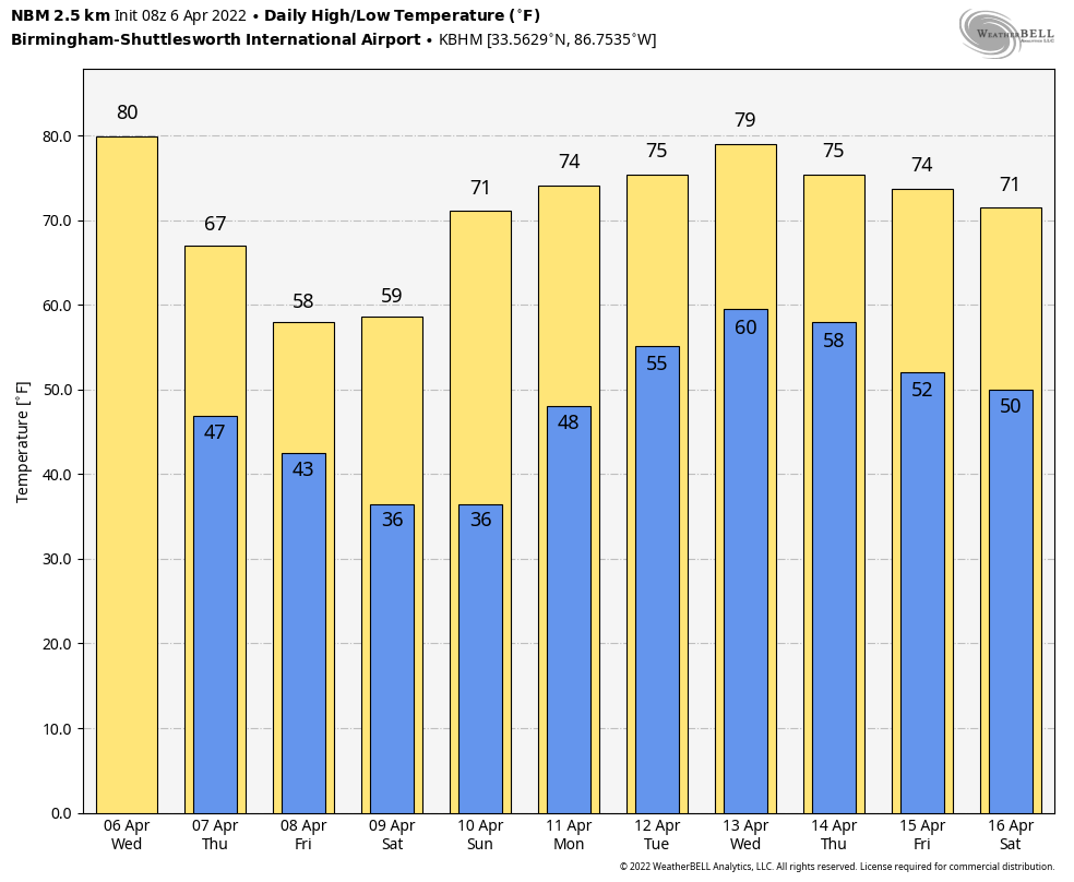 ON THIS DATE IN 2007: In Cleveland, Ohio, April 6-9, the opening-season series between the Indians and Minnesota Twins was wiped out by a snowstorm and a cold snap. The Indians led 4-0 when their home opener was called off by umpires because of heavy snow. The grounds crew who tried to make the field playable with backpack blowers and brooms spent more time on the field than the players during nearly three hours of stoppages. About a foot of snow remained on the ground April 9.
BEACH FORECAST: Click here to see the AlabamaWx Beach Forecast Center page.
WEATHER BRAINS: You can listen to our weekly 90-minute show any time on your favorite podcast app. This is the show all about weather featuring many familiar voices, including the meteorologists at ABC 33/40.
CONNECT: You can find me on the major social networks:
For more weather news and information from James Spann and his team, visit AlabamaWx.


