James Spann: Most of Alabama stays dry today; humidity levels rise Friday
James Spann forecasts one more dry day for Alabama from Alabama NewsCenter on Vimeo.
COOL START: Here are some temperatures over north Alabama early this morning. We are enjoying a touch of fall in the air on this first morning of September:
- Cullman — 57
- Oneonta — 58
- Haleyville — 59
- Huntsville — 61
- Gadsden — 61
- Scottsboro — 61
- Chelsea — 62
- Decatur — 62
- Sylacauga — 62
- Talladega — 62
- Muscle Shoals — 62
- Pell City — 63
- Hueytown — 63
- Anniston — 64
- Birmingham — 67
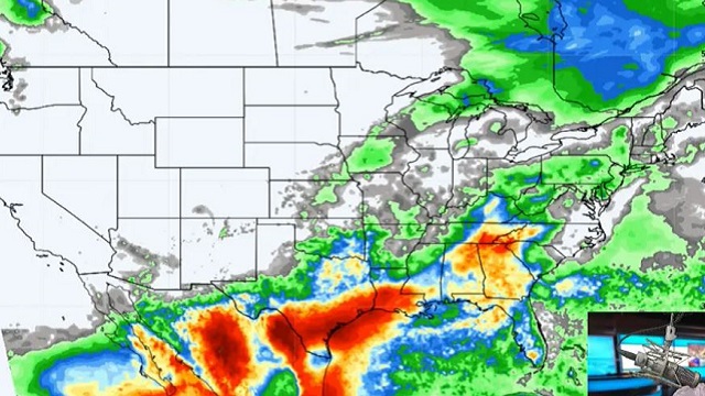
Expect another mostly sunny day ahead with a high in the low 90s; showers will be confined to the southern quarter of the state, and even there most places will remain rain-free.
FRIDAY AND THE HOLIDAY WEEKEND: Moisture levels rise Friday and we will bring back the chance of a few scattered showers and storms during the afternoon and evening; odds of any one spot getting wet are 30-40%, and the high will be between 87 and 90 degrees with a mix of sun and clouds.
Over the weekend, the weather will be rather unsettled, with scattered to numerous showers and thunderstorms Saturday through Monday. This doesn’t mean a washout, and the sun will peek out at times. Most (but not all) of the showers will come from noon to midnight, and highs will be in the low to mid 80s. There’s no way of knowing in advance the exact location and timing of the showers; you just have to watch radar trends if you have an outdoor event planned. Rain amounts of 1-2 inches are likely over these three days for most places across Alabama.
NEXT WEEK: Showers become fewer in number Tuesday through Friday as an upper ridge builds; expect partly sunny days with a few scattered showers and storms during the afternoons and evenings. Highs will be mostly in the mid to upper 80s.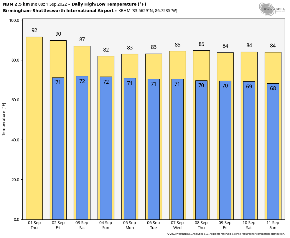 TROPICS: Tropical Depression Five has formed in the North Atlantic; it could become a hurricane over the next few days, but it will remain far from land.
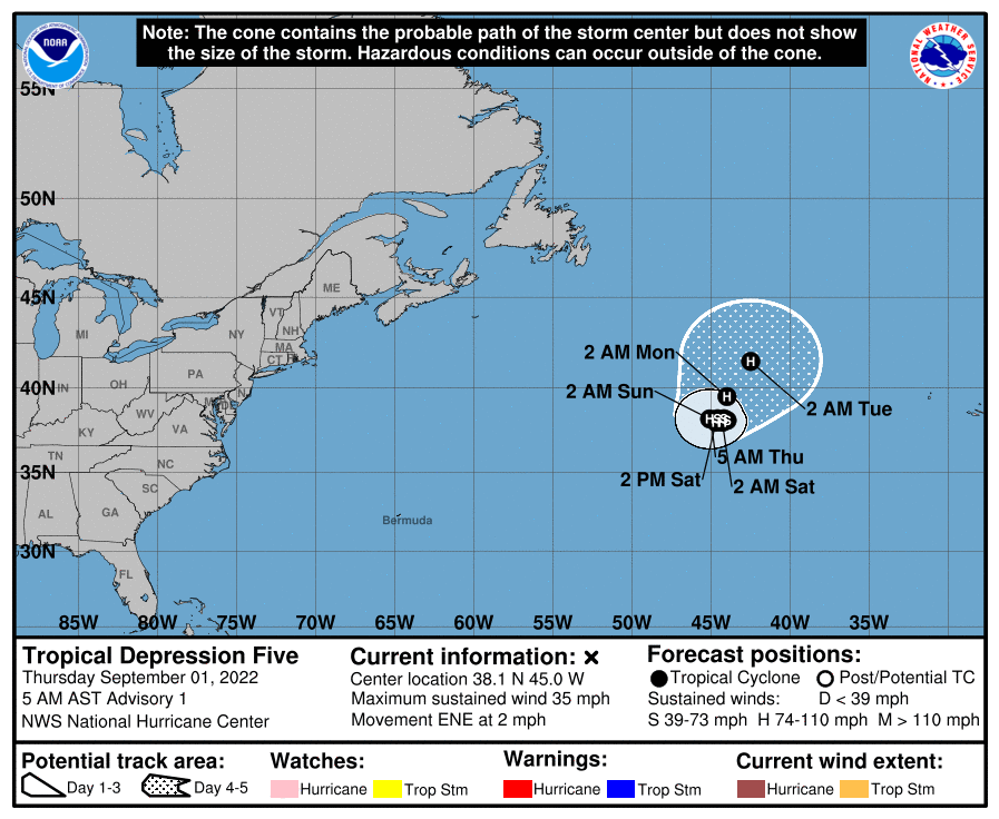 The National Hurricane Center is monitoring two other tropical waves. One is in the Atlantic several hundred miles east of the Leeward Islands; this one has a high chance of becoming a tropical depression or storm over the next few days, but it will turn north and then northeast over the open Atlantic well east of the U.S. The other wave is in the far eastern Atlantic; it has a brief window for some development before environmental conditions become unfavorable. If by chance anything develops here, it will also remain far from land.
No tropical systems will be anywhere close to the U.S. for at least the next five to seven days.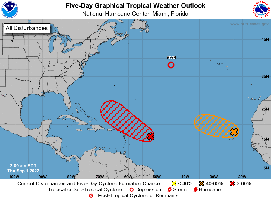 FOOTBALL WEATHER: UAB kicks off its season tonight, hosting Alabama A&M at Protective Stadium in downtown Birmingham (7 p.m. kickoff). The sky will be clear with temperatures falling from near 83 at kickoff into the 70s by the second half.
Auburn begins its season Saturday, hosting Mercer at Jordan-Hare Stadium (6 p.m. kickoff). A shower or storm is very possible during the game; the sky will be mostly cloudy and the temperature about 81 at kickoff and upper 70s for most of the game.
Alabama also plays Saturday, hosting Utah State at Bryant Denny Stadium (6:30 p.m. kickoff). A passing shower or storm is a distinct possibility; otherwise it will be a warm, humid night with temperatures falling from the low 80s at kickoff into the 70s for most of the game.
For all the other games in the state Saturday, scattered to numerous showers and storms will be around, but the day won’t be a washout. Take the rain gear.
ON THIS DATE IN 1859: One of the largest geomagnetic storms on record was underway. Known as the “Carrington Event” (after British astronomer Richard Carrington, who recorded the solar flare), it was the most intense geomagnetic storm in recorded history, peaking Sept. 1-2 during solar cycle 10. It created strong auroral displays that were reported globally and caused sparking and even fires in multiple telegraph stations. A geomagnetic storm of this magnitude occurring today would cause widespread electrical disruptions, blackouts and damage due to extended outages of the electrical power grid.
ON THIS DATE IN 1974: Lt. Judy Neuffer became the first woman to fly a Hurricane Hunter aircraft through the eye of a hurricane.
BEACH FORECAST: Click here to see the AlabamaWx Beach Forecast Center page.
For more weather news and information from James Spann and his team, visit AlabamaWx.


