James Spann: Alabama stays dry through Saturday
SEVERE CLEAR: Temperatures are about 15 degrees cooler across Alabama this afternoon. With sunshine in full supply, most communities are between 78 and 83 degrees. Tonight will be clear and cool, with a low between 55 and 60 degrees.
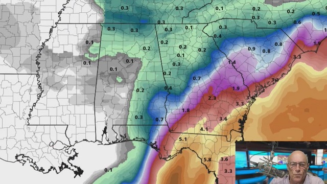
THE ALABAMA WEEKEND: Saturday will be another sunny day with a high in the mid 80s. On Sunday, we will bring in some risk of showers over the northern half of the state with another cold front approaching. Moisture will be limited and rain amounts will be light. Otherwise, look for a mix of sun and clouds Sunday with a high between 83 and 86 degrees.
NEXT WEEK: The week looks dry and very pleasant, with highs mostly between 75 and 80 degrees and lows in the 50s. Many communities over north Alabama could reach the mid to upper 40s early Wednesday morning.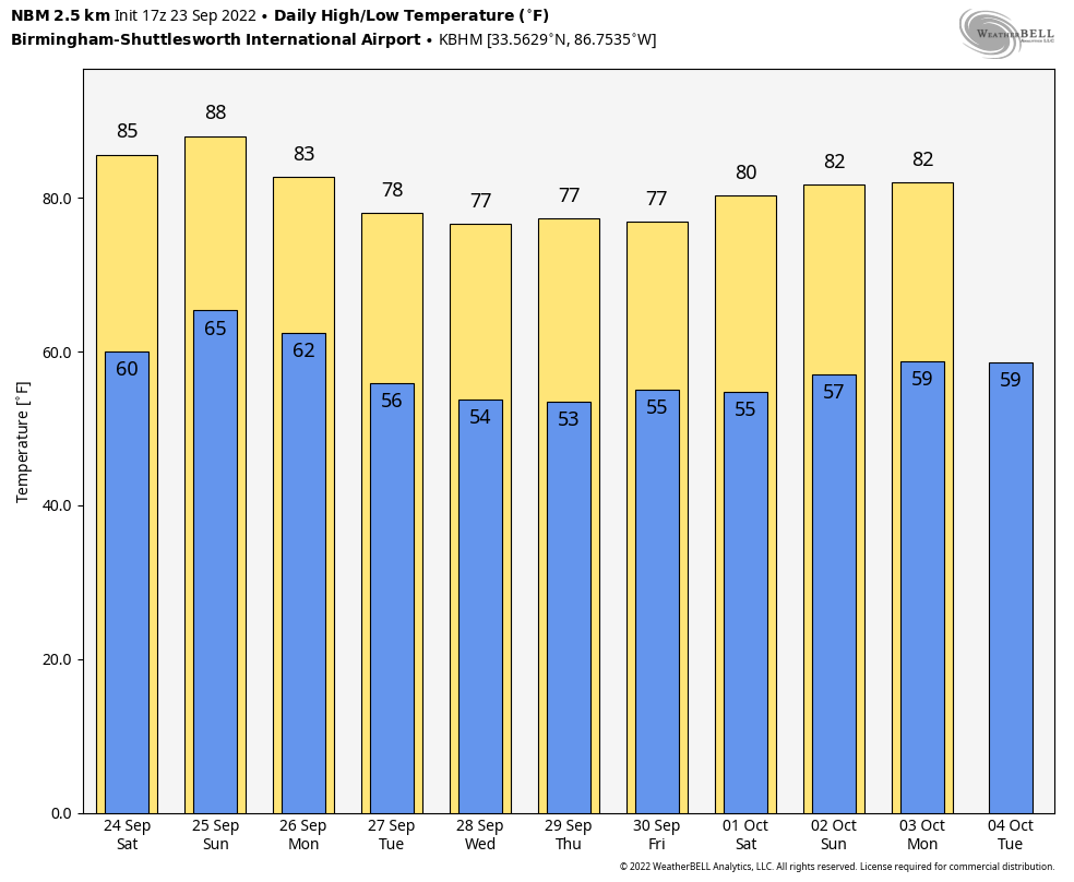
FOOTBALL WEATHER: Expect perfect weather for high school games across the state tonight; it will be clear and very pleasant with temperatures falling into the 60s.
Saturday, Auburn hosts Missouri at Jordan-Hare Stadium (11 a.m. kickoff); the sky will be sunny with temperatures rising from near 77 at kickoff into the low 80s by the second half.
Alabama will host Vanderbilt at Bryant Denny Stadium Saturday evening (6:30 kickoff); the sky will be clear with temperatures falling from 80 degrees at kickoff into the low 70s by the final whistle.
TROPICS: Hurricane Fiona, with winds of 130 mph, is headed for the Canadian Maritimes. Hurricane conditions are expected in Nova Scotia by Saturday morning.
Tropical Storm Gaston remains near the Azores; it will remain far from any other land mass over the next five days in the high latitudes of the Atlantic.
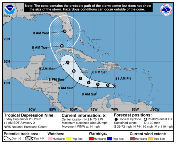
In the Caribbean, we are watching Tropical Depression Nine. Here are some key messages:
- The depression remains highly sheared; visible satellite imagery and data from an Air Force Reserve Hurricane Hunter aircraft indicate the center of the system is still exposed to the east of the associated deep convection. The center also appears a bit elongated, with a couple of low-level swirls evident in satellite imagery that appear to be rotating around a mean center.
- Shear should relax Saturday afternoon and the depression should be a tropical storm by Saturday night.
- The name could be Hermine or Ian. A new depression has also formed in the far eastern Atlantic; it is also expected to become a tropical storm.
- There is good model agreement, and the National Hurricane Center track puts the system into south Florida, around Fort Myers, Wednesday morning as a major, Category 3 hurricane.
- The main impact (from wind and rain) will be across the Florida Peninsula (not the panhandle). It is still too early for an impact statement for any given point or city, but places like Tampa, St. Petersburg, Orlando, Daytona Beach, Key West, Miami and Fort Lauderdale will likely be dealing with lots of wind and rain by the middle of next week.
- Those along the Florida Gulf Coast from Tampa Bay south to Key West need to be prepared for hurricane conditions in five days or so.
- Alabama and the central Gulf Coast (Gulf Shores to Panama City Beach) will be on the dry, west side of the circulation.
- As always, this forecast could change, so stay tuned for updates.
ON THIS DATE IN 1975: Hurricane Eloise made landfall on the Florida coast near Fort Walton Beach at Category 3 strength. Eloise generated wind gusts of 155 mph, which demolished hundreds of buildings in the area. The storm’s severe winds, waves and storm surge left numerous beaches, piers and other coastal structures heavily impaired. Wind-related damage extended into inland Alabama and Georgia.
BEACH FORECAST: Click here to see the AlabamaWx Beach Forecast Center page.
For more weather news and information from James Spann and his team, visit AlabamaWx.


