Scott Martin: Nice, warm Saturday for Alabama; Ian forms and begins his trek to the Gulf of Mexico
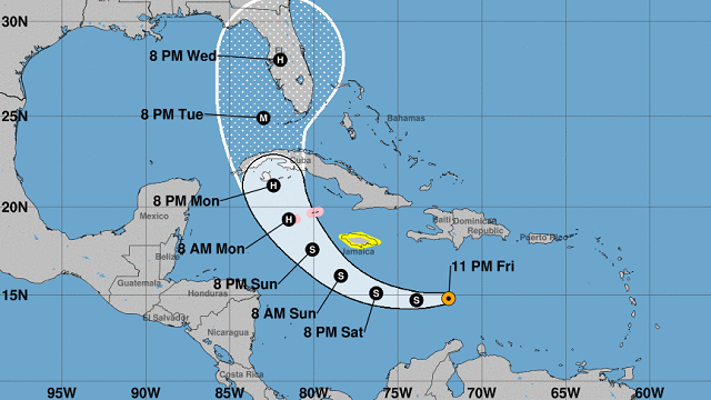
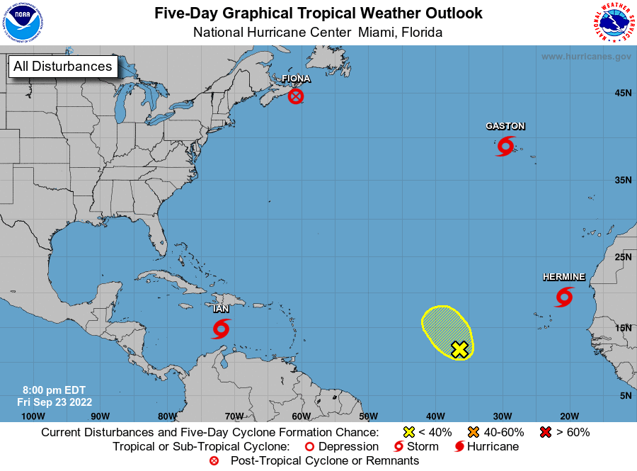
TROPICAL STORM IAN: As of 10 p.m. Friday, Ian was around 385 miles south of Kingston, Jamaica, and was moving west-northwest at 12 mph. Maximum sustained winds were at 40 mph, but Ian is expected to become a Category 3 hurricane before making a forecast landfall on the Gulf Coast of the Florida peninsula by Wednesday night. A hurricane watch is up for the Cayman Islands and a tropical storm watch is up for Jamaica.
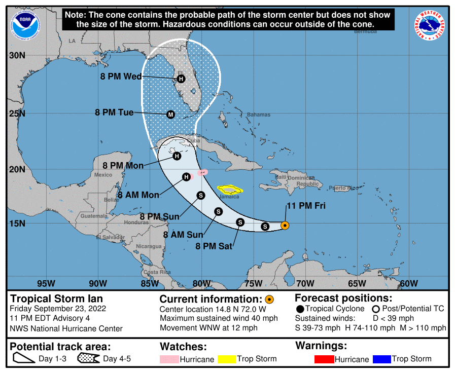
Ian is expected to produce heavy rainfall, instances of flash flooding and possible mudslides in areas of higher terrain, particularly over Jamaica and Cuba. Hurricane conditions are possible in the Cayman Islands by early Monday, with tropical storm conditions possible by late Sunday. Tropical storm conditions are possible in Jamaica on Sunday. Early next week, Ian is forecast to move near or over western Cuba as a strengthening hurricane and then approach the Florida peninsula at or near major hurricane strength, with the potential for significant impacts from storm surge, hurricane-force winds and heavy rainfall.
THE ALABAMA WEEKEND: Saturday will be very nice but very warm, with tons of sunshine and very little in the number of clouds. After a nice morning with lows in the lower 50s to the lower 60s, afternoon highs will top out in the mid to upper 80s.
On Sunday, a front will move through the state that will bring just enough moisture to destabilize the atmosphere for a few isolated to scattered showers to form during midmorning through the afternoon. Highs will stay warm, mid 80s to the lower 90s.
NEXT WEEK: Drier air and cooler temperatures will start to filter into the state on Monday, but we’ll have to wait one more day for it to feel like “true fall.” Highs will be throughout the 80s. Tuesday is going to be what you expect to see for fall in Alabama — sunny skies with a little breeze at times and highs in the mid 70s to the mid 80s.
Wednesday will be much the same, except for even cooler temperatures, with highs in the lower 70s to the lower 80s. Thursday is going to be a near-exact copy — sunny skies with highs in the mid 70s to the lower 80s. And on Friday, highs will remain in the mid 70s to the lower 80s, but we’ll have a few clouds move across the state from the western side of Ian and maybe a few showers along the Alabama-Georgia state line.
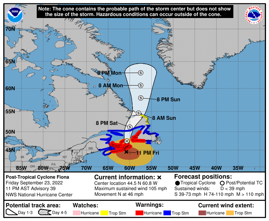
THE REST OF THE TROPICS: Post-Tropical Cyclone Fiona continues to race northward at 46 mph and will be moving across extreme eastern Canada. Winds have dropped to 105 mph and will continue to weaken over the next three to four days until dissipation. Hurricane and tropical storm warnings are in effect for much of Atlantic Canada. Large swells generated by Fiona are expected to cause life-threatening surf and rip-current conditions along much of the U.S. East Coast, the northwestern Bahamas, Bermuda and Atlantic Canada during the next couple of days.
Tropical Storm Gaston had winds at 60 mph and was moving southwest as of 10 p.m. Friday. Tropical storm conditions, including heavy rainfall, are expected over portions of the western and central Azores Saturday. This rainfall may result in landslides and flooding. Gaston is expected to become post-tropical by the time you read this.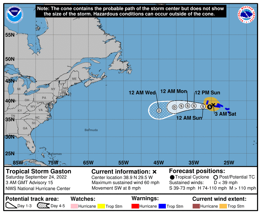
Tropical Storm Hermine continues to move slowly northward, potentially weakening back to a depression by late Saturday or early Sunday morning. Rainfall totals of 2-6 inches over the Canary Islands through this weekend are possible due to a combination of a mid-latitude trough and moisture from the cyclone. This rainfall could cause some flash flooding in areas of higher terrain.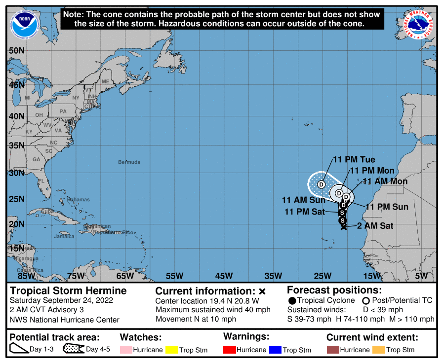
Finally, showers and thunderstorms remain disorganized in association with a broad area of low pressure several hundred miles west-southwest of the Cabo Verde Islands. Despite unfavorable upper-level winds, some slow development of this system is possible over the next several days while it drifts northwestward or northward over the central tropical Atlantic. The National Hurricane Center gives it a low chance of becoming a depression within the next five days.
.ON THIS DATE IN 1985: The central pressure of Hurricane Gloria bottomed out at 918.6 millibars (27.13 inches) in the western Atlantic. No previous hurricane on record in this part of the Atlantic had ever been this intense. Winds at the time as recorded by a reconnaissance aircraft were measured sustained at 156 mph. The media immediately declared Gloria the “killer storm of the century” and basically had the entire East Coast of the U.S. preparing for atmospheric Armageddon.
For more weather news and information from James Spann, Scott Martin and other members of the James Spann team, visit AlabamaWx.


