James Spann: Line of strong to severe storms to pass through Alabama this afternoon, evening
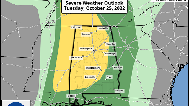
RADAR CHECK: The line of strong storms was near the Alabama-Mississippi state line at 1 p.m.; it will sweep across the state over the next six to eight hours. The Storm Prediction Center maintains a slight risk (level 2 out of 5) of severe storms for much of the state — areas west of a line from Fort Payne to Greenville to Grove Hill. The other parts of east and south Alabama are in a marginal risk (level 1).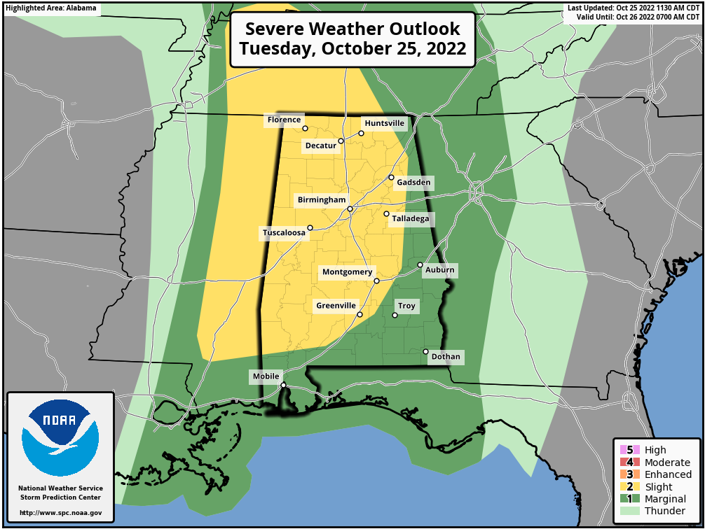 TIMING: The core threat will come from about 2 until 8 p.m. Storms will weaken over east Alabama after 8 p.m. in a more stable air mass. A severe watch will likely be needed soon for parts of west Alabama.
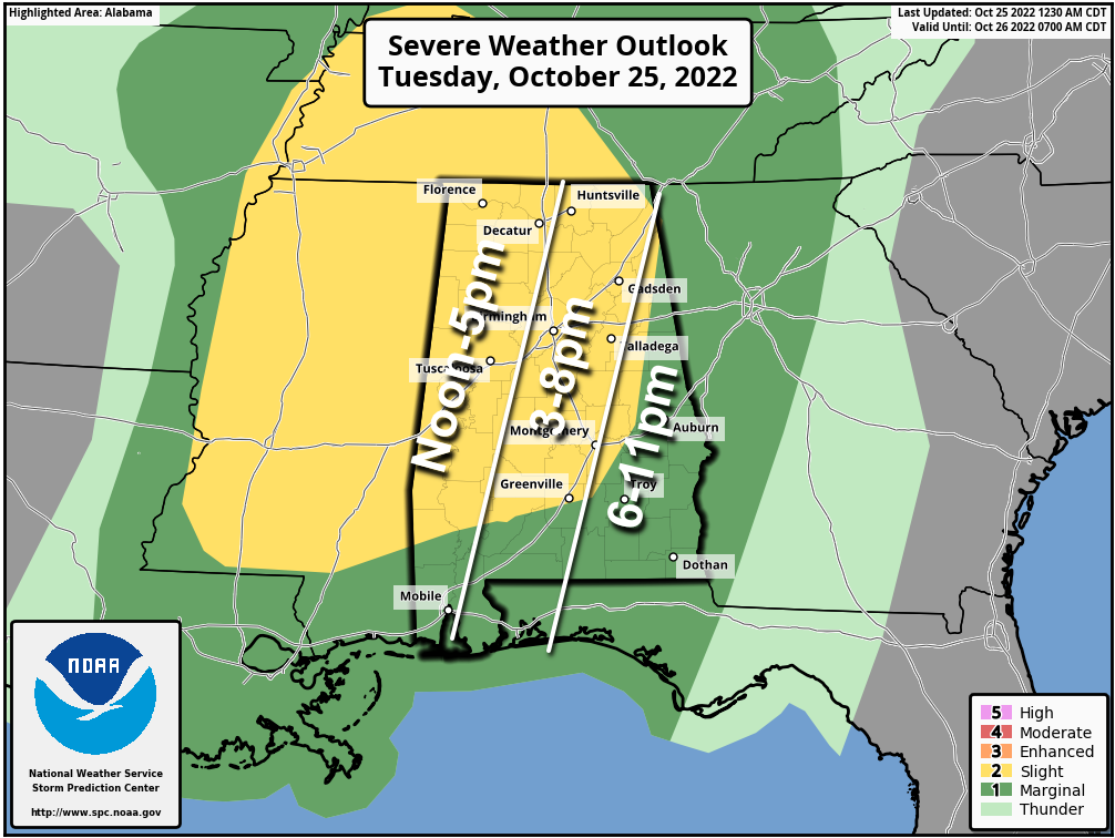 THREATS: The main concern is from strong, potentially damaging straight-line winds, but a couple of isolated tornadoes are possible as well. The highest tornado threat is over the western half of the state, where instability values are higher. Storms could also produce hail in spots. We should also mention gradient winds (not related to thunderstorms) will increase this afternoon, with gusts to 30-35 mph possible. A wind advisory has been issued for much of north Alabama.
RAIN: Storms will be moving along at a good clip, so flooding is not expected. Rain amounts of one-half to 1 inch are expected over the northern half of the state, with amounts less than one-half inch for the southern counties.
BE READY: Be sure you can hear severe weather warnings if they are needed later today. A NOAA Weather Radio is the baseline for every home and business, and be sure Wireless Emergency Alerts are enabled on your phone. Install the free ABC 33/40 Weather app. Know the safe place in your home (lowest floor, near the center of the house, away from windows), and have helmets for everyone there. If you live in a mobile home, know the location of the nearest shelter or site-built structure that is available and how to get there quickly, and have transportation.
Hopefully we will get though the event with no major problems, but you have to be ready in case you fall in a tornado warning polygon.
REST OF THE WEEK: Dry weather returns Wednesday through Friday with sunny days and fair nights. The high will be in the upper 60s Wednesday, followed by mid 70s Thursday and Friday.
THE ALABAMA WEEKEND: Rain returns to the state, but the latest model data suggests a decent part of the day Saturday will be dry. Clouds will increase, and with a few spotty showers we expect a high in the upper 60s. Sunday will be cloudy with periods of rain (not an all-day rain) and a high in the mid 60s. There’s no risk of severe storms over the weekend and probably very little thunder, with basically no surface-based instability.
NEXT WEEK: Showers could linger into the day Monday, but at this point it looks like the rain will be over by trick-or-treat time Monday night. Midweek looks dry, followed by another chance of rain by Thursday night or Friday. Highs will be in the 70s through much of the week.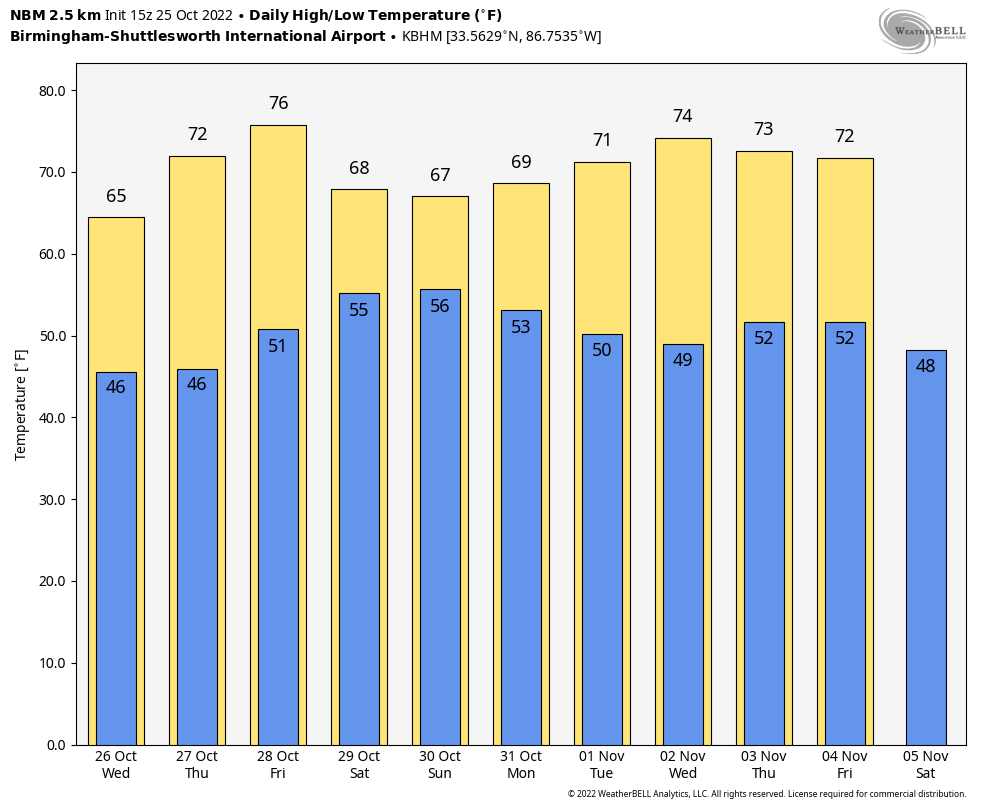 TROPICS: The National Hurricane Center is monitoring a couple of disturbances in the Atlantic, well east of the U.S. They have some potential for development but are expected to remain far from land. Another wave will be moving across the southern Caribbean later this week; for now, this has just a low chance of development.
ON THIS DATE IN 1921: A devastating Category 3 hurricane struck near Tarpon Springs, Florida, killing eight people. It was the most destructive hurricane in the Tampa Bay area since 1848. A storm surge of up to 11 feet damaged and destroyed a significant number of the structures along coastal locations from Pasco County south through southwest Florida. The highest storm surge inundated areas in downtown Tampa and Tarpon Springs. Many vessels, like the steamer “Favorite” and the “Thomas B. Garland,” were smashed against the docks by the waves.
ON THIS DATE IN 2017: The high temperature in Denver, Colorado, was 84 degrees. By the morning of Oct. 27, the temperature fell to 13 degrees, a 71-degree change.
BEACH FORECAST: Click here to see the AlabamaWx Beach Forecast Center page.
For more weather news and information from James Spann and his team, visit AlabamaWx.


