Scott Martin: Showers move into Alabama later today

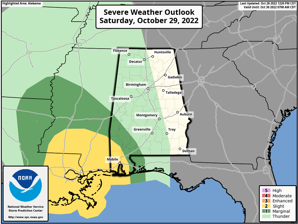
THE ALABAMA WEEKEND: Saturday will be mostly cloudy and breezy. Showers and a few rumbles of thunder will become possible over western Alabama by mid to late afternoon and eventually will move into central Alabama by the evening to late night. Much of the state will have a good chance of showers overnight.
Highs will be in the upper 60s to the mid 70s.
Showers with a rumble or two of thunder become widespread over Alabama on Sunday, but the air looks to be too stable for any stronger storms. Highs will be in the upper 60s to the upper 70s.
THE WORK WEEK: Mainly dry weather will return Monday for much of Alabama, but a few stray sprinkles may be possible over the extreme northern portions of the state. Highs will be in the upper 60s to the upper 70s. Trick-or-treat time will be dry with clearing skies. Temperatures will range from the lower to mid 60s at 7 p.m., down to the upper 50s to the lower 60s by 10 p.m.
Tuesday will be nice overall as skies will be mostly sunny and highs in the 70- to 80-degree range.
A shortwave will move across the state on Wednesday that will bring a few showers during the morning before we dry out for the afternoon and evening. Highs will be in the 70s.
We’ll have some leftover energy from the shortwave on Thursday that may keep a few light showers in the forecast for the northeast and eastern parts of the state, especially during the afternoon. The rest of Alabama looks to stay dry. Highs will be in the mid to upper 70s.
On Friday, sunny skies return with mild to warm temperatures and highs will top out in the mid 70s to the lower 80s.
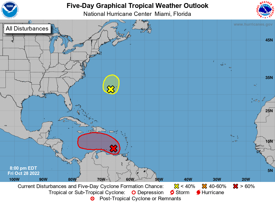
TROPICS: A broad area of low pressure over the eastern Caribbean Sea continues to produce a large area of disorganized showers and thunderstorms extending from the Windward Islands west-northwestward for several hundred miles. Environmental conditions are forecast to be conducive for gradual development over the next few days, and a tropical depression is likely to form this weekend or early next week while the disturbance moves slowly westward or west-northwestward over the central Caribbean Sea. Regardless of development, heavy rainfall is possible over portions of the Lesser Antilles, the Virgin Islands and Puerto Rico through this weekend.
Satellite data indicates that a well-defined low-pressure area about 150 miles west-southwest of Bermuda is producing a limited amount of shower and thunderstorm activity. Environmental conditions are forecast to remain only marginally conducive, and any additional development should be slow to occur over the next day or so. Development after late Saturday is not anticipated.
ON THIS DATE IN 1985: Hurricane Juan, a rather large Category 1 storm, meandered near the Louisiana coast until Oct. 31, when it finally made landfall on the Alabama coast. The slow movement of the storm resulted in excessive rain in Louisiana, with many places receiving more than 10 inches. Galliano, Louisiana, checked in with a storm total of 17.73 inches. Inland flooding combined with an 8-foot storm surge resulted in damage well over $500 million.
For more weather news and information from James Spann, Scott Martin and other members of the James Spann team, visit AlabamaWx.


