James Spann: Cooler weather ahead for Alabama

ANOTHER WARM ONE: Temperatures are in the 80s across Alabama again this afternoon, about 15-20 degrees above average for early November, and at record levels. Birmingham’s high so far is 84, which ties the record for Nov. 8 last reached in 2005. Tuscaloosa has soared to 87 degrees. But this will be the last day of the November heat wave. A dry, backdoor front will pass through tonight, pulling down colder air from the northeast.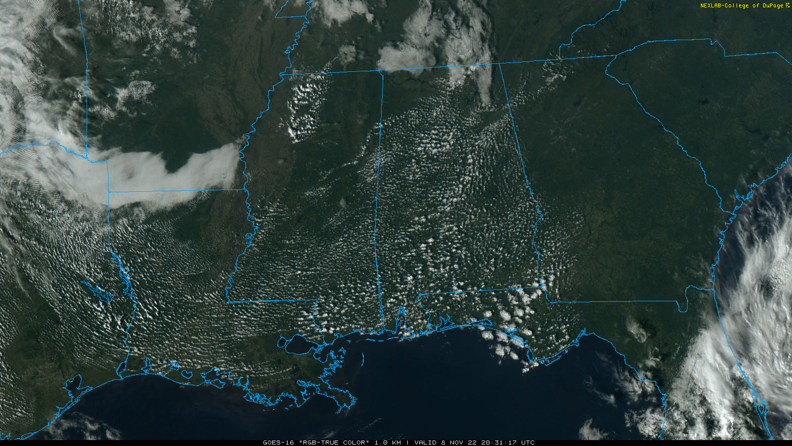 We drop into the mid to upper 40s early Wednesday morning, and the high Wednesday will be in the low 70s with a sunny sky. The day Thursday will be dry with a high between 72 and 76 degrees. Clouds will increase Thursday night, and some rain is possible over the eastern half of the state late Thursday night into early Friday morning. A north wind will increase as well, averaging 10-20 mph; this is on the far western periphery of Tropical Storm Nicole.
The best chance of rain will be east of I-65 from about 10 p.m. Thursday through 6 a.m. Friday. The sky will clear during the day with a high in the upper 60s. A gusty north wind will persist Friday.
CHILLY WEEKEND AHEAD: The coldest air so far this season will settle into the Deep South just in time for the weekend. Highs drop into the 50s Saturday and Sunday; some places across the Tennessee Valley won’t get out of the 40s Sunday afternoon. Expect a low Sunday morning between 24 and 32 degrees. The air will be dry and the sky will be clear over the weekend.
NEXT WEEK: Temperatures stay below average through the week, with highs in the 50s. The latest global model output suggests there will be some chance of rain in the Tuesday-Wednesday time frame with another cold front passing through.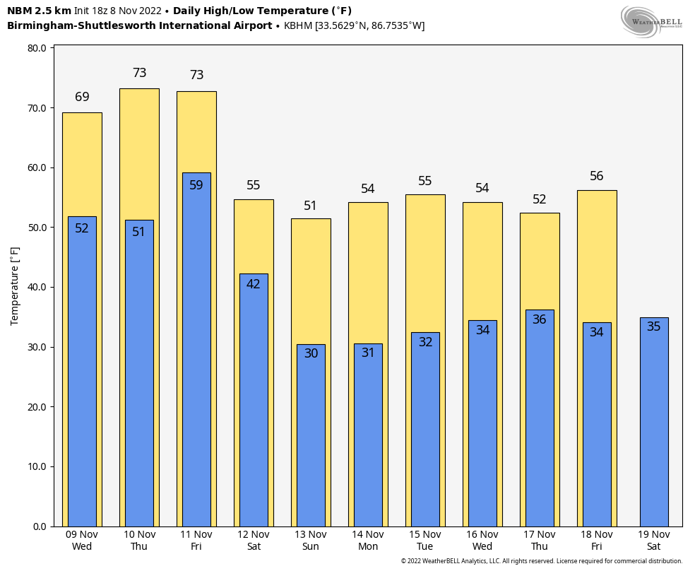 TROPICS: Tropical Storm Nicole is about 285 miles east/northeast of the northwestern Bahamas; the system is now better organized and fully tropical with winds of 65 mph.
Nicole is expected to make landfall along the Florida coast as a hurricane between Fort Lauderdale and Melbourne late Wednesday night or very early Thursday. A hurricane warning has been issued from Boca Raton to the Flagler-Volusia County line along the Florida coast.
A tropical storm warning is in effect from Hallandale Beach, Florida, to Boca Raton, Florida, and from the Flagler-Volusia County line in Florida to Altamaha Sound, Georgia, and for Lake Okeechobee.
A dangerous storm surge is expected along much of the east coast of Florida and portions of coastal Georgia, where a storm surge warning is in effect. The storm surge will be accompanied by large, damaging waves. Residents in the warning area should listen to advice given by local officials.
Do not focus on the exact track of Nicole, since it is expected to be a large storm with hazards extending well to the north of the center, outside of the forecast cone. These hazards are likely to affect much of the Florida Peninsula and portions of the southeast United States.
Nicole will produce heavy rainfall Wednesday and Thursday across the Florida Peninsula. Flash and urban flooding will be likely across portions of the peninsula along with possible renewed rises on the St. Johns River. On Friday and Saturday, flash, urban and small stream flooding will be possible in the Southeast through the Mid-Atlantic and central Appalachians.
While most of the major impact will be east of Alabama, some wind and rain are possible for the eastern counties of the state Thursday night and early Friday.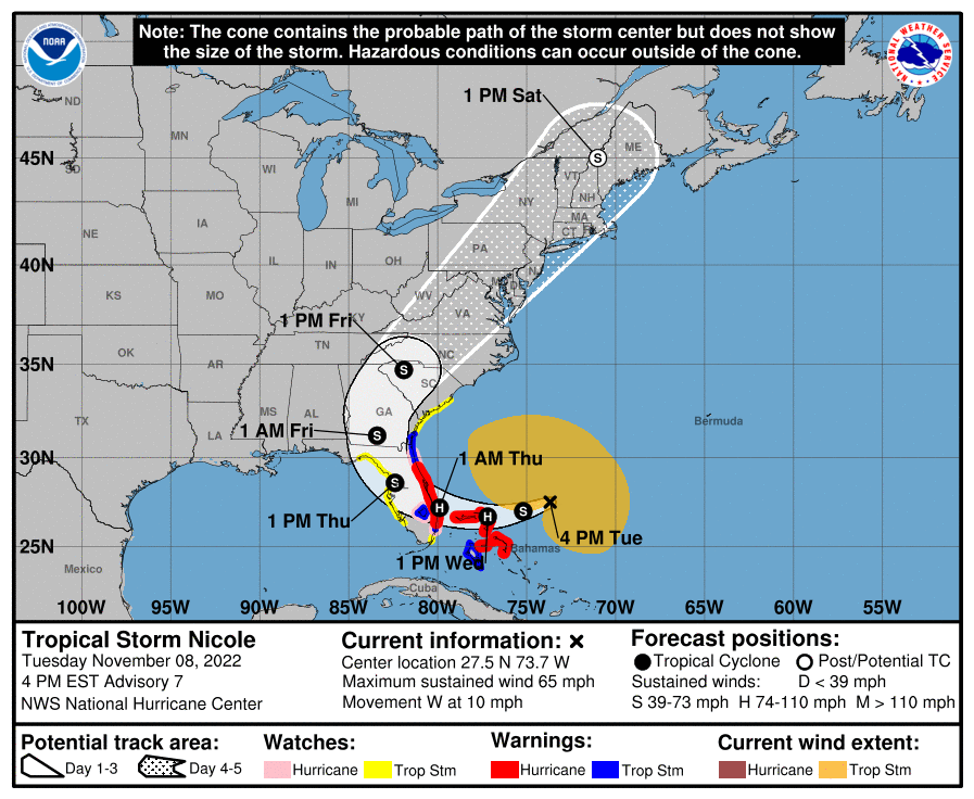 ON THIS DATE IN 1913: The Great Lakes Storm of Nov. 7-13, 1913, was a blizzard with hurricane-force winds that devastated the Great Lakes region, sinking as many as 19 ships and stranding 19 others. This storm would be the deadliest and most destructive natural disaster ever to hit the Great Lakes.
ON THIS DATE IN 1994: The 12th and final tropical cyclone of the Atlantic hurricane season formed in the southwestern Caribbean. While Hurricane Gordon was only a Category 1, it killed 1,149 people, including 1,122 in Haiti.
BEACH FORECAST: Click here to see the AlabamaWx Beach Forecast Center page.
For more weather news and information from James Spann and his team, visit AlabamaWx.


