James Spann: Active weather shifts into south Alabama later today
James Spann forecasts more rain for parts of Alabama today from Alabama News Center on Vimeo.
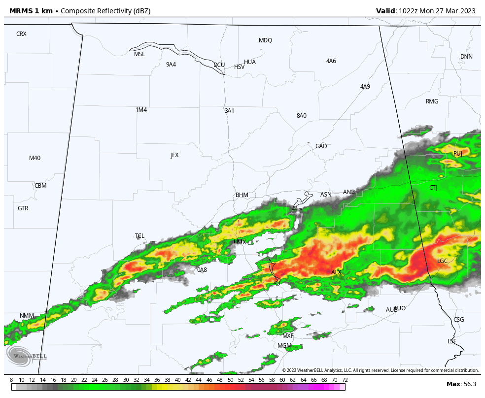
RADAR CHECK: A persistent band of rain and storms is across central Alabama this morning. Flash flood warnings are in effect for parts of Bibb, Chilton, Coosa, Talladega, Tallapoosa, Clay, Randolph and Chambers counties, where radar suggests some places have seen more than 7 inches of rain over the past 36 hours. A flash flood watch remains in effect for the central counties of the state as well.
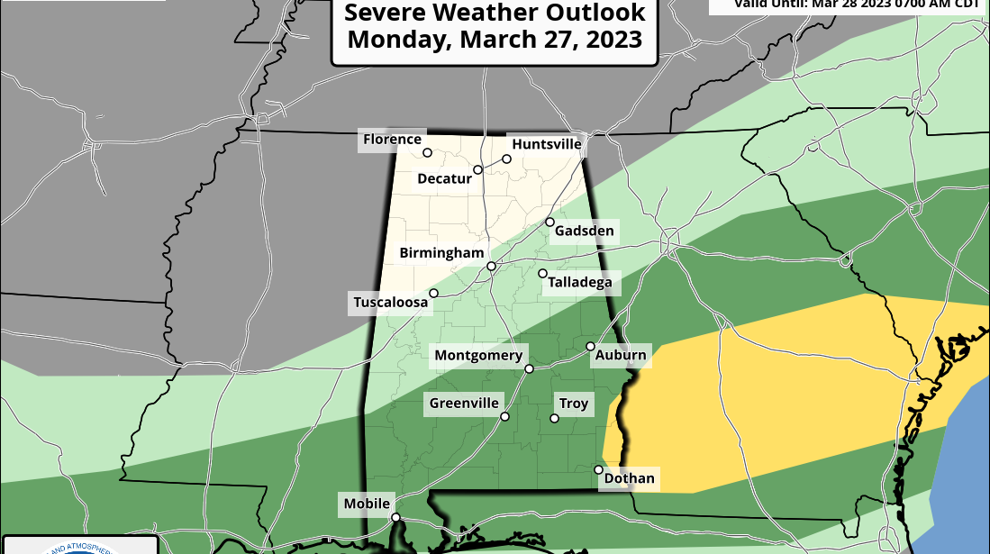
The rain will diminish across central Alabama later this morning, and by afternoon the main risk of showers and storms will shift into south Alabama, where the Storm Prediction Center (SPC) has defined a marginal risk (level 1 out of 5) of severe thunderstorms for this afternoon and evening. Heavier storms there could produce strong winds and small hail; we don’t expect any tornadoes as winds become unidirectional.
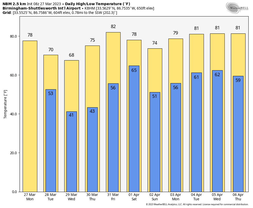
North Alabama will be dry today with some sun and a high in the low 70s.
TUESDAY: While north and central Alabama will be dry, showers and storms are possible across the southern quarter of the state. Again, the SPC has a marginal risk (level 1) in place there, where strong wind gusts and small hail could occur with the heavier thunderstorms. The risk Tuesday is south of a line from Grove Hill to Greenville to Troy to Eufaula.
WEDNESDAY/THURSDAY: Dry air will cover Alabama, and we get a chance to dry out with sunny, pleasant days and clear, cool nights. Highs will be in the 60s over north Alabama, with 70s across the southern counties. Colder spots across the northern half of the state could see lows in the mid to upper 30s, but freezing temperatures are not expected.
FRIDAY AND THE WEEKEND: Friday will be dry with a mix of sun and clouds; expect a high between 76 and 83 degrees. A significant severe-weather event is expected during the day Friday north and west of Alabama, and those showers and storms will move in here Friday night. For now, it looks like the main dynamic support will be shunted well north of here thanks to an upper ridge, and the overall severe-weather risk looks low. But you have to keep a close eye on any system like this in late March and early April.
Showers and storms Saturday morning over north Alabama will shift into the southern counties of the state by Saturday afternoon; the day will be warm with a high in the low 80s in most spots. Dry air settles into the state Sunday; with a mostly sunny sky, highs will be in the 60s and 70s.
NEXT WEEK: Moisture begins to return Monday, and the week looks unsettled with potential for multiple rounds for rain and storms. It’s way too early to know whether severe weather will be an issue.
ON THIS DATE IN 1994: An F4 tornado killed 20 people in the Goshen United Methodist Church during their Palm Sunday worship service. A total of 92 were injured. A warning was issued 12 minutes before the tornado destroyed the church building, but unfortunately they never heard the warning.
The deaths at the church brought to light the deficiencies in the NOAA Weather Radio network across the United States at the time, and the lack of NOAA Weather Radio use in many public spaces. We have come a long way since then, but we have much work to do. Every home, business, church and public place must have a way of hearing warnings.
BEACH FORECAST: Click here to see the AlabamaWx Beach Forecast Center page.
For more weather news and information from James Spann and his team, visit AlabamaWx.


