James Spann: Severe storms possible late Friday night across Alabama
SEVERE CLEAR: With a sunny sky, temperatures are mostly in the 70s across Alabama this afternoon. Tonight will be fair with a low in the 50s.
The day Friday will be dry, but clouds will increase with a gusty south wind developing by afternoon ahead of the next storm system. The high will be between 75 and 80 degrees.
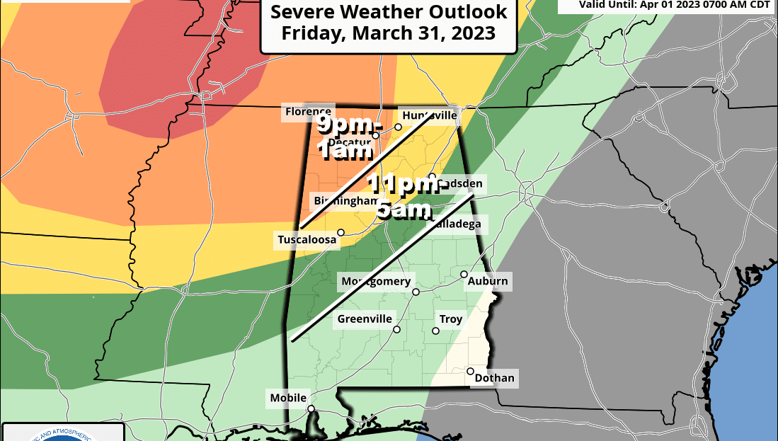
FRIDAY NIGHT: A line of showers and storms will pass through the state, and the storms could be severe. The Storm Prediction Center (SPC) has expanded the enhanced risk (level 3 of 5) to include areas west and north of a line from Madison to Jasper to Reform. A slight risk (level 2) is defined as far south as Gadsden, Hoover and Moundville. A marginal risk is defined down to places like Talladega, Clanton and Thomasville.A line of thunderstorms will enter northwest Alabama Friday in the 9 p.m.-midnight time frame, then progress southeastward in the hours before dawn Saturday. The primary threat will come from strong, potentially damaging winds, but an isolated tornado can’t be ruled out, especially in the enhanced risk area. In fact, the SPC is now suggesting there could be a strong tornado (EF-2 or higher) across northwest Alabama.
As always, it is very important to be able to hear warnings in the middle of the night as they are issued; the baseline is a NOAA Weather Radio. Be sure “Do Not Disturb” and “Sleep Mode” are disabled on your phone so you won’t miss any notifications.
Gradient winds will average 15-25 mph, with gusts to 30-35 mph possible in spots across north Alabama.
The weakening line of storms will shift into south Alabama Saturday morning and should be out of the state by early afternoon. Severe storms are not expected across south Alabama Saturday. For north and central Alabama, Saturday will be dry after the lingering early-morning showers with a partly sunny sky and a high between 75 and 80 degrees.
Sunday will be nice; with a sunny sky the high will be in the low to mid 70s.
NEXT WEEK: Moist air returns Monday along with a chance of showers and thunderstorms. The weather stays unsettled, with some risk of showers and storms daily through Thursday; it’s too early to know whether severe storms will become an issue. The latest global models suggest a stalled surface front could keep some risk of rain in the forecast Friday. Highs reach the mid 80s by Tuesday and Wednesday.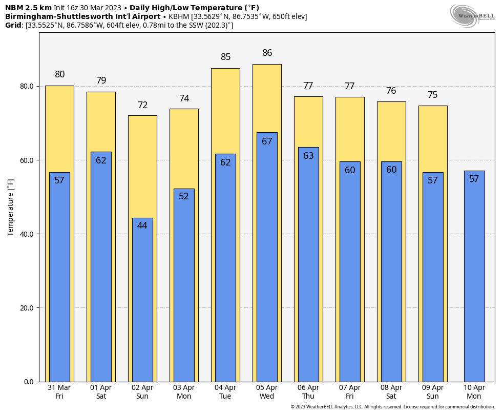 ON THIS DATE IN 1805: New York’s City’s Battery Park was strewn with 24-inch snow rollers from a ferocious storm between March 26 and March 28. Snow rollers are natural snowballs that are formed when winds blow over a snow-covered surface.
ON THIS DATE IN 2022: Sixteen tornadoes touched down across Alabama. The strongest was an EF3 that moved from Perry County into the southwest corner of Shelby County, close to Montevallo. Two people were injured; tens of thousands of hardwood and softwood trees were snapped and uprooted along the tornado’s path during max intensity.
BEACH FORECAST: Click here to see the AlabamaWx Beach Forecast Center page.
For more weather news and information from James Spann and his team, visit AlabamaWx.


