James Spann: Hot afternoons, generally dry for Alabama through the weekend

James Spann forecasts more quiet, hot, dry weather for Alabama from Alabama News Center on Vimeo.
DOG DAYS: An upper ridge will build across the Deep South this week, setting the stage for a hot and mostly dry forecast through the weekend. It is a simple forecast — mostly sunny days and fair nights with highs in the 90s and lows in the 70s. A few isolated afternoon storms could show up by Friday and the weekend, but the chance of any one spot getting wet is only 5-10% each day.
Not much change is expected for the first half of next week; there is some evidence the ridge weakens a bit in seven to 10 days with the return of scattered showers and thunderstorms by then. Highs will stay in the 90s.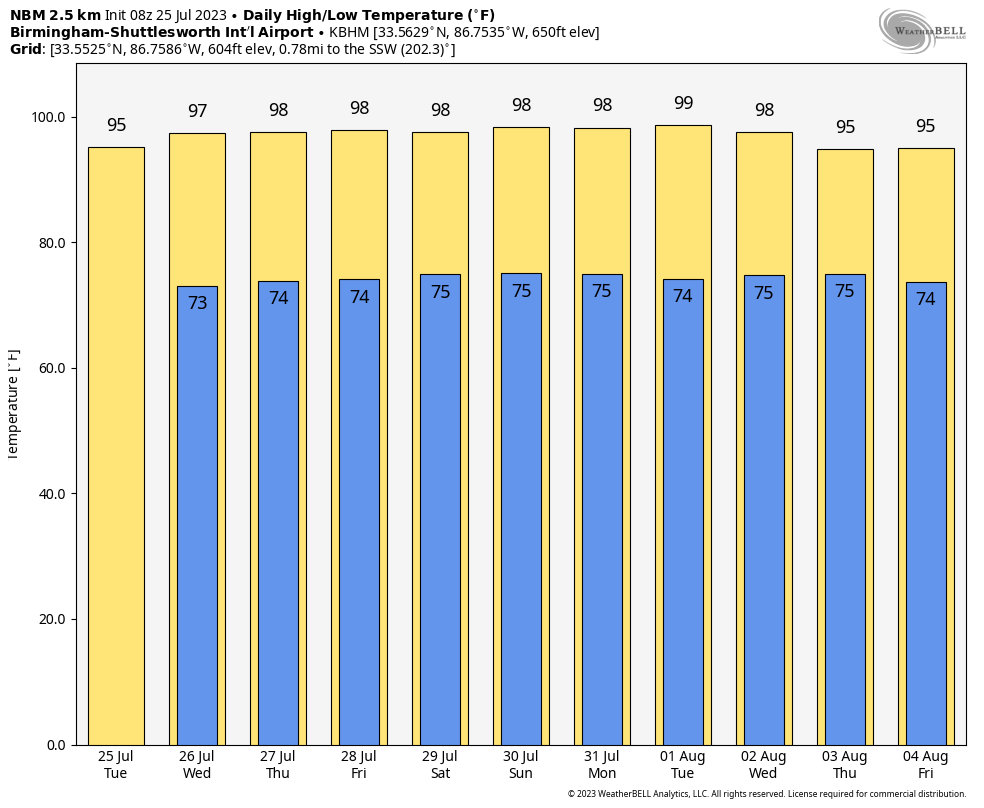 TROPICS: A tropical wave (Invest 95L) just east of the Windward Islands is producing a large area of disorganized showers and thunderstorms while moving quickly westward. Development, if any, of this system should be slow to occur during the next day or two before it moves into a region of unfavorable upper-level winds. Even though development is unlikely, locally heavy rains and strong, gusty winds are expected across portions of the Lesser Antilles during the next day or so. The chance of development is only 10%.
Also, a weak trough of low pressure is a few hundred miles south-southwest of Bermuda. Some gradual development of this system is possible while it moves west-northwestward toward the southeastern U.S. coast later this week and into the weekend. The National Hurricane Center gives this only a 20% chance of development over the next seven days. The rest of the Atlantic basin is quiet, and there are no tropical systems near the Gulf of Mexico.
RAIN UPDATE: Here are rain totals for the year so far, and the departure from average:
- Mobile — 37.63 inches (1.59 inches below average)
- Tuscaloosa — 36.51 (4.69 above average)
- Anniston — 34.91 (2.8 above average)
- Montgomery — 32.36 (1.65 above average)
- Birmingham — 32.24 (2.43 below average)
- Dothan — 31.82 (0.15 above average)
- Huntsville — 29.68 (3.03 below average)
- Muscle Shoals — 28.98 (3.89 below average)
ON THIS DATE IN 1936: Lincoln, Nebraska, saw an all-time high temperature of 115 degrees. The low only dropped to 91 degrees and the average temperature was 103. Many people spent the night sleeping outside to escape the heat.
ON THIS DATE IN 2005: The residents of Sand Point, Alaska, saw a rare tornado touchdown on two uninhabited islands. Sand Point is part of the Aleutian Chain and is about 570 miles southwest of Anchorage.
ON THIS DATE IN 2020: Hurricane Hanna, the 2020 Atlantic season’s first hurricane, made landfall in south Texas along the unpopulated Padre Island National Seashore, carrying sustained 90 mph winds with gusts over 100 mph in a small portion of the inner eye wall.
For more weather news and information from James Spann and his team, visit AlabamaWx.


