Scott Martin: Some showers, storms for Alabama today; not bad for Sunday, Labor Day
THE LABOR DAY WEEKEND: With high pressure beginning to move in from the northeast, drier air will begin to flow into Alabama today. Much of the northeastern part of the state will remain dry, but a stray shower or two might pop up. Much of the activity will be over the southwest part of the state, where scattered showers and storms will be possible. Afternoon highs will range from the upper 70s to the mid 80s.
Sunday will be dry across much of Alabama, except for locations right along the Alabama/Mississippi state line, where a few isolated to scattered afternoon showers and storms will be possible. Highs will be up in the mid to upper 80s.
Labor Day will be just a touch warmer, but we’ll keep nearly the same forecast as on Sunday. Much of the state will be dry, with a small chance of an isolated shower or two over the extreme western counties. Highs will be in the mid 80s to the lower 90s.
REST OF NEXT WEEK: Tuesday will be a not-so-bad late summer day with dry air and high pressure in place. No rain is expected, and highs will be in the upper 80s to the lower 90s.
Heat levels will rise on Wednesday as we remain dry with plenty of sunshine. Highs will be in the lower to mid 90s. The good news is that the heat index looks to stay close to the actual temperature.
Thursday and Friday will feature plenty of sunshine, but there may be enough moisture in the atmosphere for a small chance of an isolated afternoon shower. Don’t expect much precipitation, as dewpoints will remain lower. Highs will be in the lower to mid 90s.
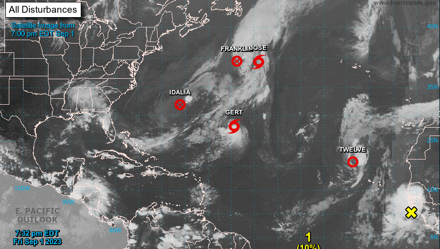
TROPICS: We have three active tropical systems and one area of interest in the Atlantic Ocean. Franklin and Idalia have become remnant lows after both hitting major hurricane strength earlier this week. Tropical Storm Jose will not last long and will be absorbed by the remnants of Franklin. Tropical Storm Gert may strengthen a little on Saturday, but she will eventually dissipate by Monday evening. Tropical Depression 12 may become a brief-lived tropical storm on Saturday but is expected to degenerate into a remnant low Sunday evening. Lastly, a tropical wave is forecast to move over the eastern Atlantic Ocean during the next 24 hours and has a medium chance of becoming a depression around midweek. For now, there is no threat to the United States from any tropical systems.
For more weather news and information from James Spann, Scott Martin and other members of the James Spann team, visit AlabamaWx.


