James Spann: Quiet weather pattern continues for Alabama through the weekend
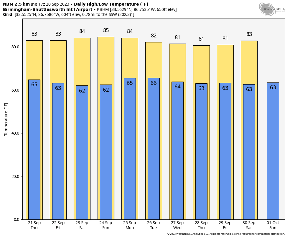
WARM AFTERNOON: Temperatures are generally in the low to mid 80s across Alabama this afternoon with a mix of sun and clouds. We note a few showers and storms along the Gulf Coast, but the rest of the state is dry. The average high for Birmingham on Sept. 20 is 85. Tonight will be mostly fair with a low in the 60s.
Alabama’s weather won’t change over the next few days; we expect mostly to partly sunny, warm days and fair, pleasant nights through the weekend with highs in the 80s and lows generally in the 60s. We will, however, mention the risk of a few isolated showers over southeast Alabama Thursday and over northwest Alabama Sunday ahead of a surface front. But even in those places, the odds of any specific place seeing rain will be 20% or less.
NEXT WEEK: Moisture levels rise, and a few scattered showers are possible statewide Monday through Wednesday — nothing too heavy or widespread, and we trend drier toward the latter half of the week. Highs will remain in the 80s.
 FOOTBALL WEATHER: The sky will be clear for the high school games across Alabama Friday night, with temperatures falling through the 70s, possibly reaching the 60s by the fourth quarter.
Saturday Auburn will travel to College Station to take on Texas A&M (11 a.m. CT kickoff). The sky will be mostly sunny with temperatures rising from near 88 at kickoff to near 93 by the final whistle.
Alabama will host Ole Miss at Bryant-Denny Stadium Saturday (2:30 p.m. kickoff). The sky will be mostly sunny with temperatures in the mid 80s.
UAB will be in Athens to take on Georgia Saturday (6:30 p.m. CT kickoff). The weather looks dry with a mostly clear sky; temperatures will fall from near 77 at kickoff into the 60s by the fourth quarter.
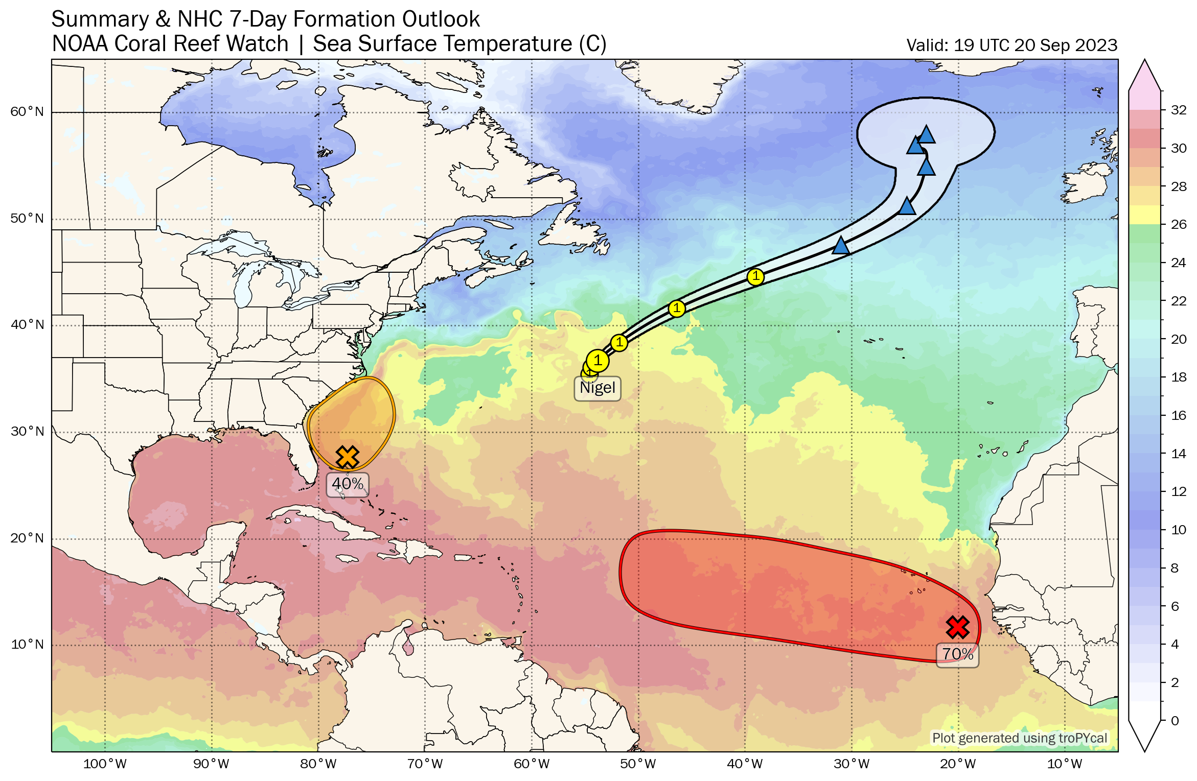
TROPICS: Hurricane Nigel continues to spin away in the middle of the Atlantic with winds of 90 mph. It becomes post-tropical Friday as it moves into the cooler water of the North Atlantic, remaining far from land.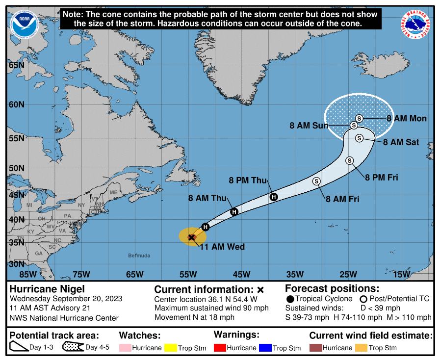
Closer to home, a nontropical low-pressure system is expected to form within a large area of disorganized showers and thunderstorms east of the Florida peninsula within the next day or two. This system could acquire some subtropical characteristics on Friday while it moves generally northward. Regardless of development, this low is likely to bring gusty winds to gale force, heavy rain and high surf to portions of the Southeast and Mid-Atlantic United States late this week and into this weekend.
A tropical wave is a couple of hundred miles southeast of the Cabo Verde Islands. This system is expected to merge with another disturbance a few hundred miles to its west in a few days. Environmental conditions are forecast to be conducive for gradual development. A tropical depression is likely to form late this week or this weekend while the system moves generally westward at 10 to 15 mph across the eastern and central tropical Atlantic. It’s too early to know whether this recurves into the open Atlantic or makes a run for the Lesser Antilles. The National Hurricane Center gives it a 70% chance of development.
No tropical systems are expected near the Gulf of Mexico for at least the next seven days.
ON THIS DATE IN 1909: A large, deadly Category 3 hurricane made landfall near Grand Isle, Louisiana, during the late evening. The states of Louisiana and Mississippi showed catastrophic damage resulting in 371 deaths.
ON THIS DATE IN 1967: Hurricane Beulah made landfall near Brownsville as a powerful Category 3 hurricane. It spawned 115 tornadoes across Texas, which established a new record for the highest number of tornadoes produced by a tropical cyclone. Due to its slow movement over Texas, Beulah led to significant flooding.
ON THIS DATE IN 2017: Hurricane Maria made landfall in Puerto Rico as a Category 4 storm. The storm left the entire island without power and was responsible for nearly 3,000 deaths.
For more weather news and information from James Spann and his team, visit AlabamaWx.


