James Spann: Patchy drizzle for Alabama this evening; cooler air arrives Sunday

CLOUDY OCTOBER AFTERNOON: Clouds cover most of Alabama this afternoon with temperatures in the upper 60s and low 70s. Some patchy drizzle is over east Alabama; that will end tonight as drier air moves into the state.
THE ALABAMA WEEKEND: Saturday will be mostly sunny and mild, with a high in the 70s. Sunday will be breezy and much cooler, with a high in the 50s over the Tennessee Valley and low to mid 60s elsewhere. The sky will be occasionally cloudy, and a few sprinkles can’t be ruled out. Temperatures drop into the 40s by Monday morning.
NEXT WEEK: For now, the week continues to look cool and dry, with highs in the 60s Monday and Tuesday, followed by low to mid 70s over the latter half of the week. We are seeing evidence rain returns to the Deep South at some point over the following weekend, Oct. 21-22.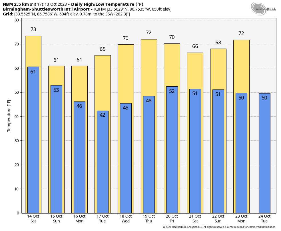
FOOTBALL WEATHER: For the high school games tonight, the sky will be mostly cloudy with just a small risk of a shower or some drizzle. Temperatures will fall from near 70 at kickoff to the mid 60s by the final whistle.
Saturday, Alabama hosts Arkansas at Bryant-Denny Stadium (11 a.m. kickoff). The sky will be mostly sunny with temperatures rising from near 72 at kickoff into the mid 70s by the fourth quarter.
Auburn will be in Baton Rouge to take on LSU (6 p.m. kickoff). The sky will be clear with temperatures falling from near 78 at kickoff into the upper 60s by the final whistle.
UAB is also on the road, taking on UTSA in San Antonio (7 p.m. CT kickoff). The Roadrunners play their home games at the Alamodome, so weather won’t be an issue. But for the fans headed that way, Saturday in San Antonio will be sunny with a high in the mid 80s. It will be clear Saturday night with temperatures falling through the 70s after sunset.
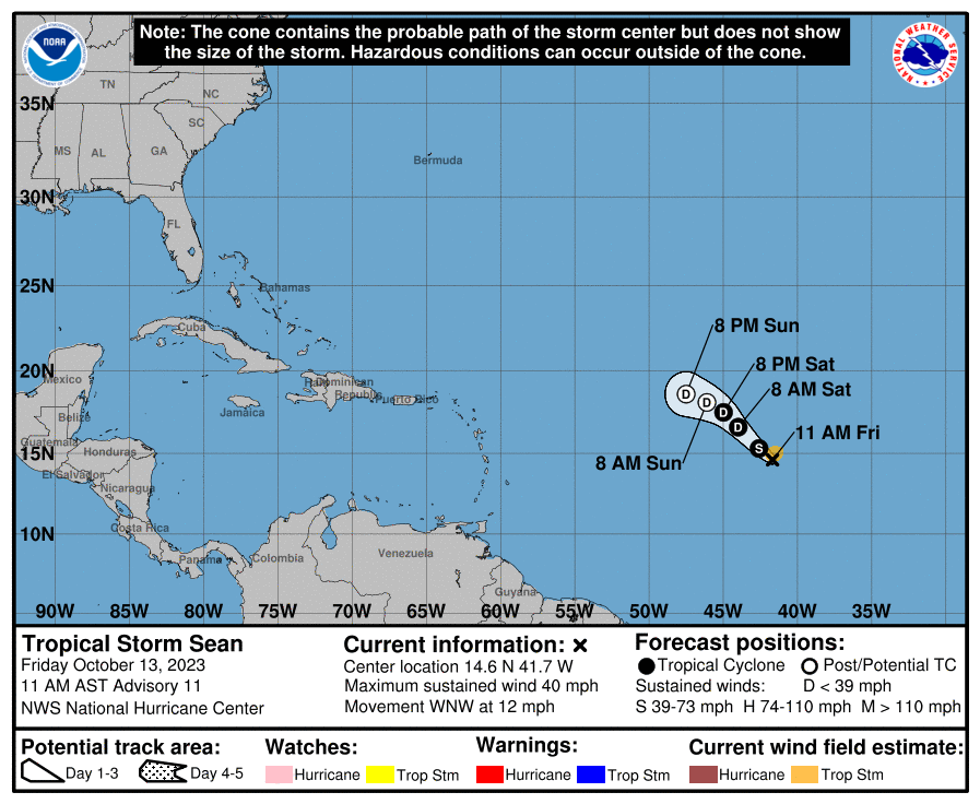
TROPICS: Tropical Storm Sean, with winds of 40 mph, is a weak, sheared system in the middle of the Atlantic between the Lesser Antilles and Africa. It is expected to dissipate far from land by Sunday night.
 A broad area of low pressure several hundred miles south-southwest of the Cabo Verde Islands continues to produce disorganized showers and thunderstorms. Environmental conditions are expected to become more conducive for development by the end of the weekend while the disturbance begins to move westward across the central tropical Atlantic. Additional development is expected after that, and a tropical depression is likely to form during the early to middle portion of next week as the system moves steadily westward across the central and western tropical Atlantic.
The National Hurricane Center gives the system an 80% chance of development over the next seven days.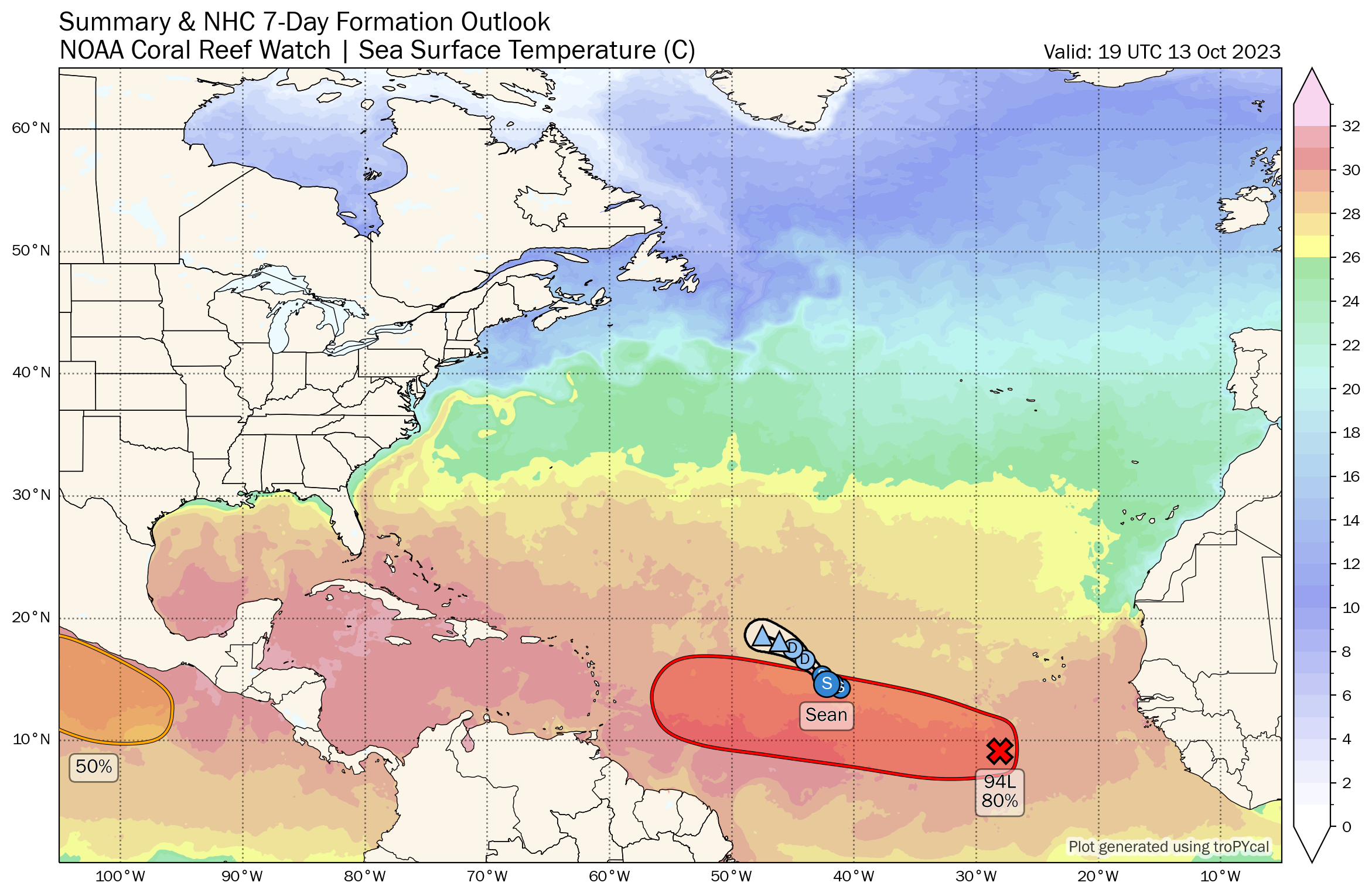 SOLAR ECLIPSE SATURDAY: The annular solar eclipse (the path runs from parts of south Texas to Oregon) will be visible in Alabama as a partial eclipse. For Birmingham (and most of Alabama), it begins at 10:38 a.m., peaks at 12:08 p.m. and ends at 1:43 p.m. At the peak, 57.5% of the sun will be obscured by the moon. For now, it looks like the sky will be mostly clear during the event here. Be sure and use eclipse glasses from a reputable dealer. Never watch a solar eclipse with the naked eye or sunglasses.
ON THIS DATE IN 2006: The October 2006 Buffalo storm was an unusual early-season lake-effect snowstorm that hit the Buffalo, New York, area and other surrounding areas of the United States and Canada. Downtown Buffalo reported 15 inches from this event.
For more weather news and information from James Spann and his team, visit AlabamaWx.


