Scott Martin: Cloudy, cool in Alabama, with showers likely today

MORE RAIN: We have plenty of light to moderate rain across a good portion of central Alabama early this morning, while the Tennessee Valley is mainly dry, with only a few light, scattered showers. We’ll keep high rain chances through the day. Much of the activity will be along and south of the I-20 corridor, but scattered showers will be possible north of that. It will be cool, with highs only in the mid to upper 50s.
We’ll keep rain chances in the forecast for Thursday, mostly over the southern half of the state, while a few showers will be possible for the northern half. Rain chances will be a bit higher for central Alabama on Friday, but not an all-day washout. Highs on both days will be in the mid to upper 60s for the most part, with a few lower 70s on Friday.
THE WEEKEND AND BEYOND: Much of the weekend will be dry with mostly sunny skies and highs in the 60s both days. However, rain chances will move back into the state Sunday evening, and showers become likely on Monday and continue on Tuesday. While it’s a cold November rain that most don’t like, it is helping out with our drought situation. Highs will be in the upper 50s to the upper 60s both days. The good news is that rain will be out of here in time for Thanksgiving, Black Friday and that big rivalry game that everyone around here talks about 365 days a year.
TROPICS: Apparently, the tropics have realized that the end of hurricane season is close upon us and are trying to step up their game before time runs out.
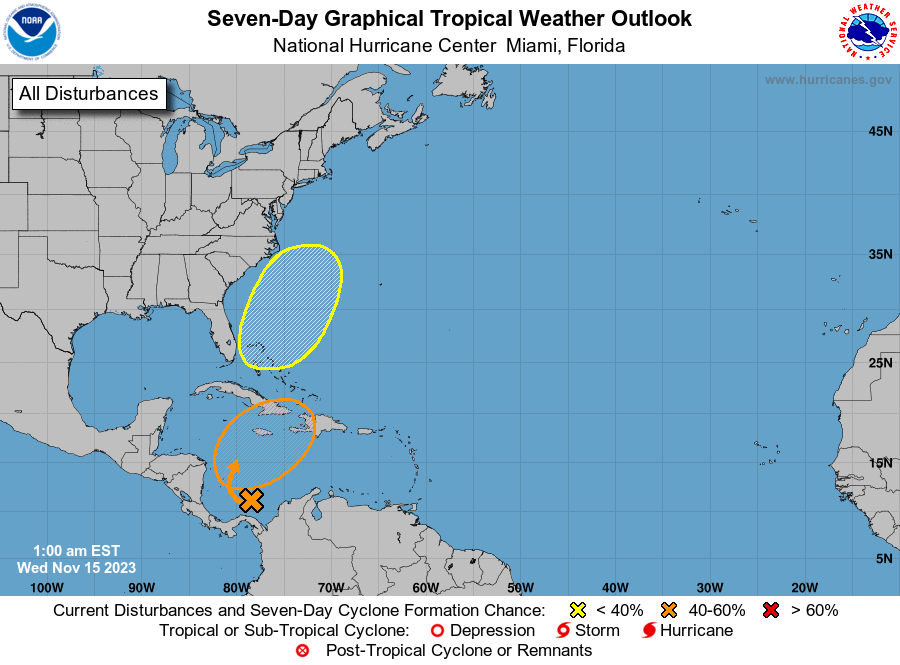
A large area of disorganized showers and thunderstorms over the southwestern Caribbean Sea is associated with a broad trough of low pressure. Environmental conditions appear marginally conducive for development of this system, and a tropical depression could form late this week while the system begins moving northeastward across the western and central Caribbean Sea. Interests in Jamaica, Cuba, Haiti, the Dominican Republic, the southeastern Bahamas, and the Turks and Caicos Islands should monitor the progress of this system. Regardless of development, it has the potential to produce heavy rains over portions of the Caribbean coast of Central America and the Greater Antilles through the end of this week. The formation chance through seven days is 50%.
An area of low pressure is expected to develop near southern Florida in a day or so. This system is then forecast to move northeastward near the Bahamas and offshore of the U.S. East Coast late this week and over the weekend. Although development into a tropical cyclone appears unlikely, this system is expected to produce gusty winds and heavy rains across portions of southern Florida, the Florida Keys and the Bahamas during the next couple of days. The formation chance through seven days is 10%.
For more weather news and information from James Spann, Scott Martin and other members of the James Spann team, visit AlabamaWx.


