James Spann: Alabama stays dry through Friday; rain returns Sunday
James Spann has the midweek forecast for Alabama from Alabama News Center on Vimeo.
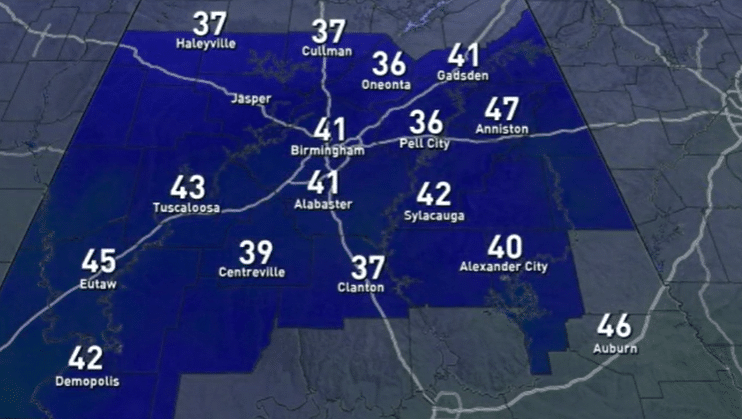
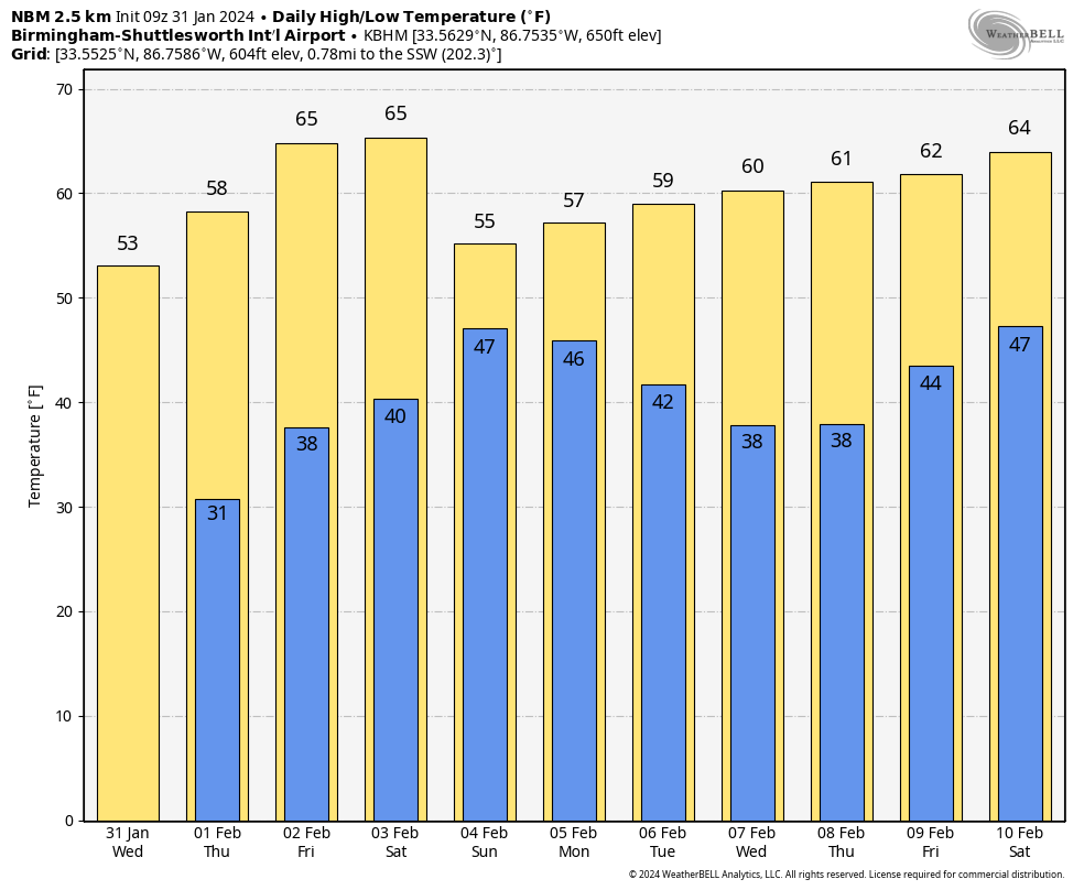
COOLER: The clipper that brought some light rain to Alabama last night has moved on to the east, and today will be mostly sunny and cooler, with highs in the 50s. Dry weather continues through Friday with sunny days and fair nights; highs will be between 55 and 65 degrees Thursday and in the 60s statewide Friday. Some south Alabama communities could reach the low 70s Friday afternoon.
THE ALABAMA WEEKEND: Saturday will be dry and pleasant, with highs between 63 and 73 across Alabama. Clouds will increase late in the day, and rain will likely enter the western counties after midnight Saturday night. Periods of rain are likely Sunday; some thunder is possible over south Alabama, but at this point severe storms are not expected. Highs will be generally in the 50s.
NEXT WEEK: We will mention a chance of some lingering light rain Monday as an upper low moves through; then we expect dry weather Tuesday through Thursday with highs in the 50s and 60s. Some light rain could arrive on Friday, Feb. 9. There’s still no sign of bitterly cold arctic air for the Deep South for the next seven to 10 days.
 ON THIS DATE IN 1951: The costliest ice storm on record devastated an area of more than 100 miles wide from Louisiana to West Virginia. This ice storm swept through north Mississippi, northwest Alabama, west and middle Tennessee, most of Kentucky and parts of southern Ohio. High winds from a line of thunderstorms that developed from southwestern Louisiana to central Mississippi and northern Alabama combined with the ice glaze to result in widespread tree and power-line damage.
ON THIS DATE IN 1989: The barometric pressure at Norway, Alaska, reached 31.85 inches (1,078.4 millibars), establishing an all-time record for the North American continent. The temperature at the time of the record was about 46 degrees below zero. The severe arctic cold began to invade the north-central U.S. The temperature at Grand Fall, Montana, plunged 85 degrees in 36 hours. Valentine, Nebraska, plummeted from a record high of 70 degrees to zero in just nine hours. Northwest winds gusted to 86 mph at Lander, Wyoming, and wind chill readings of 80 degrees below zero were reported in Montana.
For more weather news and information from James Spann and his team, visit AlabamaWx.


