James Spann: Frost possible in Alabama tonight; rain returns Friday
SUNNY, COOL AFTERNOON: Despite sunshine in full supply, temperatures are only in the 50s across Alabama this afternoon. The average high for Birmingham on March 19 is 68.
Tonight will be clear and not as cold as last night, but some of the colder pockets across north and central Alabama could very well see another freeze by daybreak. A frost advisory has been issued for the northern two-thirds of the state. A warming trend begins Wednesday afternoon, with a high in the low 70s for most places.
THURSDAY/FRIDAY: The day Thursday will be dry, but clouds will increase, and rain returns to Alabama after midnight as a surface low passes near the Gulf Coast. There could be some thunder, but there is no risk of severe storms, and rain amounts will be one-half to 1 inch. Friday’s high will be in the low 60s.
THE ALABAMA WEEKEND: Rain will move out of the state Friday night, and the weekend will be dry. The sky becomes sunny Saturday with a high in the 60s. Sunday will be another sunny day with a high between 70 and 75 degrees. Mornings will be cool, with lows in the 40s. Colder pockets will dip into the mid to upper 30s early Sunday morning with some scattered frost possible.
NEXT WEEK: Monday will be dry with a high in the low to mid 70s; rain returns to the state Tuesday. A few thunderstorms could be involved; the latest global model data suggests little to no risk of severe storms. Rain should end Wednesday morning, and Thursday and Friday look dry with highs in the low 70s.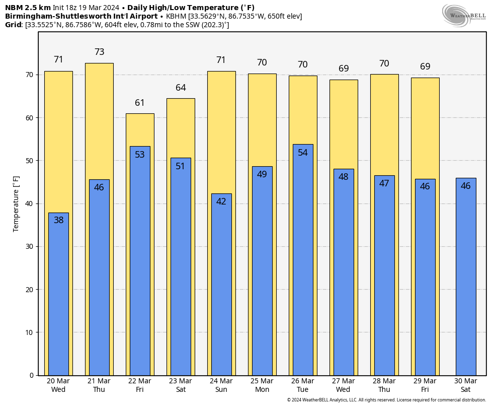
SPRING BEGINS: Today is the first day of spring; the equinox comes tonight at 10:06. At the equinox, Earth’s two hemispheres are receiving the sun’s rays equally. Night and day are approximately equal in length.
ON THIS DATE IN 1948: An estimated F4 tornado moved through Fosterburg, Bunker Hill and Gillespie, Illinois, killing 33 people and injuring 449 others. Two thousand buildings in Bunker Hill were damaged or destroyed.
ON THIS DATE IN 2018: An EF3 tornado tore through Jacksonville in Calhoun County. It first touched down west of U.S. 431 north of Wellington, where it rapidly intensified and widened. The tornado entered Jacksonville, where it gained strength into the EF3 category, with winds around 140 mph. It removed most of the roof and the top floor of two buildings in an apartment complex. The tornado affected most of the campus of Jacksonville State University. Several buildings sustained significant damage. The most intense winds remained north of the campus, however, mowing down trees and causing direct damage to homes.
The tornado caused major damage to the Merrill Building. It then moved into a highly populated zone, where scores of homes sustained major damage, rendering many uninhabitable. The tornado maintained its strength as it crossed Choccolocco Mountain, with winds funneled up the valleys, mowing down trees. Despite the damage, there were no fatalities and only one serious injury.
The same day, very large and destructive hail in Cullman was responsible for major damage to vehicles, homes and businesses. An Alabama record 5.38-inch-diameter hailstone was confirmed by the National Weather Service.
For more weather news and information from James Spann and his team, visit AlabamaWx.


