James Spann: Higher rain chances, lower heat levels for Alabama today
James Spann says heat levels down, rain chances up for Alabama today from Alabama News Center on Vimeo.
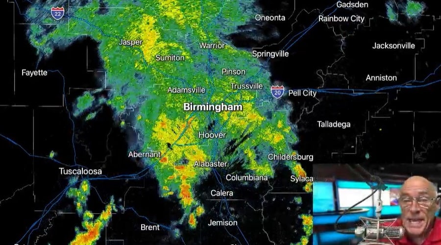
RADAR CHECK: Areas of rain and a few thunderstorms are moving across Alabama early this morning as the upper ridge has weakened over the region. Rain chances are higher today and heat levels will be lower, with many places across Alabama staying below 90 degrees through the afternoon. We still can’t promise rain for everyone, but the chance of any one place getting wet today is 50-70%.
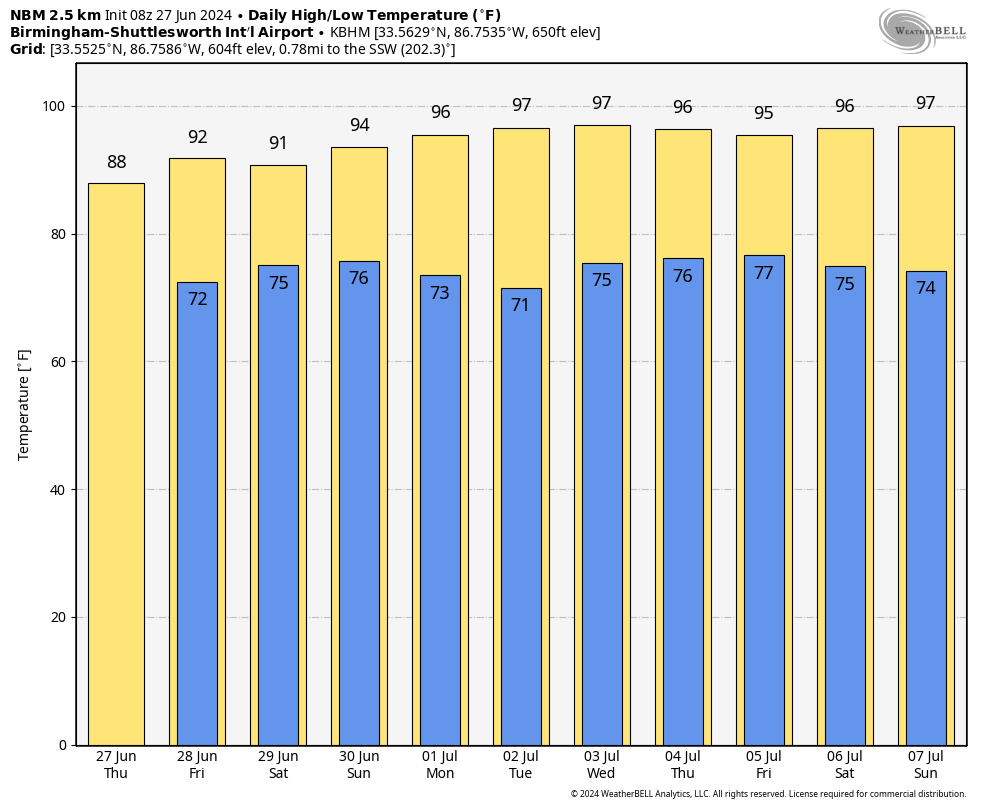
On Friday, we expect a mix of sun and clouds with scattered showers and thunderstorms, especially during the afternoon and evening. The high will be in the low 90s for most communities, right at average levels for late June.
THE ALABAMA WEEKEND: We’re looking at pretty routine summer weather for the weekend, partly sunny days with scattered, mostly afternoon and evening showers and thunderstorms. The chance of any specific location seeing rain both days is 50-60%, and most (but not necessarily all) of the showers will come from about 1 until 10 p.m. The high will be in the low 90s Saturday, followed by mid 90s Sunday.
NEXT WEEK: Drier air moves into the state for the first half of the week; we expect mostly sunny, hot days and fair nights Monday through Wednesday with only a small risk of a shower each day. Highs will rise into the mid to upper 90s. A pop-up afternoon storm is a bit more likely by Thursday and Friday, but, even then, widespread rain isn’t especially likely.
TROPICS: A tropical wave over the west-central Caribbean Sea is producing widespread but disorganized shower and thunderstorm activity while it moves rapidly westward at around 25 mph. Environmental conditions could become more conducive for some gradual development later this week over the western Caribbean Sea or over the southwestern Gulf of Mexico during the weekend. The National Hurricane Center (NHC) gives it only a 20% chance of development for now; if anything happens to form, it will move into Mexico.
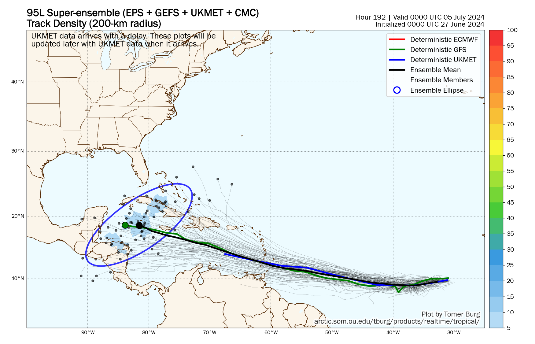
Of more interest is a tropical wave several hundred miles southwest of the Cabo Verde Islands that continues to produce disorganized shower and thunderstorm activity. Environmental conditions are forecast to be unusually conducive for late June across the central and western tropical Atlantic, and further development of this system is anticipated. A tropical depression or tropical storm is likely to form this weekend several hundred miles east of the Windward Islands while the system moves westward at 15 to 20 mph. The NHC gives it a 70% chance of development.
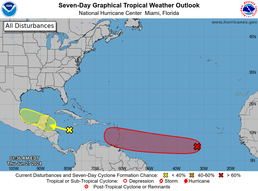
It’s way too early to know the ultimate destination of this system; it all depends on how the upper air pattern evolves in seven to 10 days. The model spread is anywhere from Central America to the Bahamas; we will have much better clarity early next week. There will be no tropical storms or hurricanes for the central Gulf Coast (Gulf Shores to Panama City Beach) through next week.
ON THIS DATE IN 1957: Hurricane Audrey made landfall at Sabine Pass and Johnson Bayou, Louisiana. Audrey ranks as the seventh-deadliest hurricane to strike the United States (third-deadliest within Louisiana) in modern record keeping, with at least 500 deaths. The exact number will never be known, as many perished in the storm surge in Cameron and Vermilion parishes, and many missing persons were never found.
Along with Hurricane Alex in 2010, it was the strongest June hurricane ever recorded in the Atlantic basin as measured by pressure. The rapidly developing storm struck southwestern Louisiana as an intense Category 3 hurricane, destroying coastal communities with a powerful storm surge that penetrated as far as 20 miles inland.
For more weather news and information from James Spann and his team, visit AlabamaWx.


