James Spann: Only isolated showers for Alabama today; rain more likely Thursday
MOSTLY DRY TODAY: Much of Alabama will be rain-free today; we expect only a few isolated showers over the southern third of the state this afternoon. Highs will range from the mid to upper 80s over the northern counties to the low 90s down south.
A disturbance will bring rain to the southern half of Alabama Thursday and the southern two-thirds Friday. Most of the rain Thursday will be along and south of I-20 (Tuscaloosa to Birmingham to Anniston), and Friday rain is most likely south of U.S. 278 (Hamilton to Cullman to Gadsden). Rain amounts from I-20 south will be 1-2 inches, but the Tennessee Valley will be shortchanged with only very light amounts.
Temperatures will continue to trend downward; expect highs in the 80s Thursday and only in the 70s Friday because of clouds, rain and a cool low-level easterly flow.
THE ALABAMA WEEKEND: A front has potential to bring a few isolated showers to Alabama Saturday, but most of the day will be dry with a mix of sun and clouds and a high in the 80s. A very dry air mass settles into the Deep South Sunday with a sunny sky; after starting the day in the 50s, the high will be in the mid 80s for most places.
NEXT WEEK: For now, much of the week looks dry with seasonal temperatures, highs in the 80s and lows in the 50s and 60s.
 TROPICS: The National Hurricane Center (NHC) continues to monitor two tropical waves in the central and eastern Atlantic basin; development is not expected with either system due to unfavorable environmental conditions.
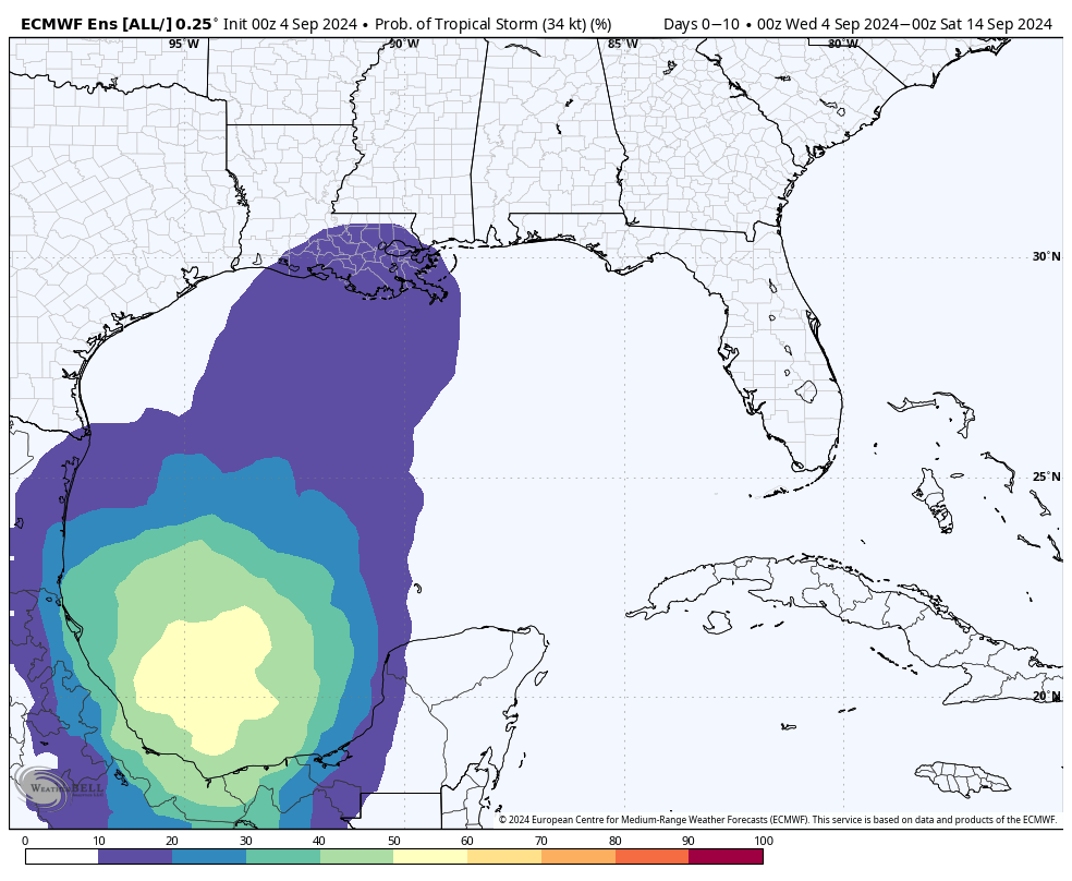
Also, a tropical wave moving quickly westward at about 20 mph is producing a large area of disorganized showers and thunderstorms over Hispaniola and portions of the central Caribbean Sea. Some development is possible late this week when the wave slows down over the northwestern Caribbean Sea or early next week over the southwestern Gulf of Mexico. The NHC gives the system a 30% chance of development over the next seven days.
Global models hint a depression or storm could form in the Bay of Campeche in four or five days, but then they don’t do much with it as the system tries to lift northward next week. It remains simply something to watch for now.
FOOTBALL WEATHER: For high school games across the state Friday night, some rain is possible, if not likely, over the southern two-thirds of the state. We’re not expecting much thunder, however, and temperatures will be in the 70s.
On Saturday, Auburn will host California at Jordan-Hare Stadium (2:30 p.m. kickoff). The sky will be partly sunny, and a brief shower can’t be ruled out. Temperatures will hover in the low to mid 80s during the game.
Alabama will host South Florida Saturday in Tuscaloosa (6 p.m. kickoff). The sky will be mostly clear with temperatures falling from the low 80s at kickoff into the upper 60s by the final whistle.
UAB will be on the road, taking on Louisiana-Monroe Saturday (6 p.m. kickoff). The sky will be clear with about 83 degrees at kickoff; temperatures drop to near 70 degrees by the fourth quarter.
ON THIS DATE IN 1941: A violent tornado ripped through northeast and north Minneapolis shortly after noon. The hardest-hit location was the Soo Line Railroad’s Shoreham Yards, where four people died and at least 50 were injured. The death toll at Soo Line could have been higher, but the tornado struck five minutes after the lunch bell went off, meaning 100 men had left the shops.
ON THIS DATE IN 2011: The center of Tropical Storm Lee moved ashore around sunrise. It would be a while before Lee would weaken to a depression as it remained nearly stationary while the southern half of the circulation was over water, where it could continue to derive additional energy from the warm ocean. Lee brought torrential rains to Louisiana, Mississippi and Alabama.
For more weather news and information from James Spann and his team, visit AlabamaWx.