James Spann: Big rain event for Alabama Wednesday, Thursday
UNSETTLED WEATHER AHEAD: We have a few spotty showers across Alabama early this morning; we will maintain the chance of scattered showers and a few storms through tonight. The Storm Prediction Center maintains a marginal risk (level 1 out of 5) of severe thunderstorms for the Tennessee Valley this afternoon and early tonight; heavier storms there could produce small hail and gusty winds. Otherwise, today will be partly sunny with a high at or just over 90 degrees.
The weather will be wet Wednesday with occasional rain ahead of a surface front, and rain continues Thursday ahead of the tropical system in the Gulf. Rain will likely be heavy at times late Thursday and Thursday night, then will diminish Friday morning. We expect just a few scattered showers Friday afternoon and night.
Over the weekend, a few scattered showers are possible; the highest coverage will likely be on Sunday. But, on both days, the rain won’t be widespread or heavy. Highs will be in the low 80s.
PTC 9: This morning Potential Tropical Cyclone 9 remains disorganized. The broad center is about 240 miles south-southeast of the western tip of Cuba, and winds are 35 mph. It is moving northwest at 8 mph.
There’s not much change to the National Hurricane Center forecast this morning; the system is expected to become a tropical storm late today or tonight and a hurricane Wednesday in the Gulf of Mexico. Landfall is forecast in the Florida Big Bend region southeast of Tallahassee Thursday evening as a major Category 3 hurricane with winds of 115 mph.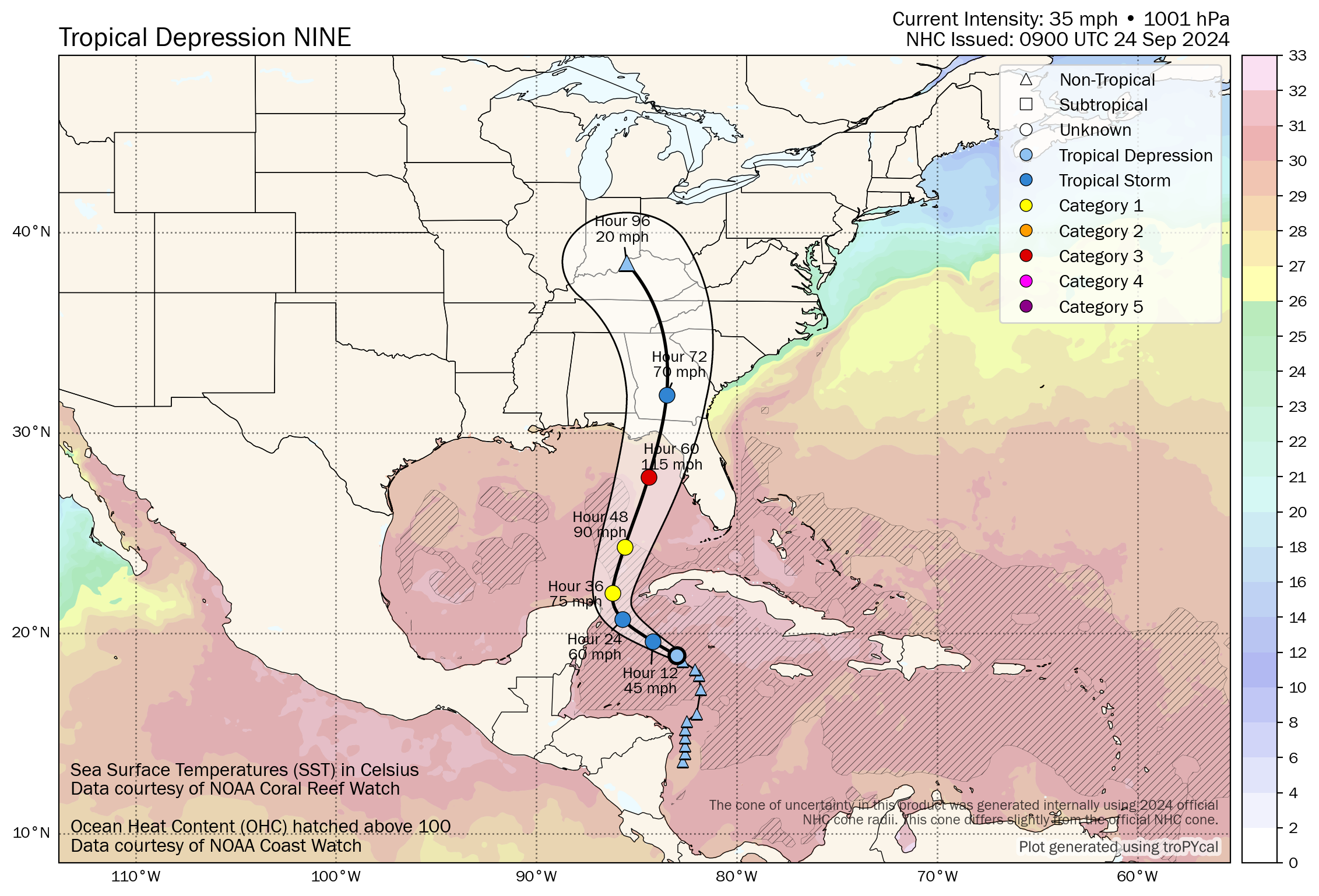 Key messages:
- A hurricane watch has been issued for the Gulf Coast of Florida from Englewood northward and westward to Indian Pass, including Tampa Bay.
- A tropical storm watch has been issued for the Gulf Coast of Florida from Indian Pass to the Walton/Bay County line and from north of Bonita Beach to south of Englewood.
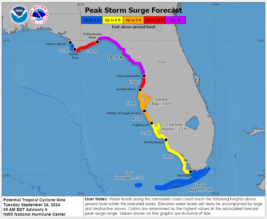
- The main impact in terms of wind, storm surge, flooding and isolated tornadoes will be from Carrabelle to Cedar Key and down to Tampa Bay (the east side of the circulation).
- The central Gulf Coast (Gulf Shores to Panama City Beach) is on the good, west side of the circulation with an offshore flow. There will certainly be some rain and wind for places like Panama City Beach, Mexico Beach, Port St. Joe and Cape San Blas, but the big issues with dangerous storm surge will be east of there. The Alabama Gulf Coast, Pensacola, Navarre Beach, Fort Walton Beach and Destin will have breezy, showery weather, but nothing dangerous based on the current forecast track.
- A 10- to 15-foot storm surge is forecast from the Ochlockonee River down to Chassahowitzka on the Florida coast. The storm surge around Tampa Bay is forecast to be 5-8 feet.
- The southeast corner of Alabama (around Dothan) could see wind gusts to 40-45 mph Thursday night. The rest of east Alabama will see gusts to 35 mph; gusts over the western half of the state will be 20-30 mph.
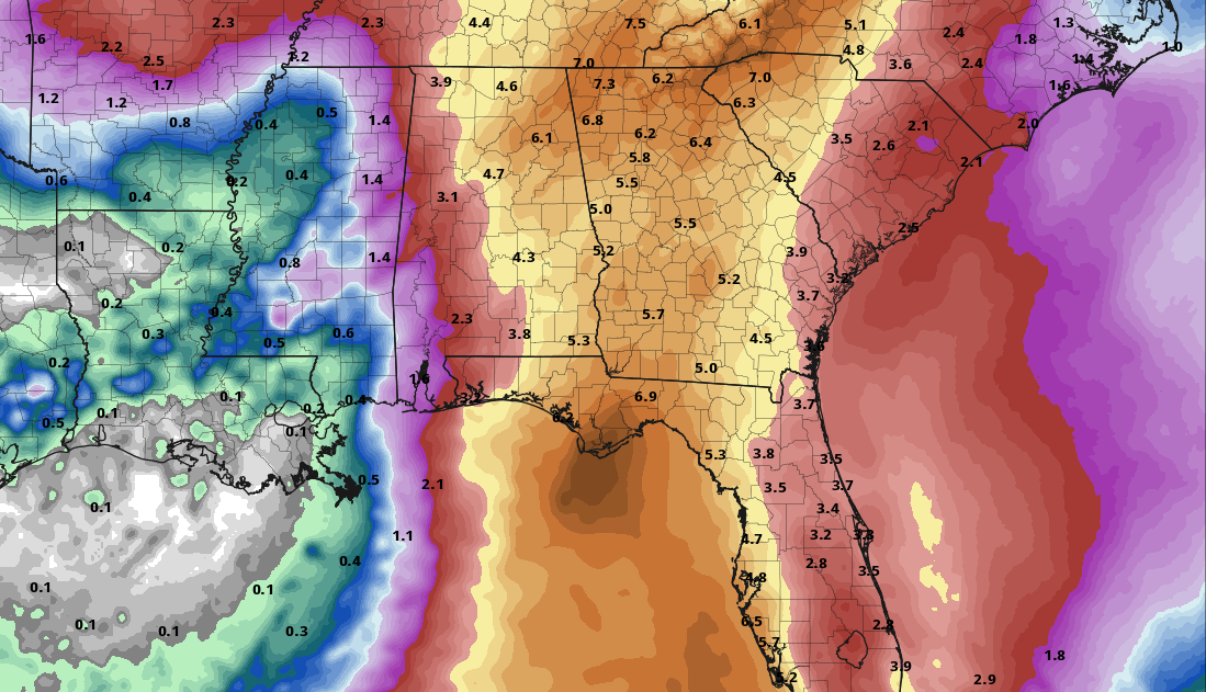
- The eastern half of Alabama has potential for 4-5 inches of rain Wednesday through Friday morning; rain potential for the western counties is 2-3 inches. A flash flood watch has been issued for southeast Alabama.
- Tornadoes are not expected in Alabama. Any isolated tornadoes will be along the east of the center of circulation as Helene moves northward east of Alabama.
- The weather will improve across Alabama by midday Friday; we expect just a few scattered, light showers Friday night and Saturday. The weather won’t be bad at all for high school and college games in the state, but a passing shower can’t be ruled out. Wind will be less than 10 mph.
Remember, any tropical forecast can change. Watch for updates.
ON THIS DATE IN 1956: Hurricane Flossy made landfall near Destin as a Category 1 storm.
For more weather news and information from James Spann and his team, visit AlabamaWx.


