James Spann: Falling temps today, cold weekend ahead for Alabama

RADAR CHECK: A line of showers and thunderstorms is pushing into south Alabama early this Thanksgiving morning ahead of a cold front. A tornado warning was issued for eastern Elmore County around 5:30, but the rotation broadened quickly, and the warning was canceled soon after it was issued. Otherwise, the storms were well behaved overnight, remaining below severe limits. There is a marginal risk (level 1 out of 5) for south Alabama this morning, but the overall threat remains very low.
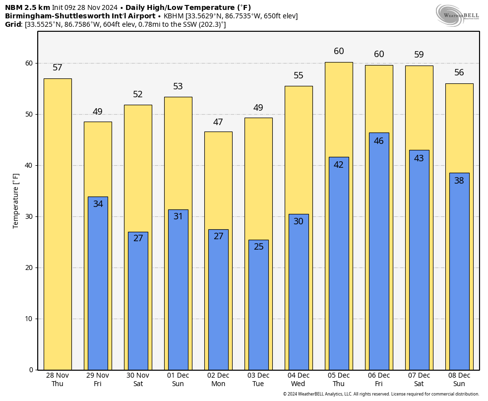
Behind the front, temperatures will fall through the day, reaching the 40s over the northern counties by afternoon with a brisk north wind. Slow clearing will begin this afternoon, and tonight will be fair and cold, with a low in the 30s.
FRIDAY AND THE WEEKEND: The weather will be cold and dry. Lows early Saturday and Sunday mornings will be between 25 and 32 degrees for the northern two-thirds of Alabama, with mid 30s to the Gulf Coast. Highs will be between 47 and 54 degrees for north Alabama, with mid to upper 50s for the southern counties.
NEXT WEEK: A secondary surge of cold air arrives Monday and Tuesday; highs will be in the 40s across north Alabama with lows in the 20s. Some of the colder spots could see upper teens by Tuesday morning, and a freeze is likely all the way down to the Gulf Coast. Temperatures warm a bit over the latter half of the week, with highs of 60 to 65 degrees by Thursday and Friday. Global models suggest some risk of scattered light rain late in the week.
 IRON BOWL: The weather will be cold and dry Saturday in Tuscaloosa for this year’s Iron Bowl (Auburn at Alabama, 2:30 p.m. kickoff). The sky will be mostly sunny, and temperatures will drop from near 50 at kickoff to near 40 by the final whistle.
ON THIS DATE IN 1921: New England was in the midst of a four-day ice storm, its worst of record. Ice was more than 3 inches thick in many places following the storm, and property damage was in the millions of dollars. Northern New England received heavy snow, with more than 2 feet reported in some areas. Overnight freezing rains continued through the day at Worcester, Massachusetts, while the wind increased to a gale. Streets become impassable even on foot, and whole towns were plunged into darkness without communication.
ON THIS DATE IN 2005: Six tornadoes touched down in Alabama, all of them rated either EF-0 or EF-1. Two were in Jefferson County, one near Corner and one near Concord.
For more weather news and information from James Spann and his team, visit AlabamaWx.


