James Spann: Occasional rain in Alabama today; dry, pleasant weekend ahead

RADAR CHECK: Rain is falling early this morning over much of north and west Alabama. It will continue to push deeper into the state over the next few hours. By afternoon most of the rain will be over the eastern and southern counties; the Storm Prediction Center still has a marginal risk of severe storms defined for the far southern part of the state.
A few storms could produce gusty winds over southeast Alabama this afternoon, but the overall severe threat is low. As an upper trough moves through, additional showers will form over the northern half of the state during the afternoon and evening; some thunder is possible, but there is no risk of severe storms there, and the showers should be over by 8-9 p.m. Temperatures will hold in the 60s across Alabama today.
THE WEEKEND: Expect dry weather over the weekend with mostly sunny, pleasant days and fair, cool nights. Highs will be in the 60s Saturday and between 67 and 73 degrees Sunday.
NEXT WEEK: It will be the warmest week so far this year, feeling more like April with highs in the 70s. In fact, we will be flirting with record highs on a few days. Global models have trended drier; a few spotty showers are possible during the latter half of the week, but the most widespread rain will likely hold north of Alabama through the week. Some cooler air begins to return around Feb. 9-10, but there is still no evidence of any Arctic blast like we experienced earlier this month.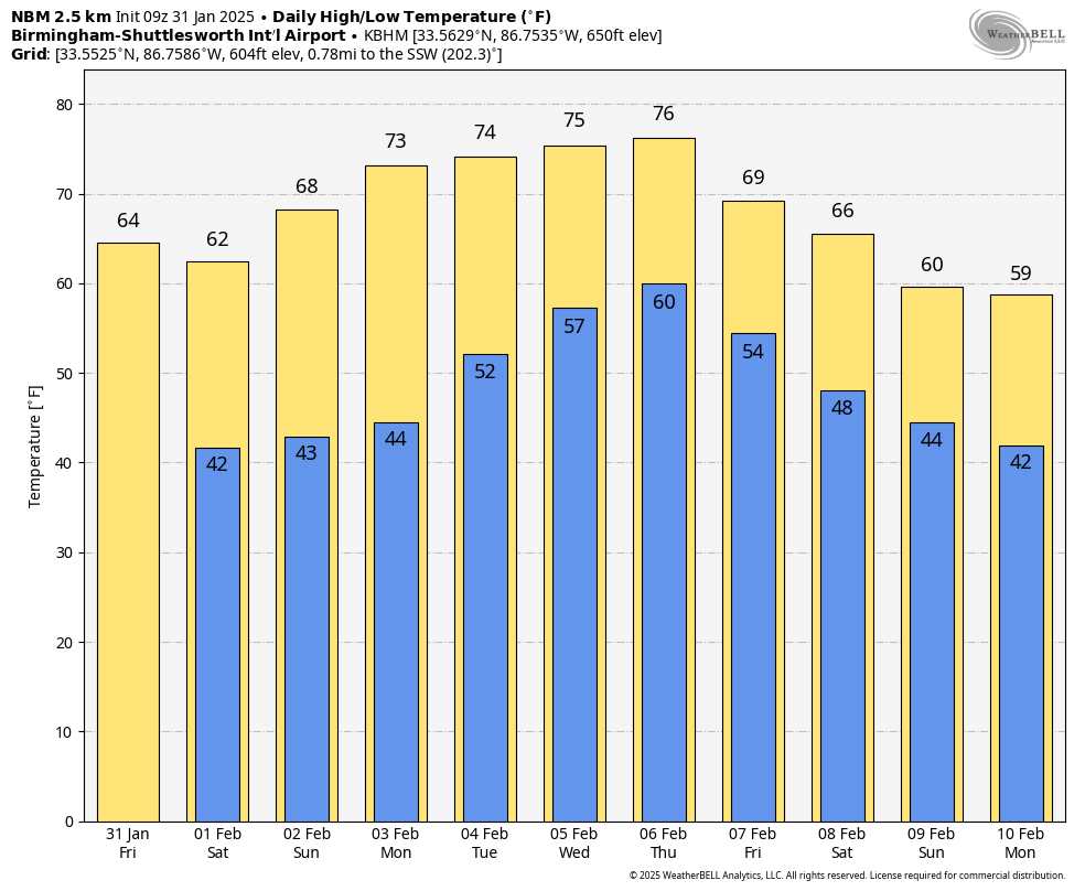
ON THIS DATE IN 1989: The barometric pressure at Norway, Alaska, reached 31.85 inches (1,078.4 millibars), establishing an all-time record for the North American continent. The temperature at the time of the record was about 46 degrees below zero. The severe Arctic cold began to invade the north-central U.S. The temperature at Grand Fall, Montana, plunged 85 degrees in 36 hours.
For more weather news and information from James Spann and his team, visit AlabamaWx.


