James Spann: Warm, humid days for Alabama; Maria over Puerto Rico
James Spann: Alabama stays very warm, with a few scattered showers, as Maria hits Puerto Rico from Alabama NewsCenter on Vimeo.
FOGGY START: We have a dense fog advisory in effect this morning for much of central and east Alabama; some of the lowest visibilities are in places like Anniston and Gadsden. Conditions will improve by midmorning.
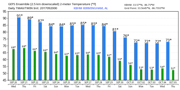
An upper ridge will keep Alabama very warm for the rest of the week, with highs in the 87- to 90-degree range most afternoons. There will be sufficient moisture and instability for a few afternoon/evening showers or storms, but they should be fairly isolated because of warm air aloft. Otherwise, expect partly sunny days and fair nights.
A pocket of colder air aloft moved over the state yesterday, bringing a number of showers and strong storms; one storm was severe over eastern Calhoun County and produced lots of tree damage near White Plains and Iron City, east of Anniston.
THE ALABAMA WEEKEND: Not much change — partly sunny, warm days, fair nights and just a few isolated afternoon and evening showers and thunderstorms Saturday and Sunday. Highs will be in the upper 80s.
FOOTBALL WEATHER: For Friday night’s high school games, it will be warm and humid, with temperatures falling from the low 80s at kickoff into the upper 70s by the final whistle. Just a slight risk of a shower during the first quarter.
Alabama will be in Nashville Saturday to take on the Vanderbilt Commodores (2:30 p.m. kickoff). The sky will be mostly sunny with a kickoff temperature near 88 degrees, falling into the mid 80s by the fourth quarter. Just a small risk of a brief shower.
Auburn is also on the road, playing Missouri in Columbia Saturday evening (6:30 p.m. kickoff). We expect a clear sky with temperatures falling from 84 degrees at kickoff into the upper 70s by the final whistle.
And UAB is also traveling this weekend, playing North Texas Saturday evening (5:30 p.m. kickoff) in Denton. The weather will be dry with a fair sky; about 90 degrees at kickoff, falling through the 80s during the game.
NEXT WEEK: We will roll with a persistence forecast — highs in the mid to upper 80s, with only a few isolated showers or storms during the afternoon and evening hours. But we continue to see evidence that an upper trough will replace the ridge in 10 days or so, pulling down cooler air as October begins.
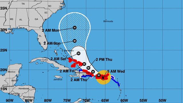
MARIA MAKES LANDFALL: Maria made landfall this morning on the southeast Puerto Rico coast at Yabucoa as a powerful category 4 hurricane; maximum sustained winds were 155 mph. Peak gusts reported early this morning were:
- 137 mph, Isla Culebrita
- 116 mph, El Negro
- 115 mph, Gurabo
- 113 mph, Yabucoa Harbor
- 100 mph, Del Rey
Maria will begin to turn north within 36 hours and is expected to move northward, east of the Bahamas, this weekend.
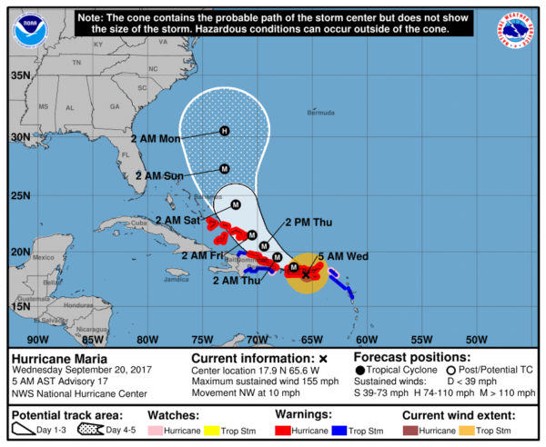
Global model ensemble output suggests Maria will remain east of the U.S. Atlantic coast, but there is always some uncertainty beyond five days. There is a decent chance Tropical Storm Jose, off the upper U.S. Atlantic coast, will leave a weakness in the sub-tropical ridge, allowing Maria to escape without touching the coast
BEACH FORECAST: Click here to see the AlabamaWx Beach Forecast Center page.
WEATHER BRAINS: You can listen to our weekly 90-minute netcast anytime on the web, or on iTunes. This is the show all about weather featuring many familiar voices, including meteorologists at ABC 33/40.
CONNECT: You can find me on all of the major social networks:
Facebook
Twitter
Google Plus
Instagram
Pinterest
Snapchat: spannwx
For more weather news and information from James Spann and his weather team, visit Alabama Wx.


