James Spann: Soggy air mass over Alabama; eyes on the Gulf
James Spann with the Tuesday forecast and the latest on the Tropics from Alabama NewsCenter on Vimeo.
MUGGY LATE MAY DAYS: Alabama’s weather won’t change much through Friday as moist, unstable air hangs over the Deep South. Today we project a mostly cloudy sky with scattered to numerous showers and storms; temperatures will struggle to reach the low 80s with only a limited amount of sun. Tomorrow through Friday the sun will be out at times, but once again we will deal with scattered showers and storms, most active during the afternoon and evening hours. Highs should be in the low to mid 80s on these three days.
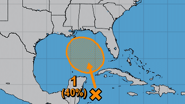
POTENTIAL TROPICAL SYSTEM FOR THE HOLIDAY WEEKEND: Global models continue to develop a tropical low in the northern Gulf of Mexico Saturday, but there is little agreement in details. The Global Forecast System model brings a broad low into the Florida Peninsula, then curving to the northwest in Alabama Monday. On the other hand, the European model (ECMWF) brings the low into the Mississippi coast Saturday, with a slow northward progression through Monday. Currently, the National Hurricane Center gives this a 40 percent chance of becoming a tropical storm or depression.

One way or another, the main impact will be enhanced rain coverage across the Gulf Coast states over the long holiday weekend. Guidance from NOAA’s Weather Prediction Center shows potential rain of 4-6 inches for places like Mobile, Gulf Shores and Pensacola, with 3- to 4-inch totals for places like Birmingham, Tuscaloosa and Anniston.

So, at this point, the holiday weekend looks mostly cloudy with occasional rain and a few thunderstorms. Even with the tropical low there will be some decent breaks in the rain, and the sun could break out at times. Highs will be in the 78- to 82-degree range.
MEMORIAL DAY WEEKEND ON THE GULF COAST: Needless to say, at this point the weather looks unsettled if you are beach bound for the long weekend. Here are the key points:
- Although parts of the Gulf Coast will see enhanced rain over the weekend, there is still much uncertainty with the potential tropical system, so the location of the heaviest rain could easily change over the next few days. Where the heaviest rain does fall, we could see some flooding.
- You might get a bit of sun in from time to time, but the sky will be generally cloudy on the coast Saturday through Monday from Gulf Shores east to Panama City Beach, with occasional rain.
- It is unlikely that the system in the Gulf becomes a dangerous tropical storm or hurricane; the most likely scenario is a tropical depression, or weak tropical storm. One way or another, rain will be the big issue, not wind.
- Dangerous rip currents will become an issue as the low in the Gulf develops; heed the warning flags that will be flying on the beaches.
Click here to see the AlabamaWx Beach Forecast Center page.
NEXT WEEK: Deep tropical moisture stays in place, and we will maintain some risk of showers and storms daily Tuesday through Friday with highs mostly in the 80s.
SPRING TORNADO SEASON WRAPS UP: On a positive note, based on the forecast upper-air pattern I think we can stick a fork in the spring tornado season for Alabama. There should be no risk of tornadoes through the rest of May, unless the tropical system in the Gulf brings a small spin up somewhere down south (which at this point looks unlikely). Typically the only tornado threat in Alabama in summer comes from tropical systems moving up from the south, and they tend to be fairly weak and short-lived.
WEATHER BRAINS: You can listen to our weekly 90-minute netcast any time on the web, or on iTunes. This is the show all about weather featuring many familiar voices, including meteorologists at ABC 33/40.
CONNECT: You can find me on all of the major social networks:
Facebook
Twitter
Google Plus
Instagram
Pinterest
Snapchat: spannwx
For more weather news and information from James Spann and his team, visit AlabamaWx.


