James Spann: Strong storms for Alabama this evening
RADAR CHECK: We have a number of showers and strong thunderstorms across Alabama this afternoon, some producing heavy rain. A Flash Flood Watch remains in effect for much of the state through tonight.
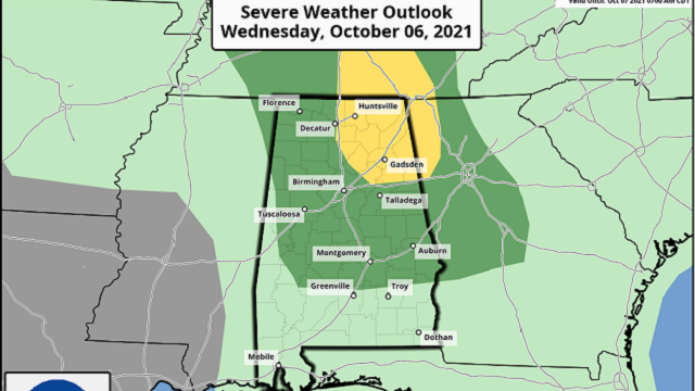
Also, there is a risk of severe storms across northeast Alabama through the evening; the Storm Prediction Center has defined a slight risk (level 2 of 5) for the northeast counties of the state, including places like Huntsville, Scottsboro, Fort Payne, Guntersville, Oneonta, Gadsden, Centre and Anniston. A marginal risk (level 1 of 5) extends as far south as Camden, Greenville and Eufaula.
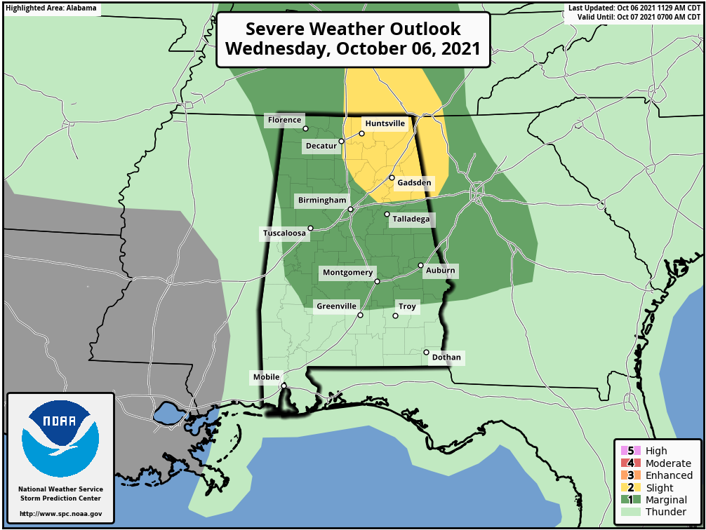
Storms this evening in the slight-risk area could produce a brief, isolated tornado or two. Hail is possible in the storms across the marginal-risk area. Showers and storms will weaken after sunset as the air becomes more stable.
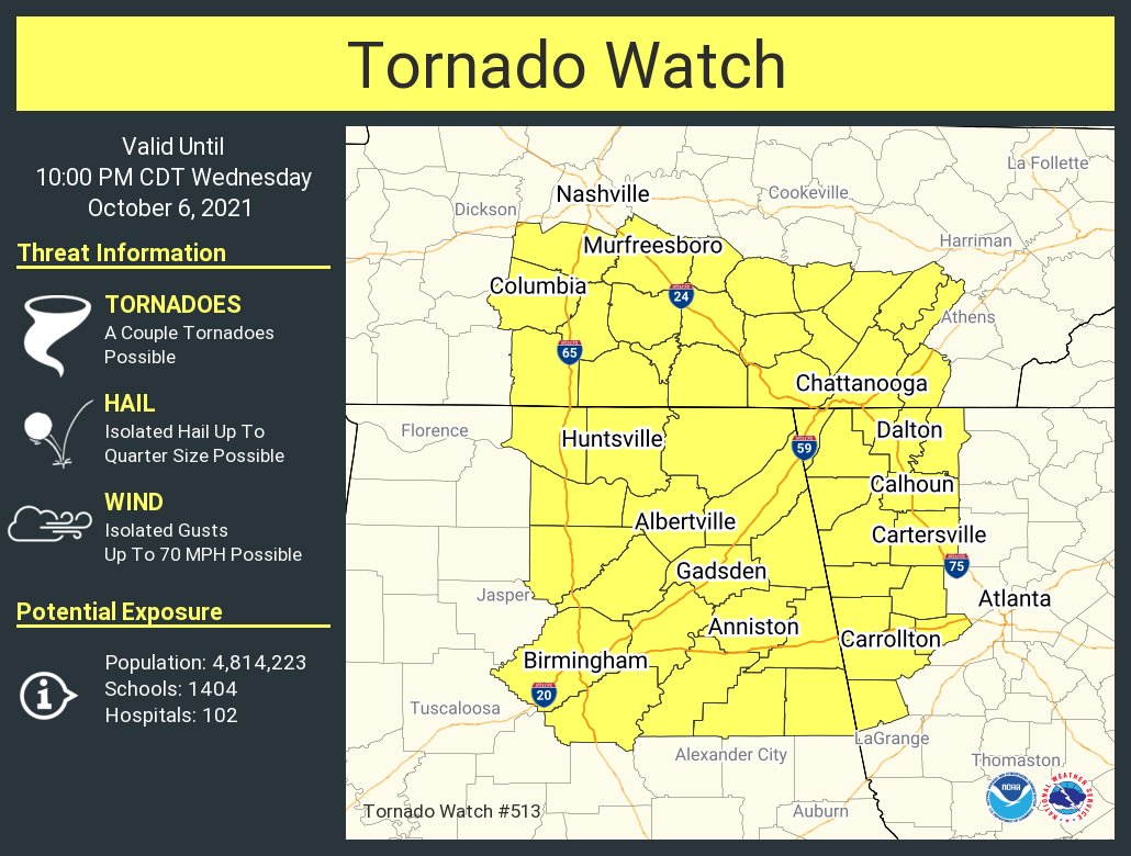
A Tornado Watch has been issued for northeast Alabama until 10 p.m.
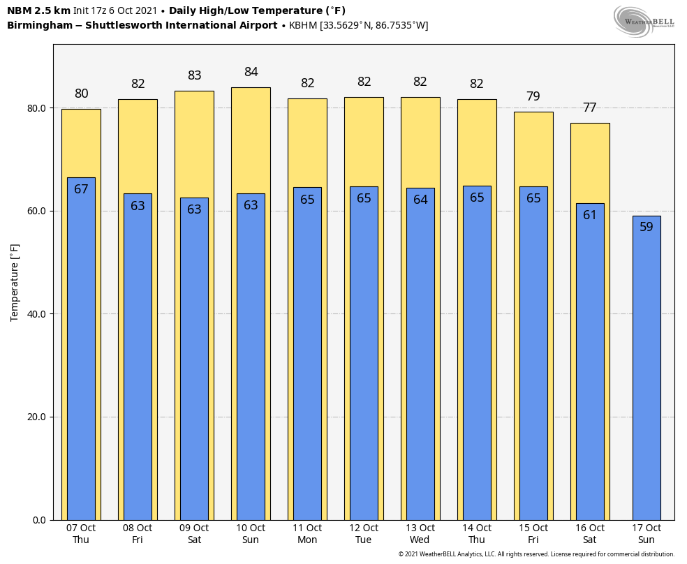
 The upper low west of the state will lift northward Thursday and weaken, but scattered to numerous showers and storms are still a good possibility across Alabama with a mix of sun and clouds; the high will be around 80 degrees.
FRIDAY AND THE WEEKEND: Any lingering showers across east Alabama will end very early Friday morning; the sky becomes partly sunny as dry air rolls into the state. The weekend will be warm and dry with a good supply of sunshine Saturday and Sunday. The high will be in the low 80s Friday, followed by mid 80s Saturday and Sunday.
NEXT WEEK: New global model data shows dry weather for most of the state through the entire week as an upper ridge builds across the Deep South. Highs will be mostly in the low 80s.
 TROPICS: The Atlantic basin is very quiet. A disturbance north of the Bahamas has only a 10% chance of developing over the next five days; that is the only feature of interest. The Gulf of Mexico is quiet and will remain quiet through the weekend.
FOOTBALL WEATHER: The sky will be clear for the high school games Friday night with temperatures falling through the 70s.
For the college games Saturday:
GEORGIA AT AUBURN (2:30 p.m. kickoff at Jordan-Hare Stadium): It will be a sunny, warm afternoon in east Alabama; expect a kickoff temperature near 83 degrees, falling into the upper 70s by the fourth quarter.
FLORIDA ATLANTIC AT UAB (2:30 p.m. kickoff at Protective Stadium in Birmingham): Sunny and warm; 83 degrees at kickoff, falling to about 76 by the final whistle.
STEPHEN F. AUSTIN AT JACKSONVILLE STATE (3 p.m. kickoff at Burgess-Snow Field): Sunny and warm with 82 degrees at kickoff, falling into the mid 70s by the fourth quarter.
SOUTH ALABAMA AT TEXAS STATE (6 p.m. CT kickoff in San Marcos, Texas): The sky will be clear; temperatures fall from about 88 at kickoff to near 76 by the final whistle.
GEORGIA SOUTHERN AT TROY (6 p.m. kickoff at Veterans Memorial Stadium): The sky will be clear with temperatures falling from 80 degrees at kickoff into the low 70s by the fourth quarter.
ALABAMA AT TEXAS A&M (7 p.m. CT kickoff at Kyle Field in College Station): Expect a clear sky with temperatures falling from 85 at kickoff into the mid 70s by the final whistle.
ON THIS DATE IN 2010: A significant severe weather event struck northern Arizona with at least eight confirmed tornadoes, the most tornadoes to hit Arizona in a single day. An EF2 tornado was on the ground for 34 miles, ranking as the longest-tracked tornado in Arizona history.
ON THIS DATE IN 2016: The center of Category 4 Hurricane Matthew passed within 100 miles of Miami.
BEACH FORECAST: Click here to see the AlabamaWx Beach Forecast Center page.
WEATHER BRAINS: You can listen to our weekly 90-minute show any time on your favorite podcast app. This is the show all about weather featuring many familiar voices, including the meteorologists at ABC 33/40.
CONNECT: You can find me on the major social networks:
For more weather news and information from James Spann and his team, visit AlabamaWx.


