James Spann: Alabama’s long dry spell to continue; Ian is inland
DRY DAYS CONTINUE: Alabama’s weather just won’t change much through next week as the dry conditions continue. Look for sunny, pleasant days and clear, cool nights; highs will be in the mid to upper 70s through Monday and in the low 80s by the middle of next week. Lows will be mostly in the 50s. There’s still no evidence of any serious rain event around here for at least the next 10 days.
October is our driest month of the year, so weather like this isn’t too unusual.
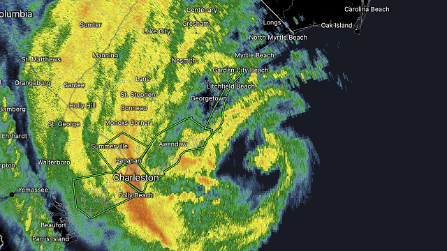
 TROPICS: Hurricane Ian made landfall this afternoon at 1:05 p.m. CT near Georgetown, South Carolina, with winds of 85 mph. The system will weaken quickly tonight as it moves inland. Elsewhere, a tropical wave is producing disorganized showers and thunderstorms over the far eastern tropical Atlantic. Environmental conditions are forecast to be conducive for gradual development of this system, and a tropical depression could form early next week as the system moves westward to west-northwestward over the eastern tropical Atlantic. It’s too early to know whether this will be a threat to any land area..
FOOTBALL WEATHER: For the high school games in the state tonight, the sky will be mostly clear with temperatures falling through the 60s.
Saturday, Alabama travels to Fayetteville to take on Arkansas (2:30 p.m. CT kickoff). The sky will be sunny with a temperature around 80 degrees as the game begins. There’s no risk of rain.
Auburn hosts LSU Saturday (6 p.m. kickoff) at Jordan-Hare Stadium. The sky will be mostly fair with temperatures falling from near 72 at kickoff into the 60s during the game.
UAB will be in Houston to take on Rice (6:30 p.m. CT kickoff). The sky will be clear with temperatures falling from the low 80s at kickoff into the mid 70s by the final whistle.
RACE WEEKEND: The weekend looks great for Talladega as Ian stays to the east. Expect a good supply of sunshine Saturday and Sunday with highs in the mid to upper 70s.
ON THIS DATE IN 1896: A hurricane formed on Sept. 22 and lasted until Sept. 30. It formed directly over the Lesser Antilles and hit Cuba, Florida, Georgia, South and North Carolina, Virginia, Washington, D.C., and Pennsylvania. Its maximum sustained winds were at 130 mph. The heaviest rainfall deposited in association with the storm was 19.96 inches at Glennville, Georgia. This hurricane was responsible for an estimated 130 deaths.
BEACH FORECAST: Click here to see the AlabamaWx Beach Forecast Center page.
For more weather news and information from James Spann and his team, visit AlabamaWx.


