James Spann: Rain returns to Alabama Friday, more cold air for the weekend
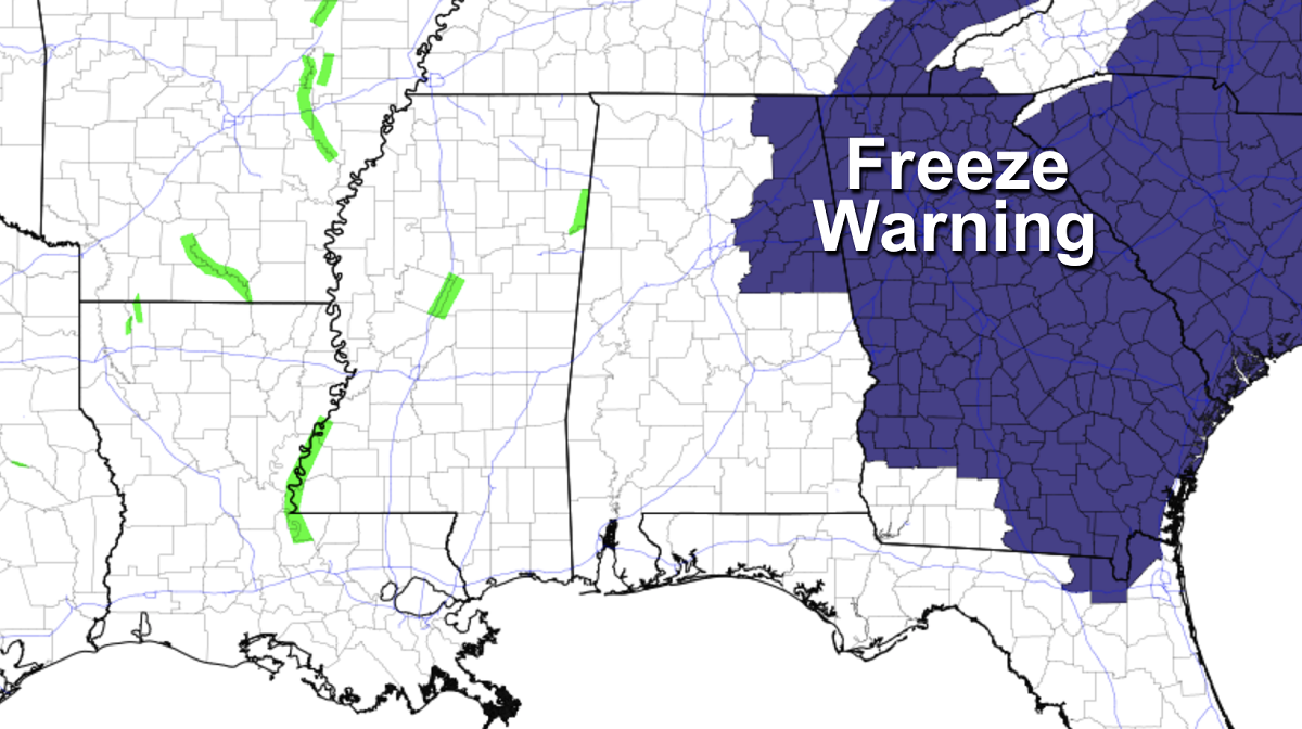
SUNNY AFTERNOON: Temperatures are in the 50s across most of Alabama this afternoon, with a few spots in the low 60s. We have a cloudless sky, and tonight will be clear and cold again, with lows in the 30s and 40s. A freeze warning is in effect tonight for northeast Alabama, where lows will be between 28 and 32 degrees. Frost is a good possibility for the rest of north and central Alabama early Thursday.
Look for a nice warm-up Thursday; with a good supply of sunshine expect a high between 68 and 73 degrees. Clouds increase Thursday night.
FRIDAY: Rain returns to the state as a cold front passes through. The Storm Prediction Center maintains a slight risk (level 2 out of 5) of severe thunderstorms for the southwest corner of the state, including places like Mobile, Gulf Shores, Jackson and Atmore. A marginal risk (level 1) extends as far north as Greensboro and Auburn.
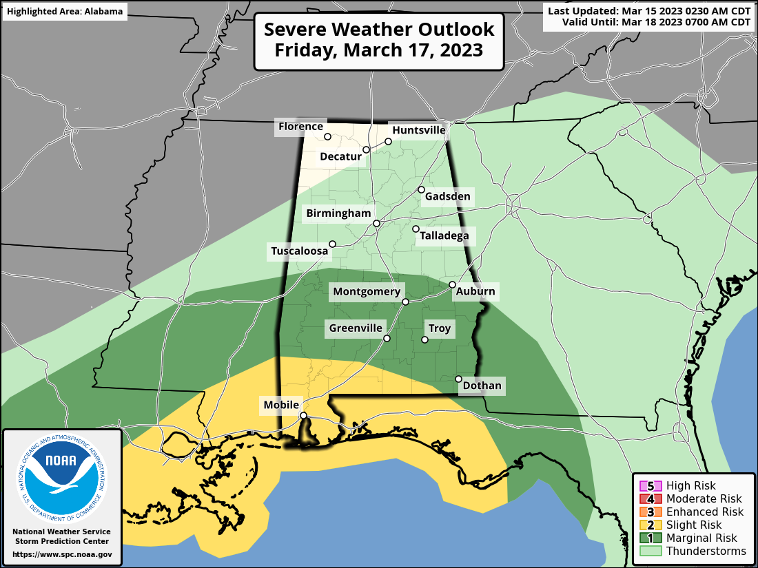
The core risk of heavy storms Friday will be near the Gulf Coast, where some surface-based instability will be available. The main threat will come from strong, gusty winds; an isolated tornado can’t be ruled out. But most of the state will simply have a cool, rainy day in a stable air mass. Rain amounts Friday will average around 1 inch, with isolated heavier totals. Temperatures will be in the 60s during the morning but will fall through the 50s and into the 40s over the northern half of the state by afternoon following the frontal passage.
THE ALABAMA WEEKEND: Another shot of cold air rolls into the Deep South over the weekend. Temperatures will be in the low to mid 30s early Saturday with a brisk north wind. The sky will become sunny Saturday with a high in the 50s. Clear weather is the story Sunday with another late-season freeze during the early morning; lows will dip into the 24- to 34-degree range. The high Sunday will be in the 50s again, about 10-15 degrees below average.
NEXT WEEK: Another freeze is likely early Monday with a low in the upper 20s and low 30s. The day will be mostly sunny with a high in the 50s and 60s. Then a low forms in the northeast Gulf of Mexico and rain is possible statewide Tuesday, but model consistency on this event remains poor. If we see precipitation, it will be a cold rain with temperatures only in the 40s and 50s. Rain will end Wednesday morning as the low moves northeast. Thursday looks dry at this point, followed by a chance of showers Friday. Temperatures will likely reach the 70s by the end of the week.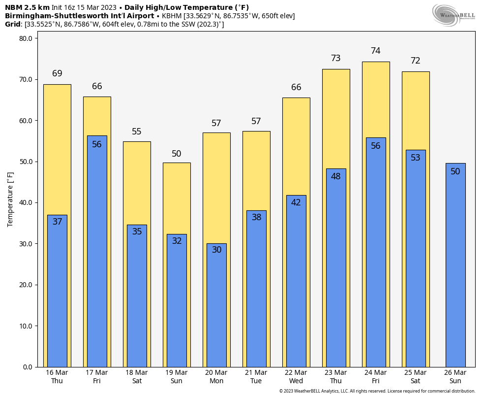
THIS MORNING: Here are some lows across Alabama early this morning:
- Ashville — 20
- Tuckers Chapel — 21
- Margaret — 23
- Fort Payne — 24
- Carbon Hill — 24
- Gadsden — 24
- Concord — 25
- Helena — 26
- Heflin — 26
- Cottondale — 26
- Anniston — 27
- Thorsby — 27
- Cullman — 27
- Taylorville — 27
- West Blocton — 27
- Birmingham — 28
- Coker — 29
- Huntsville — 29
- Alabaster — 29
- Tuscaloosa — 30
- Montgomery — 30
- Northport — 30
- Mountain Brook — 31
- Muscle Shoals — 32
- Dothan — 35
- Mobile — 38
ON THIS DATE IN 1938: A tornado hit McPaul, Iowa, while moving from southeast to northwest. Another one raced through Batesville, Illinois, at 60 to 65 mph. Another tornado causing F4 damage killed 10 and injured 12 in St. Clair County, Missouri. This tornado was part of an outbreak that produced four tornadoes and was responsible for 11 deaths and 42 injuries.
ON THIS DATE IN 2008: An F2 tornado moved through southern Cherokee County, north of Piedmont. The damage was consistent with winds near 115 mph; thankfully there were no injuries.
BEACH FORECAST: Click here to see the AlabamaWx Beach Forecast Center page.
For more weather news and information from James Spann and his team, visit AlabamaWx.


