James Spann: Falling temperatures for Alabama today, with some rain at times
James Spann forecasts colder air moving into Alabama today from Alabama News Center on Vimeo.
SHARP COLD FRONT MOVES THROUGH TODAY: Just before sunrise, temperatures were in the upper 60s across much of Alabama with a cloudy sky and gusty south wind. A sharp cold front will move through the state today with a few showers and possibly a thunderstorm. But there is no risk of severe storms, despite a sharp thermal contrast associated with the front.
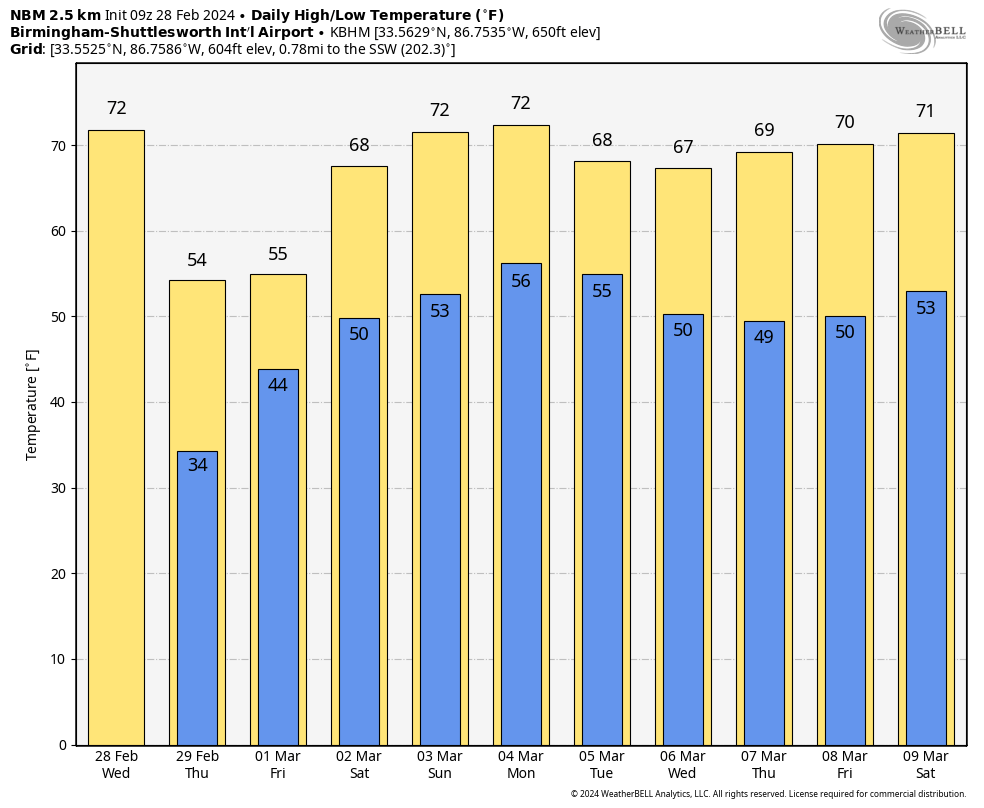
Temperatures will drop into the upper 40s behind the front this morning over the northern third of the state with a chilly north wind, but the southern half of the state will see potential for 80-degree warmth by midday and early afternoon before the front arrives. As the front passes, temperatures will drop 15-20 degrees very quickly.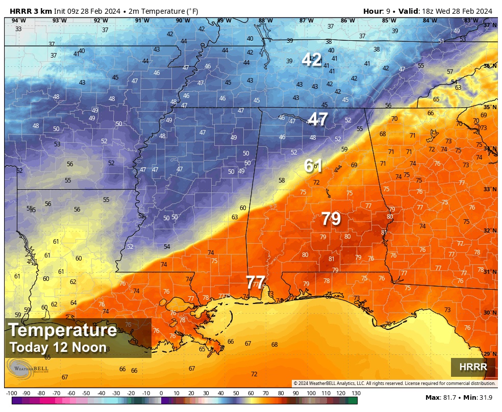 The sky will clear tonight, and temperatures drop into the 30s early Thursday morning. A few spots across north Alabama could see a freeze.
THURSDAY/FRIDAY: Thursday will be cool and dry with a partly sunny sky and a high in the 50s. Clouds return Thursday night, and a disturbance will bring periods of rain on Friday. The weather stays cool, with temperatures holding in the 50s during the day Friday.
THE ALABAMA WEEKEND: Expect a warming trend over the weekend; highs will be between 67 and 72 degrees Saturday and in the 70s statewide Sunday. It now looks like a decent part of the state will be dry Saturday with only isolated showers; the best chance of seeing some rain will be near the Gulf Coast. On Sunday we will mention a chance of scattered showers statewide, but nothing really heavy or widespread.
NEXT WEEK: Occasional showers and a thunderstorm or two are likely Monday with the approach of a cold front. The front will likely stall out somewhere across Alabama, keeping the chance of rain in the forecast basically daily through Friday. It certainly won’t rain all day every day, but the week looks fairly wet and unsettled. Highs through the week will be mostly in the upper 60s and low 70s.
 ON THIS DATE IN 1962: Wilmington, North Carolina, reached a high temperature of 85 degrees. This is the warmest temperature on record during February.
ON THIS DATE IN 2007: A severe storm blew into France, Portugal and Spain, smashing sea walls, destroying homes, polluting farmland with salt water and devastating the Atlantic coast’s oyster farms. Winds reached about 125 mph on the summits of the Pyrenees and up to nearly 100 mph along the Atlantic Coast. Wind speeds of 106 mph were measured atop the Eiffel Tower in Paris.
ON THIS DATE IN 2011: Five short-lived tornadoes touched down across Alabama, including an EF-1 near Tyson in Lowndes County, just west of I-65.
For more weather news and information from James Spann and his team, visit AlabamaWx.


