Scott Martin: Dry, hot day for Alabama, with no rain in sight this week
THIS WEEK: A dry easterly flow will be over Alabama today, which will keep us dry and less humid. However, we’ll have a mix of sun and clouds throughout the day, and afternoon highs will be in the upper 80s to the lower 90s. We’ll keep the dry streak going on Juneteenth as we continue to have drier air move in. While it may be cloudy at times, no rain is in the forecast, and highs will top out in the upper 80s to the lower 90s. Skies clear out mostly on Thursday, and that will allow afternoon highs to rise a few degrees warmer. We stay dry with mostly sunny skies and highs in the upper 80s to mid 90s. It will feel like summer on the actual first day of summer. We go a touch hotter on Friday; most will see highs in the lower to mid 90s, with a few locations reaching the upper 90s. We’ll continue the dry streak as well with sunny skies.
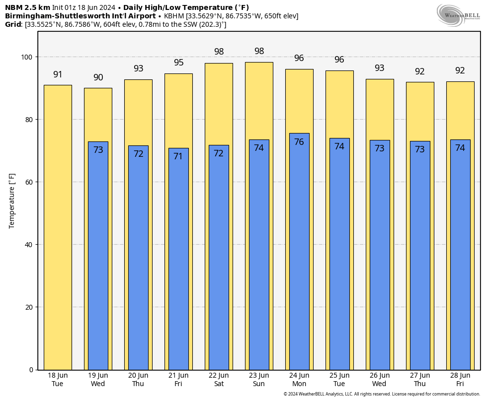
THE ALABAMA WEEKEND: Hot, dry weather continues on Saturday, with sunny skies and highs in the mid to upper 90s for most. Moisture will start to build on Sunday, and you’ll notice humidity values rise. Skies will be sunny through the morning, but with the increasing moisture, we’ll see clouds begin to build in the afternoon. However, we’ll stay dry, with highs in the lower to mid 90s.
NEXT WEEK: Skies will be mostly sunny to start Monday, but as the daytime heating builds into the afternoon, clouds will begin to build, and we’ll have a good chance of scattered showers and storms. We’ll have a decent bit of instability in place, so a few stronger storms will be possible, with gusty winds. It’s way too early to determine whether there will be a threat of severe weather. Highs will be in the mid to upper 90s for most. After that, it looks like active weather to finish out the last week of June, especially if the European model is correct in the potential for some tropical mischief by midweek.
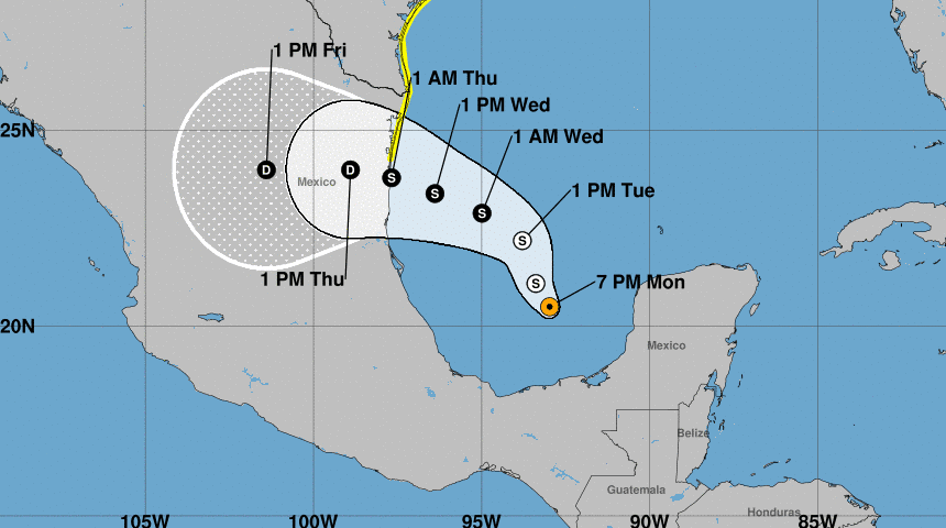
TROPICS: Potential Tropical Cyclone 1 formed Monday afternoon and is expected to bring heavy rains and coastal flooding to northeastern Mexico and Texas starting Tuesday. A tropical storm watch is in effect for the Texas coast from Port O’Connor to the mouth of the Rio Grande, and the northeastern coast of Mexico south of the mouth of the Rio Grande to Boca de Catan. Tropical storm conditions are possible in the watch area within 48 hours. The system is moving north-northwest, and this motion is expected to continue through Tuesday. It is likely to turn west-northwest by Tuesday night or Wednesday, approaching the western Gulf Coast late Wednesday. Maximum sustained winds are near 40 mph, with the system forecast to become a tropical storm by Wednesday.
Five to 10 inches of rainfall is expected across northeast Mexico into southeastern Texas, with up to 15 inches in some areas. This could cause flash and urban flooding, river flooding and mudslides in higher terrain of northeast Mexico. Storm surge potential includes Sargent, Texas, to Sabine Pass, Texas, at 2-4 feet, Galveston Bay at 2-4 feet, the mouth of the Rio Grande, Texas, to Sargent, Texas, at 1-3 feet, and Sabine Pass, Texas, to Vermilion/Cameron parish line, Louisiana, at 1-3 feet. The chance of formation is 80%.
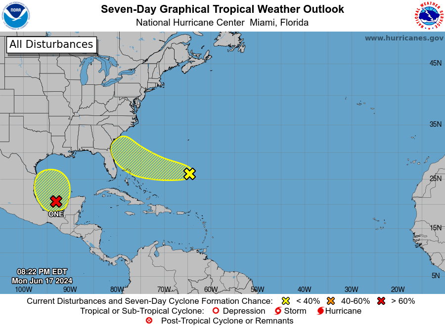
In the southwestern Atlantic Ocean, we’re keeping an eye on an area of cloudiness and thunderstorms several hundred miles east of the Bahamas. The system is expected to move westward or west-northwestward, approaching the southeastern U.S. coast by Friday. The chance of formation over the next seven days is 20%.
Meanwhile, in the southwestern Gulf of Mexico, another broad area of low pressure is expected to develop this weekend. Early next week, conditions could become conducive for gradual development as it moves slowly northward or northwestward. The chance of formation through the next seven days is 20%.
For more weather news and information from James Spann, Scott Martin and other members of the James Spann team, visit AlabamaWx.


