Scott Martin: Hot, dry weekend for Alabama; potential tropical mischief next week

SATURDAY: High pressure continues to build from the northeast, extending our streak of dry weather. Expect partly to mostly sunny skies with a few clouds overhead; afternoon highs will range from the lower to mid-90s. If you’re attending outdoor events like football games or festivals, make sure to stay hydrated, as it will be quite warm.
SUNDAY: The high-pressure system remains in place, keeping our weather dry through Tuesday night. Skies will be mostly sunny with highs again in the lower to mid-90s. Although Sunday marks the first official day of fall, it won’t feel like it with these warm temperatures.
THE WORK WEEK: High pressure holds steady Monday, continuing the dry, hot pattern. Expect highs in the upper 80s to lower 90s.
A trough will begin moving in from the west on Tuesday. While we remain dry, we may see a few more clouds, with partly to mostly sunny skies. Highs will range from the mid-80s to lower 90s.
A tropical system is expected to develop in the Gulf of Mexico Wednesday, while the trough pushes a surface front into the region. With increasing moisture, we could see a few isolated afternoon showers or storms, but the extent depends on what happens in the Gulf. The Global Forecast System (GFS) model suggests the tropical system may stay weak, with minimal rain making it to the Gulf Coast. Highs will be in the lower 80s to lower 90s.
By Thursday, the surface front will have moved through, bringing cooler, drier conditions to the state. While the GFS shows a more organized tropical system approaching the Gulf Coast, it is expected to get caught up in the front and move northeast, away from Alabama’s beaches. Highs will range from the upper 70s to lower 80s.
As the tropical system is forecast to make landfall around Florida’s Big Bend area, we should experience mostly dry, pleasant weather across the region on Friday. However, there is a chance of a few scattered showers in southeastern Alabama, depending on the system’s path. Highs will remain in the upper 70s to lower 80s.
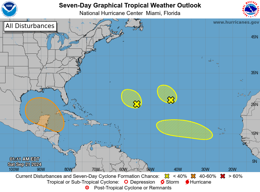
TROPICS: A broad area of low pressure could form next week over the northwestern Caribbean Sea, with gradual development possible. A tropical depression may form as the system moves slowly north or northwest into the southern Gulf of Mexico. Regardless of development, expect heavy rain in Central America. The chance of formation through seven days is 60%.
In the Atlantic, remnants of Gordon are more than 1,000 miles southwest of the Azores. Strong upper-level winds are displacing showers and thunderstorms from the center, limiting significant development as it meanders in the subtropical Atlantic.
A tropical wave is expected to move off the coast of Africa Sunday or Monday. Gradual development is possible next week as it tracks west-northwestward across the eastern tropical Atlantic.
For more weather news and information from James Spann, Scott Martin and other members of the James Spann team, visit AlabamaWx.


