James Spann: Helene now a hurricane and growing stronger; heavy rain ahead for eastern Alabama
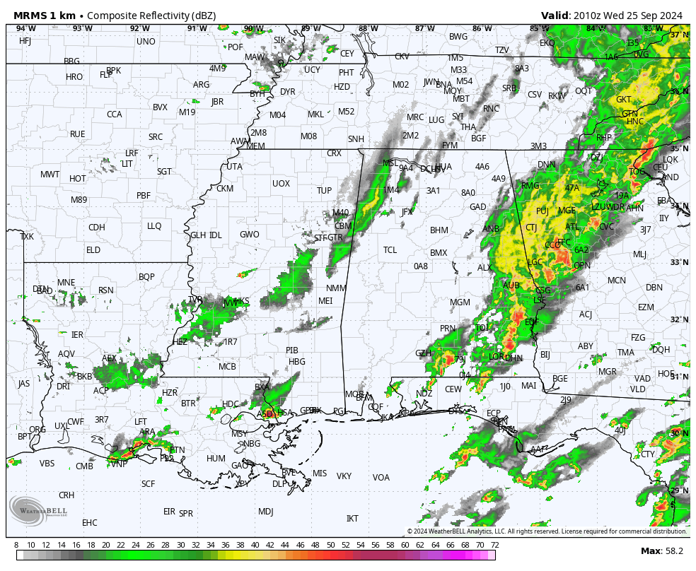
RADAR CHECK: Rain and storms are most active across east and southeast Alabama this afternoon. The rain is heavy in spots; a flash flood warning has been issued for parts of Chambers, Lee and Dale counties. In addition to heavy rain, stronger storms across east and southeast Alabama are capable of producing strong, gusty winds and small hail through the evening.
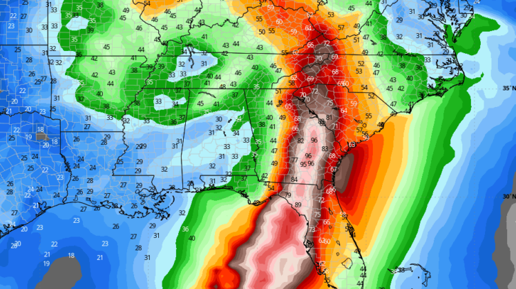
The chance of rain will continue through Thursday statewide. The rain becomes heavy Thursday night over the eastern third of the state as Helene moves inland; a flash flood watch is in effect from Scottsboro down to Anniston, Opelika, Montgomery, Troy and Dothan. Rain amounts will be much lighter over the western counties.
Winds increase Thursday night over east Alabama. Gusts to 30-35 mph are possible, with gusts to 40-45 mph possible from Eufaula down to Dothan.
The big rain mass will move out early in the day Friday, and we expect only a few isolated showers Friday afternoon and night, mainly over the Tennessee Valley.
The weekend will be mostly dry, with only a small risk of a shower both days over the northern half of the state. Highs will be between 77 and 82 degrees. Much of next week looks dry as well.
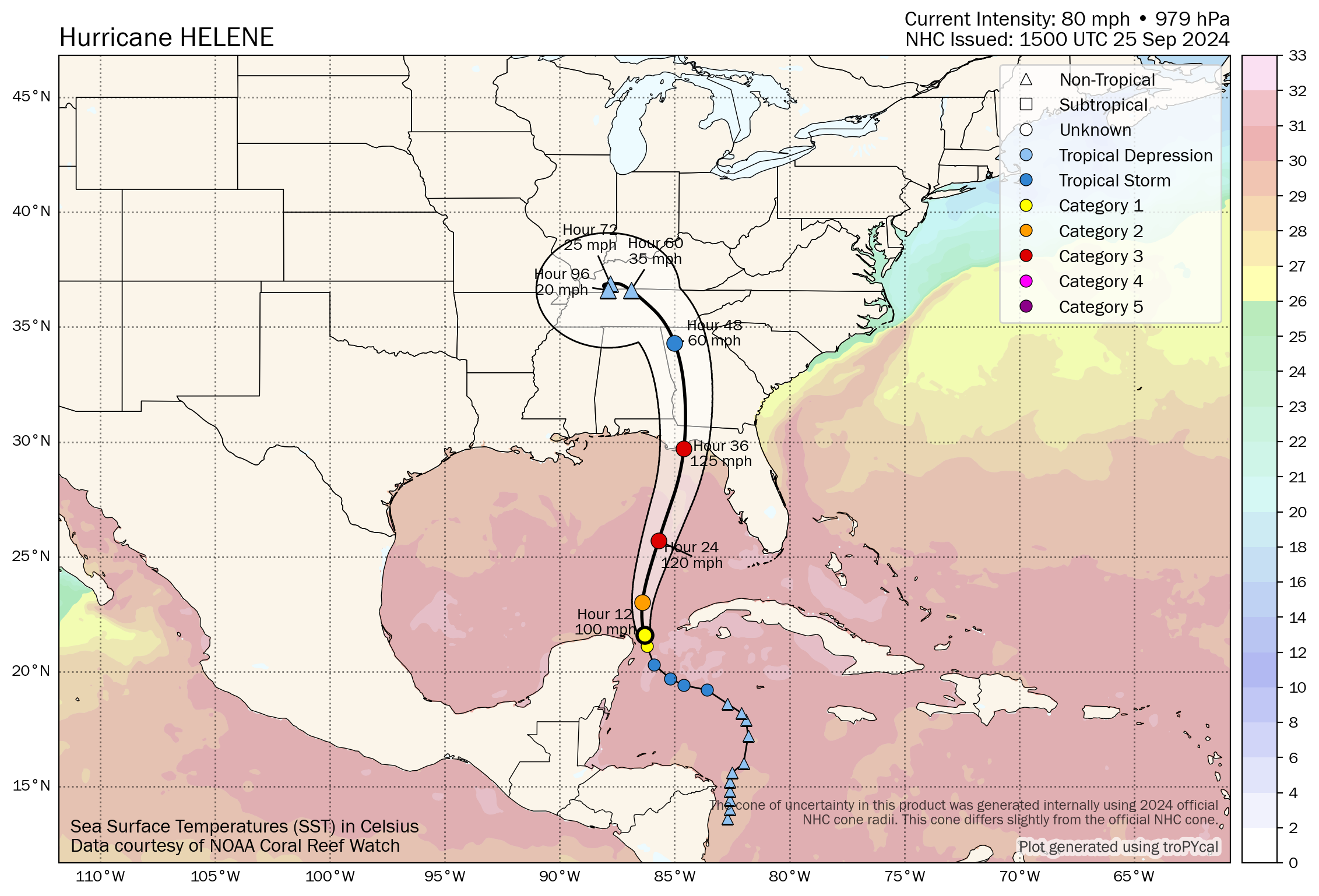
HELENE: Helene is now a hurricane with maximum sustained winds of 80 mph. The center is about 110 miles north/northeast of Cozumel. The hurricane is moving to the north/northwest at 10 mph.
Helene is expected to move over an environment of relatively low shear, strong upper-level divergence and sea-surface temperatures of 29-31 degrees Celsius, all of which should foster additional strengthening.
Indices indicate a high chance of rapid intensification during the next 24 hours, and as a result the National Hurricane Center intensity forecast shows Helene becoming a major hurricane by Thursday morning. There is still some uncertainty on exactly how strong Helene will get, and upward adjustments to the forecast intensity could be required in subsequent advisories if Helene rapidly intensifies more than forecast.
Regardless, Helene is forecast to be a large major hurricane (Category 3, with winds of 125 mph) when it reaches the Big Bend coast of Florida. As a result, storm surge, wind and rainfall impacts will likely extend well away from the center and outside the forecast cone, particularly on the east side. In addition, the fast forward speed while Helene crosses the coast will likely result in farther inland penetration of strong winds over parts of the southeastern United States after landfall, including strong gusts over higher terrain of the southern Appalachians.
Helene will likely make landfall Thursday evening on the Florida coast south of Tallahassee and east of Apalachicola. There has been very little change in the track forecast and the expected impact for inland areas over the past 48 hours.
Key messages:
- A hurricane warning remains in effect from Anclote River to Mexico Beach.
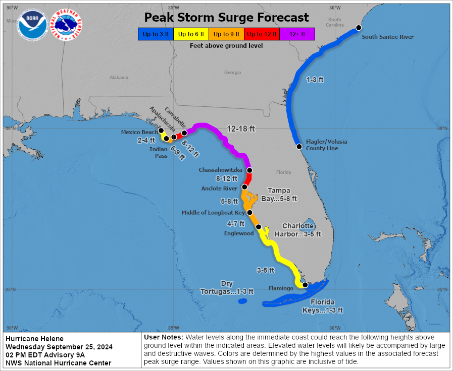
- A storm surge warning is in effect for Indian Pass southward to Flamingo, for Tampa Bay and for Charlotte Harbor.
- The central Gulf Coast (Gulf Shores to Panama City Beach) is expected to be on the good, west side of the circulation with an offshore flow. The hurricane warning includes Mexico Beach, Port St. Joe, Cape San Blas and points east. The main impact in terms of wind, storm surge, flooding and isolated tornadoes will be from east of Indian Pass to Cedar Key and down to Tampa Bay (the east side of the circulation).
- A 12- to 18-foot storm surge is forecast from the Ochlockonee River down to Chassahowitzka on the Florida coast. The storm surge around Tampa Bay is forecast to be 5-8 feet.
- The southeast corner of Alabama (around Dothan) could see wind gusts to 40-45 mph Thursday night. A tropical storm warning has been issued for parts of east and southeast Alabama, including places like Lafayette, Opelika, Eufaula, Troy, Ozark and Dothan. Tropical-storm-force winds begin at 39 mph. The rest of east Alabama will see gusts to 35 mph; gusts over the western half of the state will be 20-25 mph. The highest wind velocities will be east of Alabama over north Florida and Georgia, where numerous power outages are likely.
- The eastern half of Alabama has potential for 3-5 inches of rain through Friday morning; potential for the western counties is 1-2 inches. Areas in west and southwest Alabama from Tuscaloosa to Mobile are expected now to receive less than 1 inch. A flash flood watch is in effect for the eastern third of Alabama, in the area from Scottsboro down to Anniston, Opelika, Montgomery, Troy and Dothan.
- Tornadoes are not expected in Alabama. Any isolated tornadoes will be along the east of the center of circulation as Helene moves northward east of Alabama.
- The weather will improve across Alabama by midmorning Friday; we expect just a few isolated, light showers Friday night and Saturday over the northern third of the state. The weather won’t be bad at all for high school and college games in the state — just a small risk of a shower for any given stadium. Wind will be less than 10 mph.
Remember, any tropical forecast can change. Watch for updates.
ON THIS DATE IN 1998: Four hurricanes were spinning simultaneously in the Atlantic basin: Georges, Ivan, Jeanne and Karl. That was the first time this had happened since 1893.
For more weather news and information from James Spann and his team, visit AlabamaWx.


