James Spann: Severe weather threat overnight for Alabama
THIS AFTERNOON: We have a warm, dry afternoon across Alabama with temperatures generally in the 79- to 83-degree range. But, to the west, a dynamic storm system is producing thunderstorms over Arkansas, Louisiana and northeast Texas, and those will move into our state late tonight.
New high-resolution model data is suggesting potential for the line of storms to become more “cellular” after midnight in Alabama, and with high storm relative helicity values, we will need to hit the chance of a tornado or two a little harder. The limiting factor will be somewhat marginal instability values, but they are sufficient for severe storms.
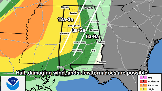
The Storm Prediction Center has a “slight risk” of severe weather defined for most of the state along and west of I-65, with a “marginal risk” to the east. Keep in mind this outlook runs through 7 a.m. tomorrow.

TIMING: The storms should enter West Alabama around midnight tonight, then pass eastward during the pre-dawn hours and finally move out of the state by 9 a.m. tomorrow. The storms should be in the Birmingham metro in the 3 a.m.-to-6 a.m. time frame.
THREATS: Heavier storms overnight will be capable of producing hail and damaging straight-line winds. A few tornados are possible as well, especially south of I-20.
RAIN: Rain amounts of around one-half inch are likely, with isolated heavier totals. No flooding issues.
CALL TO ACTION: Be sure you have a way of getting warnings, especially with an overnight event like this. A NOAA Weather Radio is the baseline, and a good smartphone app is the other tier. Identify the safe place in your home and be sure everyone knows where it is. In that safe place have helmets for everyone, along with hard-sole shoes and preferably a portable airhorn in case you need help.
Be sure you have the ABC 33/40 app on your phone so you can watch live severe weather coverage, if needed:
The sky becomes partly to mostly sunny tomorrow afternoon as drier air works into the state; the high will be in the 77- to 80-degree range.
FRIDAY/SATURDAY: These two days will be very warm and mostly dry; we will mention isolated, mostly afternoon and evening thunderstorms both days because of high instability values. Highs will be in the upper 80s; a few spots might even touch 90 degrees.
MORE STORMS SUNDAY: Another robust spring weather system will sweep into the state Sunday with a risk of strong to severe storms. The main window for severe weather, for now, seems to be in the noon-to-midnight time frame. Way too early to be specific about the magnitude of the threat; let’s get through the storms late tonight and then we can focus on Sunday.
NEXT WEEK: Monday and Tuesday will be dry with pleasant afternoons and cool nights; the next chance of showers and storms will come around Thursday, followed by more cool air.

Click here to see the Beach Forecast Center page.
WEATHER BRAINS: You can listen to our weekly 90-minute netcast anytime on the web, or on iTunes. This is the show all about weather featuring many familiar voices, including meteorologists at ABC 33/40.
CONNECT: You can find me on all of the major social networks:
Facebook
Twitter
Google Plus
Instagram
Pinterest
Snapchat: spannwx
For more weather news and information, visit AlabamaWX.


