James Spann: Very mild, showers return Thursday in Alabama
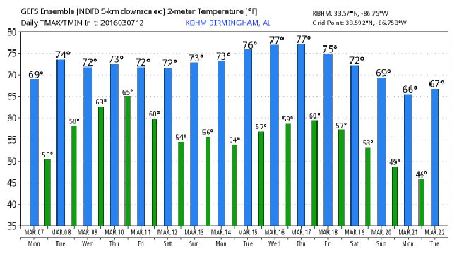
ANOTHER BEAUTIFUL AFTERNOON: Temperatures are pretty close to 70 degrees in most places this afternoon with a good supply of sunshine through scattered clouds. And, if you like the weather today, you should love the weather tomorrow; we don’t expect much change. A partly sunny sky with a high up in the middle 70s.
TO THE WEST: The dual threat of flash flooding and severe weather will be an issue for parts of Texas, Arkansas, and Louisiana through mid-week, but the upper system responsible for that will drop down into Mexico and won’t move much, meaning the big rains stay west of Alabama through Wednesday.

We will mention just a small risk of a shower near the Mississippi border Wednesday; the rest of our state should stay dry.
THURSDAY/FRIDAY: Showers are possible Thursday, especially over the western half of the state, and then the risk of showers and thunderstorms will increase statewide Friday. The good news is that the upper trough should be filling, and with weakening upper support we don’t expect any severe weather issues for now. Highs hold in the 70s both days.
THE ALABAMA WEEKEND: We will need to maintain the risk of showers, and possibly a thunderstorm, on Saturday with a good pool of moist air in place. But, it won’t rain all day, and we don’t expect any severe weather. The sun might even peek out a time or two. But, clearly the best day over the weekend will come on Sunday as the upper trough kicks out and drier air settles into the state. The sky should be partly to mostly sunny Sunday with a high close to 70 degrees.
NEXT WEEK: A passing disturbance could squeeze out a few showers Monday, but it doesn’t look like a big rain event, and the latest global models suggest dry and mild weather for mid-week. See the Weather Xtreme video for maps, graphics, and more details.

AT THE BEACH: About 7-9 hours of sunshine tomorrow and Wednesday… then a few showers or storms are possible Thursday through Saturday with a limited about of sunshine. Highs on the immediate coast will hold in the 60s because of the cooler ocean water; 70s are likely inland. See a very detailed Gulf Coast forecast here.
SPOTTER TRAINING IN JACKSONVILLE TOMORROW NIGHT: We are offering basic SKYWARN training at four locations across North/Central Alabama in March… the first comes tomorrow evening at 6:30 at the Jacksonville Community Center. Then, Storm Spotter Xtreme will be held on Saturday, April 9 at the BJCC from 9am to 2pm. This will feature both the basic and advanced SKYWARN classes, along with a session from Kevin Laws of the Birmingham NWS office. And, if you come, you get free admission to the Alabama International Auto Show, going on at the BJCC that same day. There is no cost and no need to register. Just show up with a curious mind. Kids 10 and older will also enjoy this if they love weather and want to learn more. Please help us make the severe weather warning process better!

WEATHER BRAINS: Don’t forget you can listen to our weekly 90 minute netcast anytime on the web, or on iTunes. This is the show all about weather featuring many familiar voices, including our meteorologists here at ABC 33/40.
CONNECT: You can find me on all of the major social networks…
Facebook
Twitter
Google Plus
Instagram
For more weather news and information from James Spann and his weather team, visit Alabama WX.


