James Spann: Severe storms possible tomorrow in Alabama
James Spann Alabama NewsCenter Weather Forecast March 23 from Alabama NewsCenter on Vimeo.
ACTIVE WEATHER AHEAD: Today will be dry and mild across the state with a high around 70 degrees; the sky will be cloudy at times as moisture levels rise. Severe storms are possible this afternoon and tonight in the broad zone from San Antonio to Chicago.
Then, tomorrow, the risk of severe weather will shift into Alabama and the Deep South. A deep surface low will be near Chicago, with a trailing cold front supported by a deep upper trough. Thermodynamics are “so-so”, with surface based CAPE values near 1,000 j/kg or higher from roughly I-20 south, but dynamics are pretty impressive with a low level jet of over 60 knots, and storm relative helicity (0-1 km) values over 200 m**2/s**2 over the northern half of the state.
Here is the current thinking…
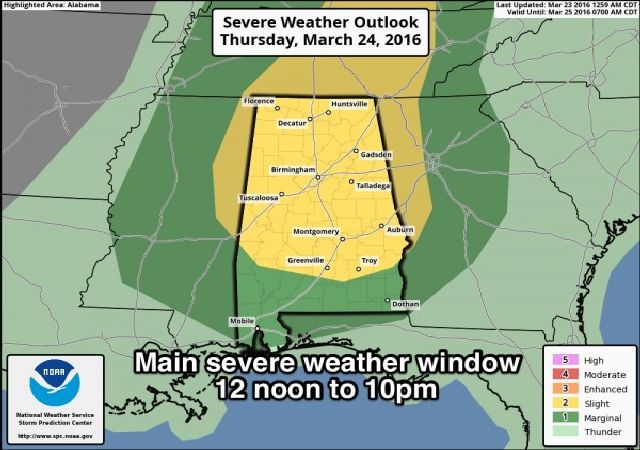
PLACEMENT: SPC has defined a “slight risk” of severe weather over the northern two-thirds of the state, roughly north of a line from Thomasville to Chapman to Eufaula. A “marginal risk” extends south to Mobile and Dothan.

TIMING: While a few strong/severe storms could enter Northwest Alabama by late morning, the core window for severe weather will come from 12:00 noon to 10:00 p.m. The severe storms will gradually move from west to east during this 10 hour period.
MODES: The core threat will come from strong, possibly damaging straight line winds, but a few tornadoes are certainly possible with projected STP (significant tornado parameter) values around 3 units. Highest tornado threat will come over the “slight risk” area. Stronger storms will also be capable of producing some hail.
RAIN AMOUNTS: Rain totals of 1/2 to 1 inch are likely, not enough for widespread flooding problems.
CALL TO ACTION: Be sure you are able to hear severe weather watches and warnings tomorrow; have a properly programmed NOAA Weather Radio, and a good smart phone app like WeatherRadio by WDT that is designed for warnings. If you read the blog, you are aware of this, but be sure and let your friends know. You can watch our live coverage on the ABC 33/40 app… see more preparedness notes here.
FRIDAY: Cooler, drier air returns; the sky should be mostly sunny with a high in the low to mid 60s. Friday morning will be chilly with a low around 40, and colder pockets could drop into the 30s with a little light frost possible in scattered spots.
EASTER WEEKEND: Saturday looks dry and warmer; a partly sunny sky with a high in the mid 70s. Unfortunately rain returns to the state Sunday. Best chance of rain for North/Central Alabama seems to be from about mid-morning on through the afternoon hours. A thunderstorm or two is possible, but for now severe weather is not expected.
NEXT WEEK: The GFS keeps rain going into Monday; in fact it shows a surface low near Memphis Monday with potential for strong storms here, but the ECMWF is totally dry, and we will lean toward that solution since it has performed much better in recent weeks and months (as usual). Next rain/storm event will come around Thursday (March 31)… that one will need to be monitored for severe weather potential. See the Weather Xtreme video for maps, graphics, and more details.
AT THE BEACH: Dry and pleasant weather today on the coast from Panama City Beach west to Gulf Shores, but showers and storms return tomorrow afternoon and tomorrow night. Friday will be dry, but the Easter weekend will be wet at times. See a very detailed Gulf Coast forecast here.
STORM SPOTTER TRAINING: Storm Spotter Xtreme is Saturday, April 9 at the BJCC from 9am to 2pm. This will feature both the basic and advanced SKYWARN classes, along with a session from Kevin Laws of the Birmingham NWS office. And, if you come, you get free admission to the Alabama International Auto Show, going on at the BJCC that same day. There is no cost and no need to register. Just show up with a curious mind. Kids 10 and older will also enjoy this if they love weather and want to learn more. Please help us make the severe weather warning process better!

WEATHER BRAINS: Don’t forget you can listen to our weekly 90 minute netcast anytime on the web, or on iTunes. This is the show all about weather featuring many familiar voices, including our meteorologists here at ABC 33/40.
CONNECT: You can find me on all of the major social networks…
Facebook
Twitter
Google Plus
Instagram
For more weather news and information from James Spann and his weather team, visit Alabama WX.


