James Spann: Severe storms possible Thursday for Alabama
James Spann Alabama NewsCenter Weather Forecast March 30 from Alabama NewsCenter on Vimeo.
ONE MORE DRY DAY: We will forecast a mix of sun and clouds across Alabama today with a high in the mid 70s, but very active weather is likely to the west, where severe storms are possible from the western Gulf Coast region up into the Corn Belt. There is an “enhanced” severe weather risk today from near Jackson, MS over to Lake Texoma. Higher tornado probabilities this afternoon and tonight are from near Jackson to Shreveport.
VERY ACTIVE/UNSETTLED WEATHER AHEAD: A complex severe weather threat is ahead for Alabama; storms will enter West Alabama after midnight tonight, and those could be strong, possibly severe. SPC has a “marginal” risk into the far western part of Alabama for this possibility, but the storms should be generally weakening during the pre-dawn hours. But, this is late March and we always have to watch any convection this time of the year, the core of the spring tornado season.
SEVERE WEATHER THREAT: The early morning storms will move out, and there is a decent chance we will be dry during the midday hours tomorrow, with potential for some breaks in the overcast. If we do see some sun, temperatures could approach 80 degrees tomorrow afternoon, making for a very unstable atmosphere with dewpoints well up in the 60s.
On the maps, a deep surface low will be over the Great Lakes with a slow moving front trailing the low. No doubt instability will be impressive here, but the dynamics during the day are somewhat marginal with the low level jet (5,000 feet) weakening to under 40 knots. But, that jet is expected to strengthen late in the day and into tomorrow night, providing dynamic support for severe storms. Forecast lapse rates and bulk shear values also support severe storms.
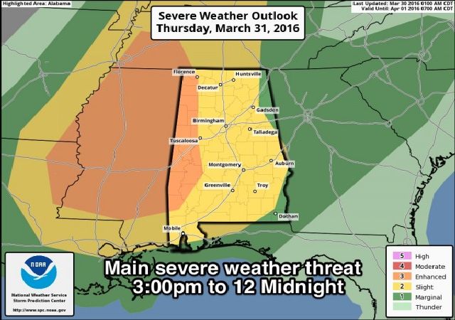
TIMING: We project the main severe weather window now from 3:00 p.m. until 12:00 midnight. Note that early morning storms tomorrow over West Alabama could be strong, possibly severe, and late tomorrow night the risk of severe storms could linger past midnight in parts of Central Alabama. But the focus for now will be on that nine hour stretch.
PLACEMENT: SPC has an “enhanced risk” of severe storms defined for tomorrow afternoon and tomorrow night for for far West Alabama, generally along and west of U.S. 43. The rest of the state is under the standard “slight risk”. Highest tornado potential will be over North and West Alabama late tomorrow and tomorrow night.

MODES: Stronger storms tomorrow and tomorrow night will be capable of producing hail, strong, possibly damaging winds, and a few tornadoes.
FLOODING: Rain amounts could exceed three inches in some spots by late tomorrow night, and some flooding is very possible where heavier rain develops. Generally speaking, rain amounts will average 1-2 inches.
CONFIDENCE: This is still a complex situation, and the overall severe weather threat will be determined by smaller, mesoscale features that are hard to identify in advance. Understand this forecast can, and probably will change over the next 24 hours, so keep checking the blog for updates.
CALL TO ACTION: Be sure you can hear severe weather watches and warnings, if needed, and know where you are going in the event you are placed in a tornado warning polygon. See this post about good apps to have on your phone on severe weather days (and anytime!), and other important safety information.
FRIDAY: The risk of severe storms will continue Friday, mainly over the southern half of the state. SPC has the standard “slight risk” defined for areas generally south of a line from Demopolis to Jemison to Wedowee.

The main severe weather threat Friday will come from straight line winds and hail, although a tornado can’t be ruled out.
Clouds will linger much of the day over North Alabama, but we could see some sunshine by mid to late afternoon. The high will be in the 70s for most places, as the cooler air won’t arrive until Friday night.
THE ALABAMA WEEKEND: Expect a good supply of sunshine Saturday and Sunday with highs in the 60s, but rather chilly nights. Coldest morning will come early Sunday, with lows in the 37-42 degree range. Colder valleys and protected areas could easily see low to mid 30s with frost; growers beware.
NEXT WEEK: The weather stays dry for the first half the week; the GFS is now showing a secondary push of cooler air moving into the state Tuesday, and that could push temperatures into the 30s across some of the colder spots early Wednesday morning. Much of the week will be rain-free…. see the Weather Xtreme video for maps, graphics, and more details.
AT THE BEACH: Clouds increase today, and showers and thunderstorms are likely on the Gulf Coast from Gulf Shores over to Panama City Beach tomorrow and Friday. The weekend will be mostly dry with a good supply of sunshine Saturday and Sunday. Highs will be mostly in the 70s… See a very detailed Gulf Coast forecast here.
STORM SPOTTER TRAINING: Storm Spotter Xtreme is coming up Saturday, April 9 at the BJCC from 9am to 2pm. This will feature both the basic and advanced SKYWARN classes, along with a session from Kevin Laws of the Birmingham NWS office. And, if you come, you get free admission to the Alabama International Auto Show, going on at the BJCC that same day. There is no cost and no need to register. Just show up with a curious mind. Kids 10 and older will also enjoy this if they love weather and want to learn more. Please help us make the severe weather warning process better!
WEATHER BRAINS: Don’t forget you can listen to our weekly 90 minute netcast anytime on the web, or on iTunes. This is the show all about weather featuring many familiar voices, including our meteorologists here at ABC 33/40.
CONNECT: You can find me on all of the major social networks…
Facebook
Twitter
Google Plus
Instagram
For more weather news and information from James Spann and his weather team, visit Alabama WX.


