Brian Peters: Heat going up, up in Alabama
Brian Peters: It’s going to get hotter in Alabama from Alabama NewsCenter on Vimeo.
TODAY’S WEATHER: There were a few clouds in the Central Alabama sky this morning, but as that huge ridge to our west continues to nose slowly into the Southeast U.S., the heat will continue to climb. I expect to see highs mainly in the lower 90s – the high in Birmingham yesterday was 92 – but some spots will certainly challenge the mid 90s. If you are looking for some real heat, try Death Valley, California, where the high yesterday was 126 degrees, but the humidity was around 5 percent.
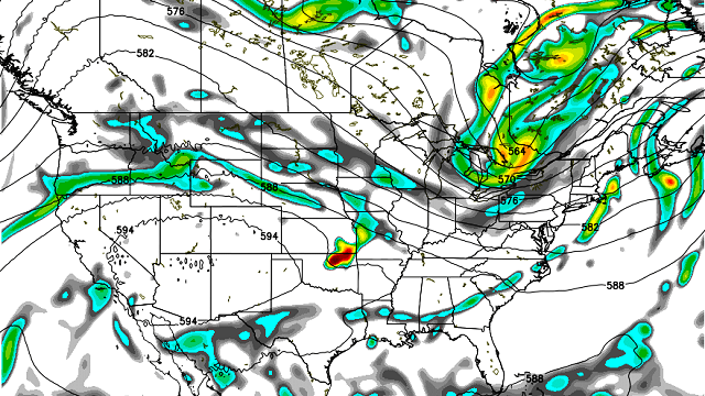
The Midwest is looking at a very active day today in a band running from southern Minnesota across the Chicago area and into western Ohio to about Cincinnati. All modes of severe weather will be possible, and there is a potential to see a long-lived derecho event. The severe weather in the vicinity of Chicago is likely to wreak havoc with flights later today and into tonight.

The severe weather risk shifts to the Mid-Atlantic states on Thursday. By Friday, still a slight risk in the Carolinas and another one centered on northern North Dakota.
Fortunately, the tropics remain quiet.
AT THE BEACH: Great week for beachgoers underway along the beaches of Alabama and Northwest Florida. You’ll find mostly sunny skies, only isolated afternoon and evening showers and storms, and warm temperatures typical of June this week. Highs will be near 90. Lows will be in the middle 70s. The sea water temperature at Perdido Pass at Orange Beach was 82 degrees. See the complete Gulf Coast seven-day planner here.
THE WEEK AHEAD: The ridge will remain the feature of interest in our weather pattern through the weekend and into Monday. A front drags into the Southeast U.S. Friday, so it looks like isolated showers will be possible on that day and into the weekend. Because the upper ridge is going to build stronger on Saturday, we will probably see some pretty hot days with highs in the upper 90s. And with humidity values up, heat indices could increase to 105 degrees or higher, so a heat advisory may be required over the weekend. This kind of heat can certainly sneak up on you, so be sure to use good sense by limiting outdoor work, exercise or play and be sure to stay hydrated while you are active outside.

A strong trough/closed low moves along the U.S.-Canadian border on Sunday and Monday, which will help to beat back the ridge and force it to retrograde. This action should lower the heat for us by Monday. Combine this upper air action with the approach of a cold front Monday and Tuesday which will improve rain chances and produce considerably more clouds, and it sure looks like we will see a break in the heat. Highs Monday and Tuesday will probably drop back to around 90.

Come next Wednesday, the GFS is projecting a broad trough across the eastern U.S., which places the Southeast U.S. under a northwesterly flow pattern. The GFS is hinting at the potential for a minor short wave in the Kansas/Nebraska area. While there is not much skill in the specific forecast of a mesoscale convective system (MCS) this far out, it is a reminder that we’ll need to stay on our toes and be vigilant about one of these long-lived thunderstorm events that can affect us.
Enjoy your day and stay cool.
James Spann is on vacation. For more weather news and information from Brian Peters and the rest of the James Spann team, visit AlabamaWX.


