James Spann: Dry through at least Friday in Alabama
James Spann Alabama NewsCenter Weather Forecast September 6 from Alabama NewsCenter on Vimeo.
AT LEAST MORNINGS ARE COOLER: Lower dew points slipped into Alabama yesterday, and accordingly it feels pretty good early this morning with most places down in the 60s. Birmingham is reporting 68 degrees at 6:00… first time it has dropped below 70 since July 1. Fort Payne is down to 61 for a nice touch of fall.
The sky is clear, and we expect a good supply of sunshine today with a high in the low 90s. Humidity values will be relatively low, however, so it won’t feel as oppressive as August.
TOMORROW THROUGH FRIDAY: No real change. Mostly sunny days with hot afternoons, but clear pleasant nights. Highs in the 91-94 degree range; lows in the upper 60s for most communities. Sinking motion associated with the upper high over the region, and dry air will prevent showers from forming.
THE WEEKEND: Don’t expect much change. Saturday looks partly sunny and dry with a high at or just over 90 degrees. We will mention a slight risk of a shower Sunday afternoon with a weakening front approaching from the north, but the air stays dry, and the chance of any one spot getting wet will be small. Sunday’s high should drop a bit into the upper 80s.
And, into next week still no sign of any widespread, beneficial rain with the storm track holding well to the north, and upper ridging holding across the Deep South. See the Weather Xtreme video for maps, graphics, and more details.
FOOTBALL WEATHER: High school games played under Friday night lights across Alabama will be rain-free with a clear sky; temperatures will fall from the mid 80s at kickoff into the 70s by the final whistle.
Alabama hosts Western Kentucky Saturday at Bryant-Denny Stadium for the 2016 home opener (2:30p CT kickofF)… the sky will be mostly sunny with 90 degrees at kickoff… dropping back into the mid to upper 80s by the end of the game.
Auburn will host Arkansas State at Jordan Hare Stadium Saturday evening (6:30p CT kickoff)… the sky will be clear with temperatures falling from 87 at kickoff into the upper 70s by the fourth quarter.
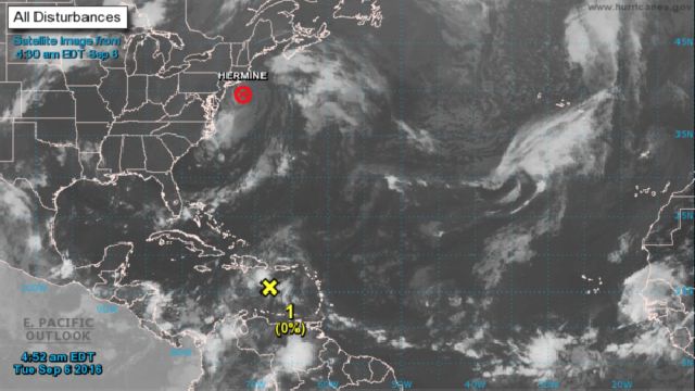
TROPICS: “Post-tropical” storm Hermine will loop off the upper Atlantic coast in coming days, and it still producing dangerous rip currents and rough surf there. It finally kicks out to sea this weekend.
A weak wave in the Caribbean will likely move into Central America or the Yucatan without development.
And, another wave in the eastern Atlantic has some chance of development in 3-5 days… just something to watch for now.

AT THE BEACH: Expect mostly sunny days and fair nights on the Central Gulf Coast (Gulf Shores to Panama City Beach) through the weekend with only isolated storms. Highs in the upper 80s on the immediate coast, with low 90s inland. See a very detailed Gulf Coast forecast here.
WEATHER BRAINS: Don’t forget you can listen to our weekly 90 minute netcast anytime on the web, or on iTunes. This is the show all about weather featuring many familiar voices, including our meteorologists here at ABC 33/40.
CONNECT: You can find me on all of the major social networks…
For more weather news and information, visit AlabamaWX.


