James Spann: Severe storms possible in Alabama this weekend
James Spann: Alabama faces three rounds of possible severe weather this weekend from Alabama NewsCenter on Vimeo.
ACTIVE PATTERN: A complex severe weather situation is setting up for Alabama over the weekend, but today will be fairly quiet. Morning clouds will give way to some afternoon sunshine, just a small risk of a shower, and afternoon temperatures reach the mid 70s, right around record levels for mid to late January in Alabama.
There will be three windows for severe storms across Alabama over the next two days. Let’s take them one at a time.
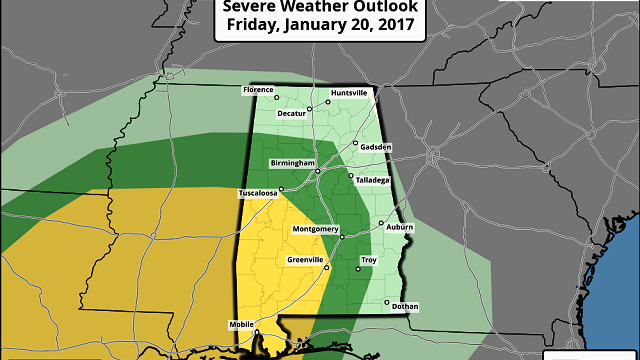
ROUND ONE: The first chance of severe storms will come from roughly 3 a.m. until 9 a.m. tomorrow as a deep upper trough gets closer with strong wind fields, deep shear and unstable air. The Storm Prediction Center has parts of west and southwest Alabama in the standard “slight” risk of severe storms, with a “marginal” risk northeast to Birmingham. Understand this is for the overnight storms we expect late tonight, after midnight.

ROUND TWO: There should be a lull in storm activity across the state during the midday tomorrow, allowing temperatures to rise into the low 70s, with increasing instability values. A few scattered storms could form tomorrow afternoon and evening, generally in the 3 p.m. to 9 p.m. time frame. This is a much more conditional threat; some of the good high-resolution models show no development at all. But, considering the thermodynamic fields, we sure can’t rule out a few scattered severe storms in this window. In their “Day Two” outlook, SPC has an “enhanced risk” up for parts of west Alabama, and the standard “slight” risk identified for the rest of the state.

ROUND THREE: The final window for severe storms will come from about 3 a.m. through noon Sunday, when the main upper low moves in from the west. By Sunday afternoon, the main severe weather risk shifts down into southwest Alabama, where SPC has the standard “slight” risk up.

The bottom line is that there could be multiple rounds of strong to severe storms over the weekend, but there will also be some good breaks in the rain.
THREATS: During each window over the weekend, storms could produce large hail, damaging winds and a few tornadoes.
RAIN: Additional rain amounts of 1-3 inches are likely; major flooding issues are not expected.
CALL TO ACTION: Be sure you have a way of hearing severe weather watches and warnings. At home, you need a properly programmed NOAA Weather Radio with a battery backup. On your phone, for warnings we recommend WeatherRadio by WDT. You can watch our live severe weather coverage on the free ABC 33/40 app. Here are the links:
Review your action plan in case a tornado warning polygon includes your home. Get in a small room, on the lowest floor, away from windows and near the center of the house. You do NOT have to be underground. Never be in a car or mobile home.
NEXT WEEK: Monday will be cloudy, windy and much cooler with some lingering light rain, mainly during the morning. The high will be in the 50- to 55-degree range. Even colder air arrives later in the week, with highs dropping into the 40s.
As always, watch me for the full weather story on ABC 33/40 News this evening at 4, 5, 6 and 10.
WEATHER BRAINS: You can listen to our weekly 90-minute netcast anytime on the web, or on iTunes. This is the show all about weather featuring many familiar voices, including meteorologists at ABC 33/40.
CONNECT: You can find me on all of the major social networks:
Facebook
Twitter
Google Plus
Instagram
Snapchat: spannwx
For more weather news and information, visit AlabamaWX.


