James Spann: A few strong storms tonight for Alabama
James Spann: Warm winter day for Alabama, with possible storms tonight from Alabama NewsCenter on Vimeo.
FOGGY START: A dense fog advisory is in effect for much of north, central and west Alabama early this morning; otherwise the sky is cloudy, nothing is on radar and temperatures are between 55 and 60 degrees.
A decent part of the day will be dry, and we might even see a few peeks of sun this afternoon. It will be a warm February day with a high between 70 and 74 degrees for most communities.
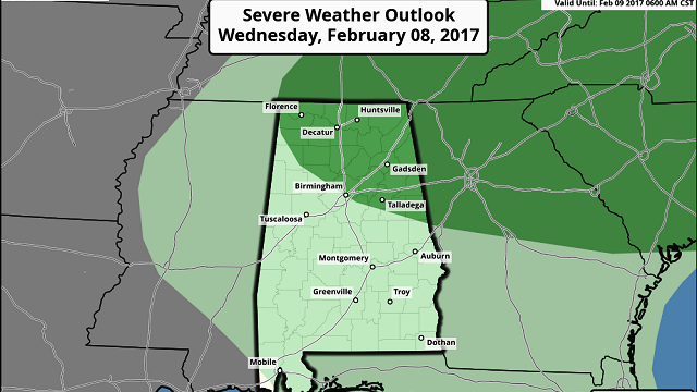
STRONG STORMS POSSIBLE TONIGHT: A surface cold front will pass through tonight, and the Storm Prediction Center has a “marginal” severe weather risk defined for Northeast Alabama.

There will be sufficient shear and instability for sustained updrafts; the main threat will come from hail and gusty thunderstorm winds. With a rather unidirectional wind profile, the chance of a tornado looks very low for now. The main window for stronger storms will come from 6 p.m. until midnight.
COLDER TOMORROW: The sky becomes mostly sunny tomorrow, but the day will be very cool and breezy with a high close to 50 degrees; most communities north of Birmingham will hold in the 40s all day. Then we go below freezing early Friday morning, with a low between 25 and 29 degrees. Friday will be cool and dry, with ample sunshine and a high between 55 and 59 degrees.
THE ALABAMA WEEKEND: We warm up nicely; Saturday will be dry with a pretty decent amount of sun and a high in the 67- to 70-degree range. Then, on Sunday, the sky will be mostly cloudy with some risk of scattered showers, but the rain won’t be especially heavy or widespread. The weather stays very mild with a high up in the low 70s Sunday afternoon.
NEXT WEEK: We will hold on to the risk of a few scattered showers Monday, but the next widespread rain comes Wednesday and Wednesday night as a deep surface low moves right over Alabama. For now it looks like any severe weather threat will be confined to the far southern counties of the state, and rain amounts in the 1-inch range look likely. Cooler air returns following the rain Thursday and Friday.
TUESDAY RAIN AMOUNTS: Totals yesterday included 1.53 inches at Helena, 1.35 at McAdory, 1.12 at Jemison, 1.11 at Coker, 1.08 at Bessemer, 1.01 at Cottondale, .98 at Mountain Brook, .89 at Trussville, .78 at Heflin and .63 at Hayden.
WEATHER BRAINS: You can listen to our weekly 90-minute netcast anytime on the web, or on iTunes. This is the show all about weather featuring many familiar voices, including meteorologists at ABC 33/40.
CONNECT: You can find me on all of the major social networks:
Facebook
Twitter
Google Plus
Instagram
Pinterest
Snapchat: spannwx
For more weather news and information, visit AlabamaWX.


