James Spann: Soaking rain hits tonight, with storms for South Alabama
James Spann: Cold rain for Alabama tonight, possible strong storms on Gulf Coast from Alabama NewsCenter on Vimeo.
COLD MORNING: Some communities like Gadsden, Cullman, Haleyville and Fort Payne are starting the day below the freezing mark, with mid to upper 30s elsewhere. But we warm up nicely today, with a high in the 60s this afternoon. Clouds will steadily increase ahead of a storm system to the west, where rain covers much of Texas this morning. In fact, a tornado watch is in effect for parts of Southeast Texas, including Houston.
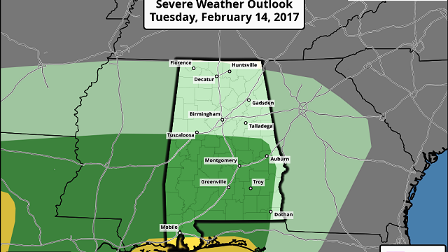
TONIGHT: Rain should enter West Alabama tonight sometime between 8 and 10 p.m. and become widespread after midnight. A surface low will track right across Central Alabama overnight, meaning we could see strong storms over the southern half of Alabama. The Storm Prediction Center has a “marginal risk” of severe storms defined as far north as Tuscaloosa and Alexander City, but the core threat tonight will be along the immediate Gulf Coast, where SPC has the standard “slight risk” outlined.

A few storms over South Alabama late tonight and early tomorrow could produce strong, gusty winds and hail, and the tornado threat will be mostly along and south of U.S. 84. The northern half of Alabama will simply see a cold rain, with amounts between one-half and 1 inch for most communities.
TOMORROW: Rain will end from west to east pretty early in the day, and we might even see some sun breaking through by afternoon. It will be a cool day with a high only in the mid 50s.
THURSDAY/FRIDAY: We expect a low in the 28- to 32-degree range early Thursday morning; the day Thursday will be sunny with a high in the mid to upper 50s. Friday looks nice, with ample sunshine and a high in the 60s.
THE ALABAMA WEEKEND: A wave aloft will bring clouds to the state Saturday, and we will mention the chance of a few scattered showers, but nothing especially heavy or widespread. The latest Global Forecast System output suggests the best chance of a shower will come Saturday morning; the day should be mostly cloudy with a high in the 60s. Then, Sunday looks delightful, with a partly to mostly sunny sky and a high not too far from 70 degrees.
NEXT WEEK: Seems like the next chance of rain will come Tuesday night into Wednesday; a few thunderstorms could be involved, but too early to determine if severe weather will be an issue. Then, dry and mild weather is expected for the latter half of the week. Still no sign of any extremely cold Arctic air shows for the Deep South through the rest of February.

WEATHER BRAINS: You can listen to our weekly 90-minute netcast anytime on the web, or on iTunes. This is the show all about weather featuring many familiar voices, including meteorologists at ABC 33/40.
CONNECT: You can find me on all of the major social networks:
Facebook
Twitter
Google Plus
Instagram
Pinterest
Snapchat: spannwx
For more weather news and information, visit AlabamaWX.