James Spann: Warmer Tuesday, stormy Wednesday in Alabama
RADAR CHECK: The most widespread rain across Alabama is now south and east of Montgomery, but more showers are moving into West Alabama from Mississippi.

There is also a huge thermal contrast across the state; North Alabama communities are in the cool 50s north of a warm front near U.S. 84, but south of that front, temperatures are up in the mid 70s at Mobile and Dothan. The warm front will be lifting northward tonight, and we will maintain the chance of a few passing rain showers.
TUESDAY: It will be a warmer day with temperatures in the 70s statewide. There will be sufficient moisture and instability for scattered showers and thunderstorms, but, with no real forcing mechanism nearby, the rain won’t be especially widespread, and there is no significant risk of severe weather across Alabama. Pretty decent chance the sun will break out at times.
We note a significant severe weather event is possible tomorrow in the broad zone from Dallas to Cleveland; there is an “enhanced risk” of severe storms tomorrow and tomorrow night over parts of Arkansas, Missouri and Illinois.
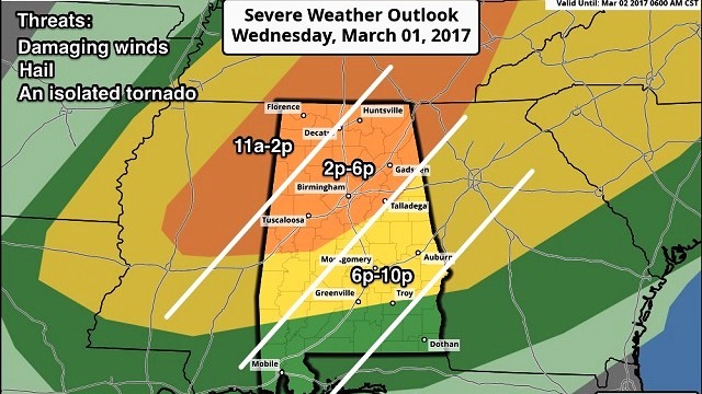
SEVERE STORMS IN ALABAMA WEDNESDAY: A cold front will approach with good support from an upper trough, and strong to severe thunderstorms are possible in Alabama. The Storm Prediction Center maintains an “enhanced risk” of severe storms for much of North/Central Alabama. A “slight risk” is as far south as Grove Hill, Greenville and Eufaula, and a “marginal risk” extends down into far South Alabama.

TIMING: Storms should move into Northwest Alabama by late morning, then reach Birmingham, Tuscaloosa, Anniston and Gadsden between 2 and 6 p.m. The storms move down toward Montgomery and Auburn after 6 p.m.
THREATS: Forecast wind profiles suggest the primary threat will come from damaging winds along the squall line ahead of the front. Hail is also possible with the stronger storms. And we can’t rule out an isolated tornado or two, especially in storms that form ahead of the line Wednesday afternoon.
RAIN AMOUNTS: Totals of one-half to 1 inch are expected Wednesday, so major flooding issues are unlikely.
Understand the forecast timing could very well change as new data comes in tonight. Be sure and check here and on AlabamaWX for updates as we get closer to the event Wednesday.
THURSDAY/FRIDAY: Cool, dry air rolls in; we expect a good supply of sunshine both days. The high Thursday will be in the mid 60s, then we drop into the 28- to 32-degree range early Friday morning for another late-season freeze. The high Friday afternoon will be in the 57- to 60-degree range.
THE ALABAMA WEEKEND: Looks like another freeze early Saturday morning (the Global Forecast System is printing a low of 31 for Birmingham). We warm into the low 60s Saturday afternoon with a sunny sky. Sunday will be partly to mostly sunny with a high in the mid to upper 60s.
NEXT WEEK: Another cold front will push through on Tuesday with a chance of showers and thunderstorms; for now the severe weather threat looks fairly low. Then, more cool air arrives Wednesday with potential for another late-season freeze at some point in the latter half of the week.
WEATHER BRAINS: You can listen to our weekly 90-minute netcast anytime on the web, or on iTunes. This is the show all about weather featuring many familiar voices, including meteorologists at ABC 33/40. We will produce this week’s show tonight at 8:30. You can watch it live here.
CONNECT: You can find me on all of the major social networks:
Facebook
Twitter
Google Plus
Instagram
Pinterest
Snapchat: spannwx
For more weather news and information, visit AlabamaWX.


